

CA63 - Cliffs coming up broken
Hi everyone
I'm really new to Campaign Cartographer, the whole process of getting to grips on it has been... interesting.
I'm trying to draw a map for a hex crawl for the Dark Souls RPG. Because the crawl is going to take place across the tops of a couple levelled limestone cliffs, I was thinking I'd use the city cliffs style from the 2020 annual (C64), as it'd make my life easier.
I'm following the annual tutorial, but I'm running into issues on the very first step. Namely, the cliffs appear as fragments:
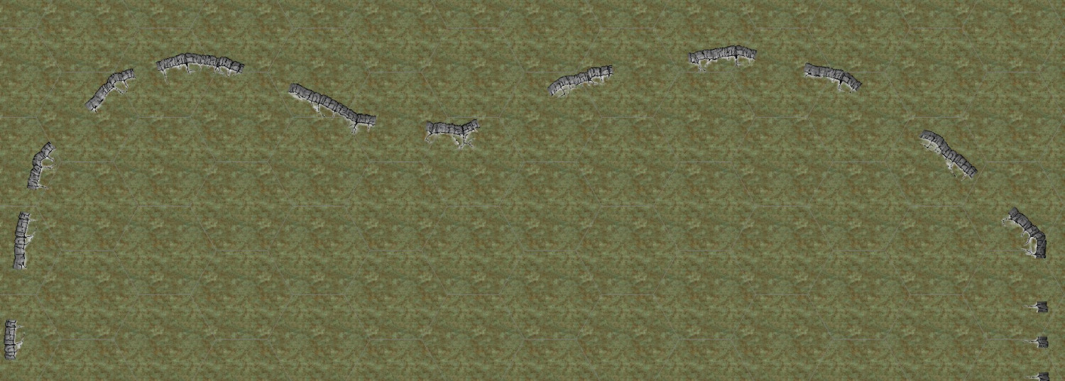
What am I doing wrong? I've tried simpler shapes and it doesn't seem to make a difference. I've checked I'm on the right sheet.
Apologies if this has been asked to death, or if I'm doing something dumb!
Thanks and regards
Best Answer
-
 Loopysue
ProFantasy 🖼️ 41 images Cartographer
Loopysue
ProFantasy 🖼️ 41 images Cartographer
The cliffs only work in imperial maps. Since most mappers seem to use imperial this wasn't realised until long after the release. Unfortunately I have tried my hardest to get connecting symbols to work in metric maps, but have only succeeded with symbols that have no actual corners in them, like the hedges and walls in Darklands City (2021 annual). The cliff symbols are mostly corners. That is where the symbol is designed to take the line around a corner of a specified angle.
You can use them if you increase the default symbol scale to 1 from 0.3048 in the drawing properties dialog (top bar button
 )
) 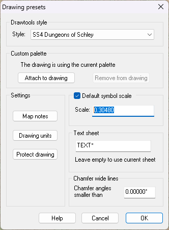
Remember to return this to 0.3048 once the cliffs are done or all your other symbols will be too small.
The disadvantage of doing it that way is that the cliffs may look a bit too small and more like a stone ridge than a cliff.
Alternatively, try using an imperial template instead.

Answers
The cliffs only work in imperial maps. Since most mappers seem to use imperial this wasn't realised until long after the release. Unfortunately I have tried my hardest to get connecting symbols to work in metric maps, but have only succeeded with symbols that have no actual corners in them, like the hedges and walls in Darklands City (2021 annual). The cliff symbols are mostly corners. That is where the symbol is designed to take the line around a corner of a specified angle.
You can use them if you increase the default symbol scale to 1 from 0.3048 in the drawing properties dialog (top bar button )
)
Remember to return this to 0.3048 once the cliffs are done or all your other symbols will be too small.
The disadvantage of doing it that way is that the cliffs may look a bit too small and more like a stone ridge than a cliff.
Alternatively, try using an imperial template instead.
I also found this. It is disappointing that imperial seems to reign supreme in CC3+, even in the video tutorials of Remy and Ralf, where they nearly always use imperial, even though all Europe, except for UK uses metric, as does the rest of the world except USA. But as UK and USA are the main CC3+ customers, I understand that. I just wish developers would take more care to make sure everything works in metric as well. I have got around it by using scale of 1.5, rather than 1, then resetting. Still annoying though, since I always use metric - I can no longer really visualize imperial since Australia metricized decades ago. And even the UK is half metric (which is super weird and must annoy UKers a lot, I would suppose)
That's great, thank you!
I'm in the UK but lived in South America before that, so I'm completely in the metric... well, I've found most people I know here use the metric system, so I wouldn't call it the metric half. More of a metric majority maybe.
Sue,
Do I recall correctly in that there was a past issue with some of the drawing tools for your cliff style? I'm trying to follow the tutorial and the selections available are not the ones shown in the text.
It's been a while since I created them seycyrus, so my aging memory isn't recalling anything more than that they don't work in metric maps because of the corners.
Which tutorial are you refering to? Is it the Mapping Guide or the live mapping session Ralf did to cover how to use them?
@Loopysue,
I haven't used the program in a few months. In fact, it was the thread about cliffs that caused me to shake off the cobwebs. Great stuff!
My problem is in following the mapping guide. I'm pretty sure I know how things SHOULD work. When I get to the "Drawing the Clifftop" part, opening up the drawing tools does not show what I assume (from looking at the guide) the proper fills. I assume that the fill should be the same as the map uses opening up but one shade lighter.
It also does not seem to be be placing things on the proper sheets (no shadows cast). I assume that there is a clifftop sheet, and perhaps a cliff base sheet? I do not see additional sheets associated with cliffs besides CLIFFTOP and Symbols Cliffs
Any suggestions?
EDIT: Yes, I just compared the sheets between the fcw file of mapping guide and when I follow the guide myself. The sheets are definitely different. I have the symbols (connecting cliffs etc.) but things are otherwise messed up. Should I reinstall that annual?
I'm not sure what is going on there, but maybe if you haven't seen it before the live mapping session that Ralf did might help? He would have started with that same template - assuming you are using the imperial template.
https://www.youtube.com/watch?v=yWVbqY8Wxag
That couldn't have been 2 years ago! They just started doing the live mapping sessions just the other month ...
Thanks, I'll check it out.