

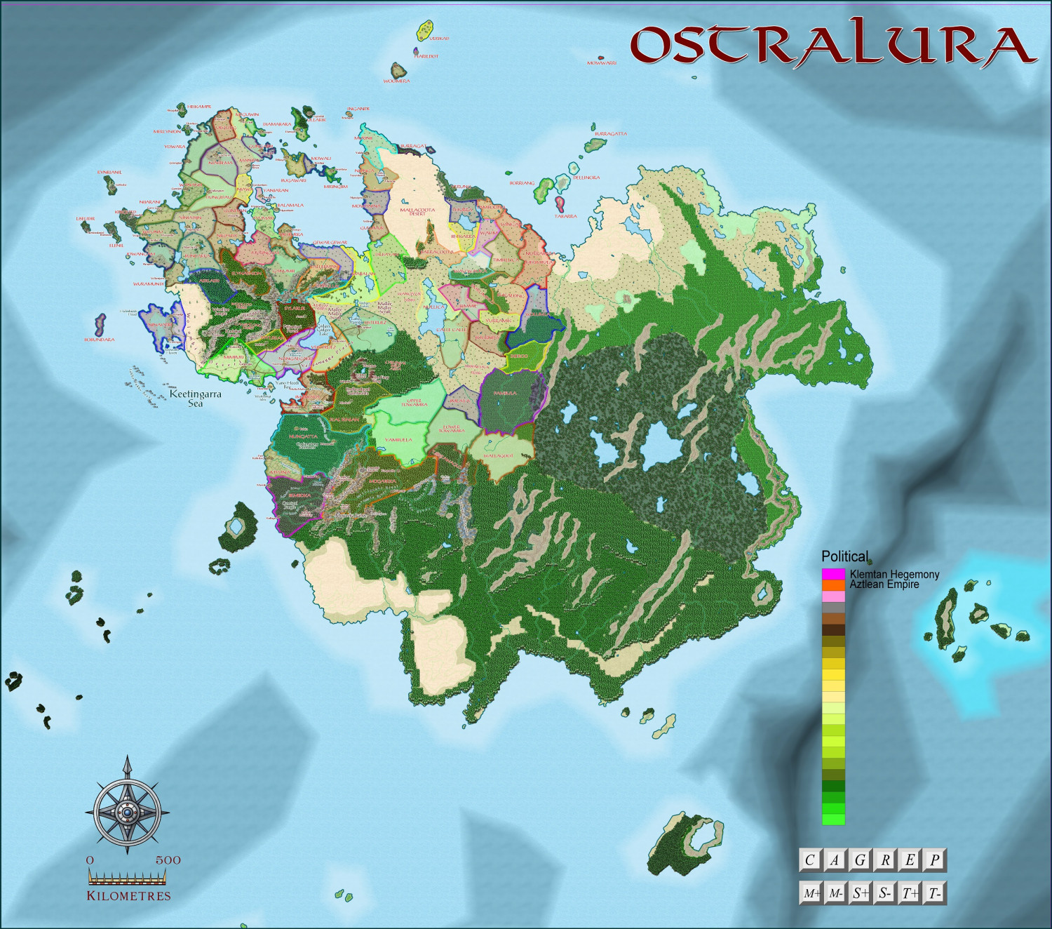
Ostralura - north-eastern region
 Quenten
🖼️ 125 images Mapmaker
Quenten
🖼️ 125 images Mapmaker
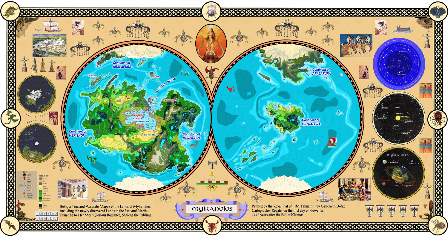
Placement of the continent of Ostralura on the planet of Myirandios
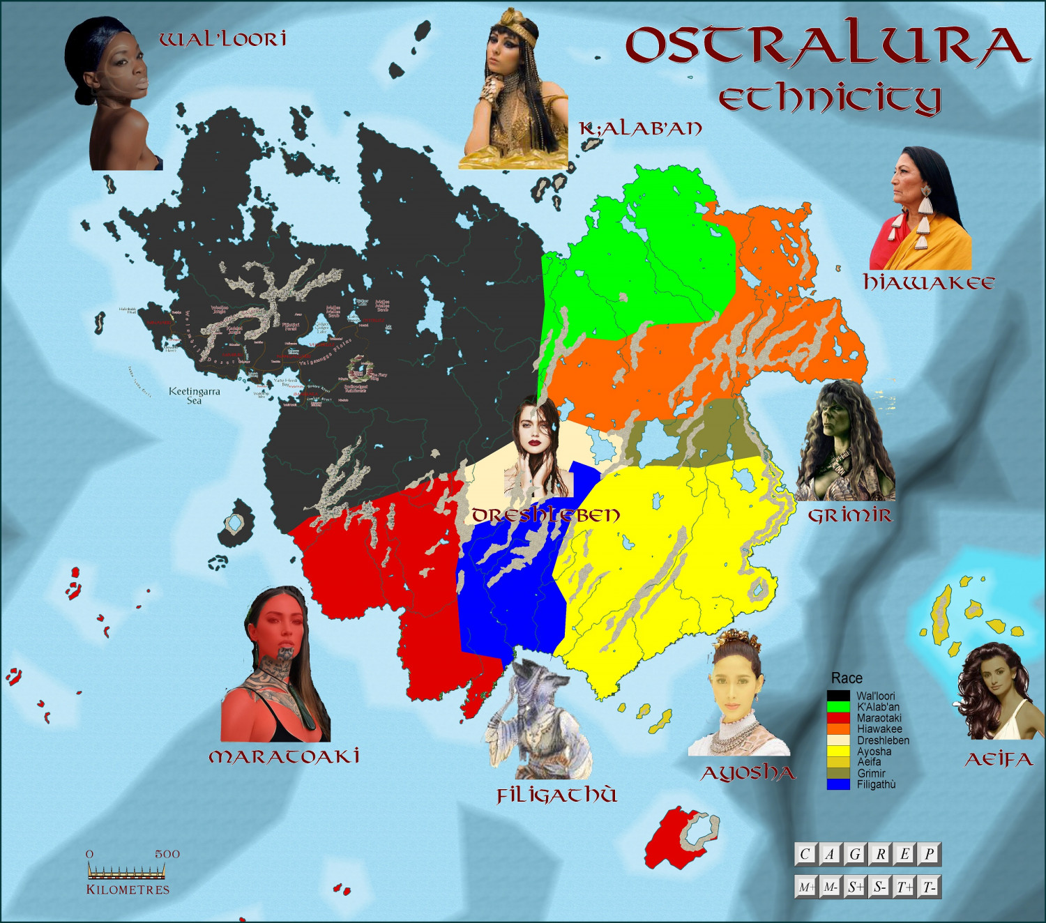
Wal'loori = Australian Aboriginal
Maratoaki = Maori
Ayosha - Thai
Dreschleben = Germanic
K'alab'an = Arab
Hiawakee = Cherokee
Aeifa = Elven
Grimir = Orc
Filigathu = Were
' sounded as a breathy sound break between syllables.


Comments
North-eastern Ostralura - dominated by Wal'loori, the most technically advanced on the continent.
The area I am concentrating on, the Mimburi-Imarbara region
And the same region done in Ellis's watercolour style
Close-ups of the various countries I will be detailing
Imarbara - Wal'loori Queendom
Bobundara - Aeifan Queendom
Mylirian - Aeifan Queendom
Nangalgarri - Wal'loori Republic
Ninajarri - Wal'loori Queendom
Osterliez - impoverished Dreschleben Duchy
Sylarlir - Aeifa Queendom
Veisterlitz, another impoverished Dreschleben Autarchy
And the Woolloo and Cambalong Tribal areas - Wal'loori clans. Also showing the two Davarin (Dwarven) fastnesses of Karaztor and Nalak Dum
Finally, the Republic of Mimburi - a Wal'loori newly made republic (formerly a declining empire), in decline, but still powerful regionally. This is the main subregion.I am basing its history and development on the real life Kingdom of Kongo, as an experiment in using real earth history and culture as templates for my world building. So, apart from name and geography changes, I will be making 3 significant changes in the 'real' history, and as well, keeping to the cultural basis I have set for the whole planet. ie white males (Dreschleben, in this area) occupy the same political, social and cultural niche as black women do in 1980's USA and black females occupy that of white men in 1950's USA.
Magic is based on direct manipulation of electromagnetic spectrum (etherics) which is far stronger (on average) in women then men - sort of like muscular strength sexual differences in real earth cultures, only more pronounced. And, as an aside, using etherics consumes lots of calories, so the most proficient ethericists have a small army of professional chefs to keep them well fed. So a way of social advancement for males is by getting employed as an ethericist chef!!
Here is the start of the history
The Republic of Mimburi is located in northwest Ostralura. At its greatest extent it reached from the Wolumbil Desert in the west to the Gidgee Gidgee Lake and Yalgamugga Plains in the east, and from the Jinnerwalti Ranges in the north to the Bundoo River in northern Imarbara in the south. The Queendom consisted of several core provinces ruled by the Barami Mimburanti, meaning "lord or ruler of the Mimburi Queendom", but its sphere of influence extended to neighbouring Queendoms, such as Ninajarri, Mylerian and Imarbara.
From c. 560 AU – 780 AU it was an independent state. From 780 – 1023 AU it functioned intermittently as a vassal state of the Queendom of Djamabara. In 1023 AU, following the Djamabaran suppression of a Mimburi revolt, Djamabara abolished the titular monarchy. The title of Queen of Mimburi was restored from 1054 AU until 1104 AU, as an honorific without real power. The remaining territories of the Queendom were assimilated into the colony of Nangalgarri, Imperial Imarbara and modern Autarchy of Veisterliez respectively. The modern-day Bundu ja Mimburi sect favors reviving the Queendom through secession from Nangalgarri, the Republic of Mimburi, and Veisterliez.
History
Oral traditions about the early history of the country were set in writing for the first time in the late 6th century AU, and especially detailed versions were recorded in the mid-7th century, included those written by the Ninajarran Shalenè missionary Gubbi Cabarri. Traditions about the foundation changed over time, depending on historical circumstances.
Foundation of the Queendom
Before the founding of Mimburi, the region it would eventually control was under the control of several minor Queendoms, according to a tradition recorded in the mid-580s. It named several former Queendoms, which were included in Mimburi: Nundi, Mangulara and Matarri, along Lake Gidgee Gidgee on the east; and Wanduli south of them; then Nembara in the center, and Soyolo and Bambil on the seacoast west of the Yarloo River.
Seems to be some red X's in the second and third image from the bottom. Did you move some image files?
yes, fixed the Mimburi one, but I can't edit the first one.
First let me start by saying that is some amazing work and i can tell you put a ton of time into all those views. Outside being astonished the one comment I would make is the first view that shows the entire world and a few more things. I like some of the graphics and vews along the edges of the world map. However, There are some images that are repeated multiple times and they almost seem to be space fillers. A thought I had is if you removed most of those it would make the other images pop more and the thing feeling less busy.