

Cowpens Battlefield
 mike robel
🖼️ 15 images Surveyor
mike robel
🖼️ 15 images Surveyor
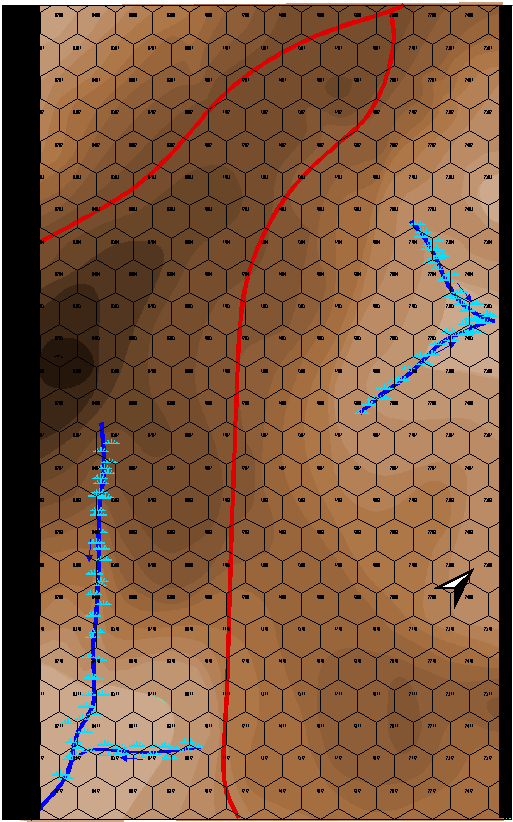
This is my map of Cowpens battlefield. The battle was a near decisive action in the American Revolution, partially portrayed in the movie "Patriot". The victory here caused Cornwallis to retreat to Yorktown. It is interesting terrain, but not a lot of relief. Part of the brilliance of the American Commander was he defended from ground that resulted in the British shooting high because of they way they 'aimed' when they were shooting down hill.
I am interested in only a few battles during the 1700-1800s. Cowpens, Saratoga, Yorktown, Gettysburg (1st Day), and the Little Bighorn. I jump from ancients to Modern with those few stops.
Each Hex is 200 feet. (odd for me, usually I think in meters for this sort of thing.) The map will be about 12 inches by 18 inches when completed.
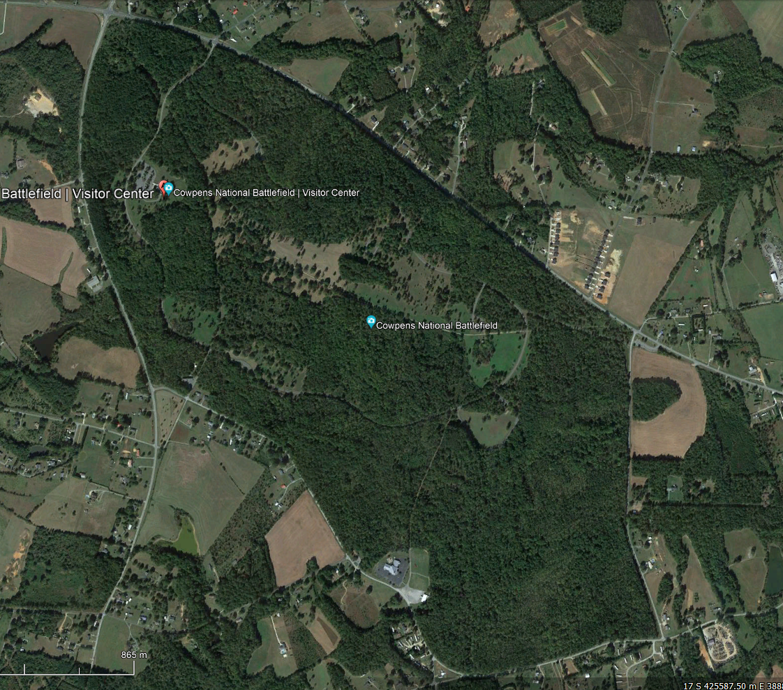
This is the battlefield today. There was not nearly as much forest.
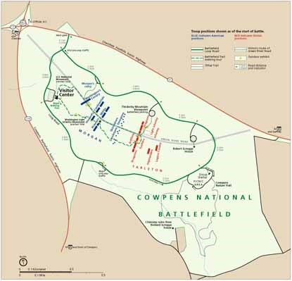
This is the battlefield layout. The US is on the left in Blue, the British are on the right in red, attacking generally from the South to the North. (Today in NATO and the "West" Blue is "Friendly" and Red is "Enemy". In a British World War II history I read, I was confused because the British were in Red and the Germans were Blue.).
The battle was fought in December. There apparently was some snow on the ground, but only a scattering of trees, which I have not put in yet. The question is, how to portray a 'dusting' of snow?
EDIT: I forget to mention, the terrain colors come from the 48 Shades of Brown Palette Andre made for me, as well as 48 Shades of Green, 32 shades of Green and Blue, and one that has 32 shades with 16 green and 16 brown that sort of blend into each other.


Comments
Great work, Mike :)
Though I am surprised about the aiming!
A dusting of snow is a really tricky thing - especially with this kind of map where its more about accuracy and altitude than artistic impression. Do you really need to partially obliterate the important information?
But if it's important maybe find a patchy snow fill and use it on a sheet with quite a strong transparency effect on it? Difficult to know what to suggest.
Apparently, they were told to level their guns with the horizon. I wrote from memory, so I probably should go back an reread it so it is correctly reported.
Oh dear! Well no wonder they couldn't shoot straight.
They didn't really aim in those days. They just sort of pointed the guns at the enemy. The American's though had a lot of riflemen (the British not so much) who aimed and fired quite well. But apparently the Americans also aimed even with muskets. Both sides also apparently used a load with one 'large" ball and three 'smaller' balls so they would spread out like a shot gun and hit someone.
The real mystery for me is how to do ?!SNOW!?
I edited my first comment when I realised I'd missed that bit right at the end.
I'm not sure how you are going to do it, so it's just a thought.
I looked at your Winter Trail thread. Maybe a white 'overlay' would work somehow. apparently there was rain, snow, and of course mud. It would not make any real difference to play, but would add atmosphere.
More important is playing with trees.
Well, here is a picture at the LBH in March of last year following a two day blizzard. It may not be worth the effort for my purposes. Some places had more, some had less. It wasn't particularly cold, even for a Florida boy. The previous two days though we didn't leave the hotel.
Not even sure how it would look from overhead.
I think it might be easier to just say that there is a dusting of snow and keep reminding players.
If I was a talented artist, like my oldest daughter, I might try for a look like the photo with a mixture of snow and mud. But since I'm not, I'm just gong to leave it as is. The battlefield was not as forested as it is today and there was no underbrush having been set alight to reduce vermin and encourage pasture for cattle and any wood available within reach used for firewood.
The path is the walkway for the battlefield tour and is not the road that ran through the battlefield.
It was very open, so I will be putting in some trees and that will be that. This was a brilliant double envelopment of the British by the Americans, sometimes called the American Cannae.
I'm also talking with an archeologist who wrote two books on the battle and I've been there 3 or 4 times.
Here is a picture where the Continental Cavalry under Colonel Washington (a cousin of the General) engaged in a melee with Colonel Tarleton's Cavalry Legion probably around HEX 0719 in the map, near the small stream on the bottom left of the map.
I suspect the red British markers in the WW2 text you mentioned Mike, might be because the traditional colour to show possessions of the British Empire (as it still was during WW2) was red. Plus it's been very commonly used in other military history and wargaming texts I've read as well down the years. There may be also an element that during the Napoleonic wars (indeed also in the almost-century before and after), many of the defining British troops wore red uniforms, the French blue, hence somewhere in all this came about the dominating idea of British = red. Probably!
Indeed. During the US Civil War, newspapers included those blue/red pencils in the north at least so readers could color in maps as battles progressed. Blue was for the United States Army and Red was for the Confederate States Army.
Interesting. I didn't know about the coloured pencils, though I have a longstanding interest in the events during said Civil War. Presumably the colour choices originated with the predominant shades used in the unit flags of the two sides, which, with variants, favoured blue for the Union forces and red the Confederates.
I found it out by going back for the origin of the Red and Blue election maps. For a while, each network used different colors but later converged.
I added a few trees - the battlefield was pretty well cleared and branches were chopped off as high as men on horseback could get (and any fences in the area dismantled) to provide fire wood.
This shows the units at the start of the battle (more or less). I am still researching where the units on the side belong.
The R or M stands for Regular or Militia.
The number is the combat strength of the unit.
The # sign represents the movement factor for the unit, probably the game turns are 2 minutes long and that will allow units to march at the Quick Step at 3 Hexes/Turn or speed up to 4 hexes per turn for charging/running. I will also add a range factor since the US had a mess of rifleman that could shoot 400 - 800 feet with a fair chance of hitting.
Looking good.