

From Quillan to Montsegur
 Prochaska
🖼️ 21 images Traveler
Prochaska
🖼️ 21 images Traveler
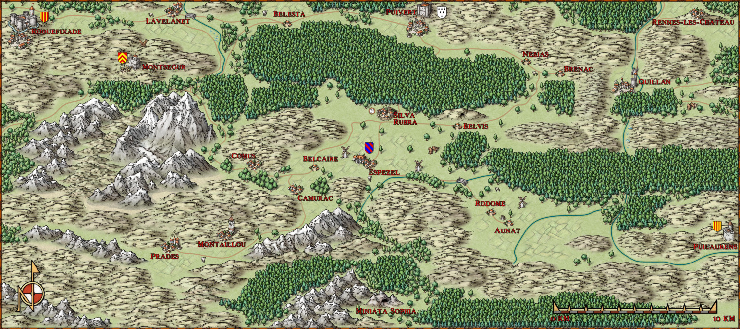
A few years after the first map for my Ars Magica saga, this map is the second one, a detailed view of the area around the village of Espezel, near which the covenant of the Mages is located.
The saga starts in or shortly after 1205, when there is still some years of peace and quiet ahead before the Albigensian Crusade starts. In the center is Silva Rubra, the players covenant (a place where a group of magi live together). Just to the north is the village Puivert with it's castle. In this castle resided Bernard de Congost at that time. In reality, he was a Cathar, and a famous gathering of troubadours was held in his castle. I do him some injustice in my story, and let him be devoted to the study of demonology. In the great forest south of the castle, the players will meet some fairies (no big surprises here). My version of the little village Espezel got a manor house, where Roger de Montaut lives, a vassal of Bernard. The latter is messing with the fairies in the forest for personal reasons. Way to the south, there is the covenant of Miniata Sophia, situated in a vast cave system. Another covenant of wizards, that close? Sounds like trouble. A little to the northwest, there is the village of Montaillou, where some of the last cathars in the region lived. The lavishly preserved inquisition files, compiled on behalf of Bishop Jacques Fournier, with all their details about the everyday history of a village were a stroke of luck for historians. People at that time judged it differently. Even further to the northwest is the inaccessible summit castle of Montsegur. Almost 40 years after the beginning of my saga, this fortress will fall after about 11 months of siege, and more than 200 Cathars will burn at the foot of the mountain. Roquefixade belongs to the estate of the belligerent Count of Foix. Raimund Roger was one of the most bitter enemies of the Crusaders. In 1215, at peace negotiations in Rome, he pounded the Pope that his only regret was not to have slain more Crusaders. In the opposite corner, on the top of a hill, there is the village of Rennes-les-Château. Made famous by a book about the Holy Grail and an invented secret society, a wide variety of treasures believed lost are sought here to this day. In vain, of course. Far to the south of the village is the castle of Puilaurens, belonging to the kingdom of Aragon. It's king, Pedro II., canonized by the Pope after his victory over the Moors at the Battle of Las Navas de Tolosa in 1212, will be slain by a crusader at the Battle of Muret in 1213 when he leads his army to the aid of the besieged city of Toulouse.
A question regarding the hills. I didn't want to use contour lines in the map, but only symbols; but now it is so that there are many higher plateaus in the region in reality, which I could then only represent by an enormous amount of hill symbols. I kept asking myself whether less might be better here.


![[Deleted User]](https://secure.gravatar.com/avatar/c75d9a245b74d9c59be0999ea81ca541/?default=https%3A%2F%2Fvanillicon.com%2F92add7f8c954488718110edc4896ad39_200.png&rating=g&size=200)


Comments
Lovely map, Prochaska :)
You could use a subtle form of coloured contour by adding a sheet with a small Blur effect on it and drawing polygons of 'Solid 10 Bitmap' fill if you feel the need to make higher altitudes paler, perhaps?
Alternatively, you could try making the higher hills somewhat larger in size, perhaps, or possibly use some smaller mountains to represent them instead.
As Sue said though, the map looks splendid anyway!
Thank you two for the advice!
I will definitely try the polygons with the blur effect next time. I have tried varying the symbol size, but that didn't help me with long plateaus or other terrain that didn't fit the shape of a normal hill.