

Dialogue Concerning two river systems

TL;DR: some random notes while trying to improve my process for drawing rivers using the Spectrum Overland annual style.
—
I started this out as a small scale mapping trial while working on my continental mapping project in the Spectrum Overland style which I’ve been undertaking for the last year.
One of my biggest challenges I’ve found as I’ve worked on that has been to find a balance of river styles which:
- Is quick to draw and modify in early stages
- Looks pretty enough that it can be printed at a high enough quality and hung up in my study
This represents my attempts at both techniques I used to date, and in doing so the discovery of a variant which looks like it might be what I need. I’ve turned this to a forum post in the hopes someone might have something better to point me to, or at least something different for me to try at some stage.
—
Caveats:
- This map below was thrown together in less than an hour, with certain features exaggerated and some parts ignored to focus on refining the riverbank modelling, not much else has been given consideration
- My D&D world has a planetary ring around it, and I’ve tended to default to using Spinward/Leeside when describing direction rather than east/west.
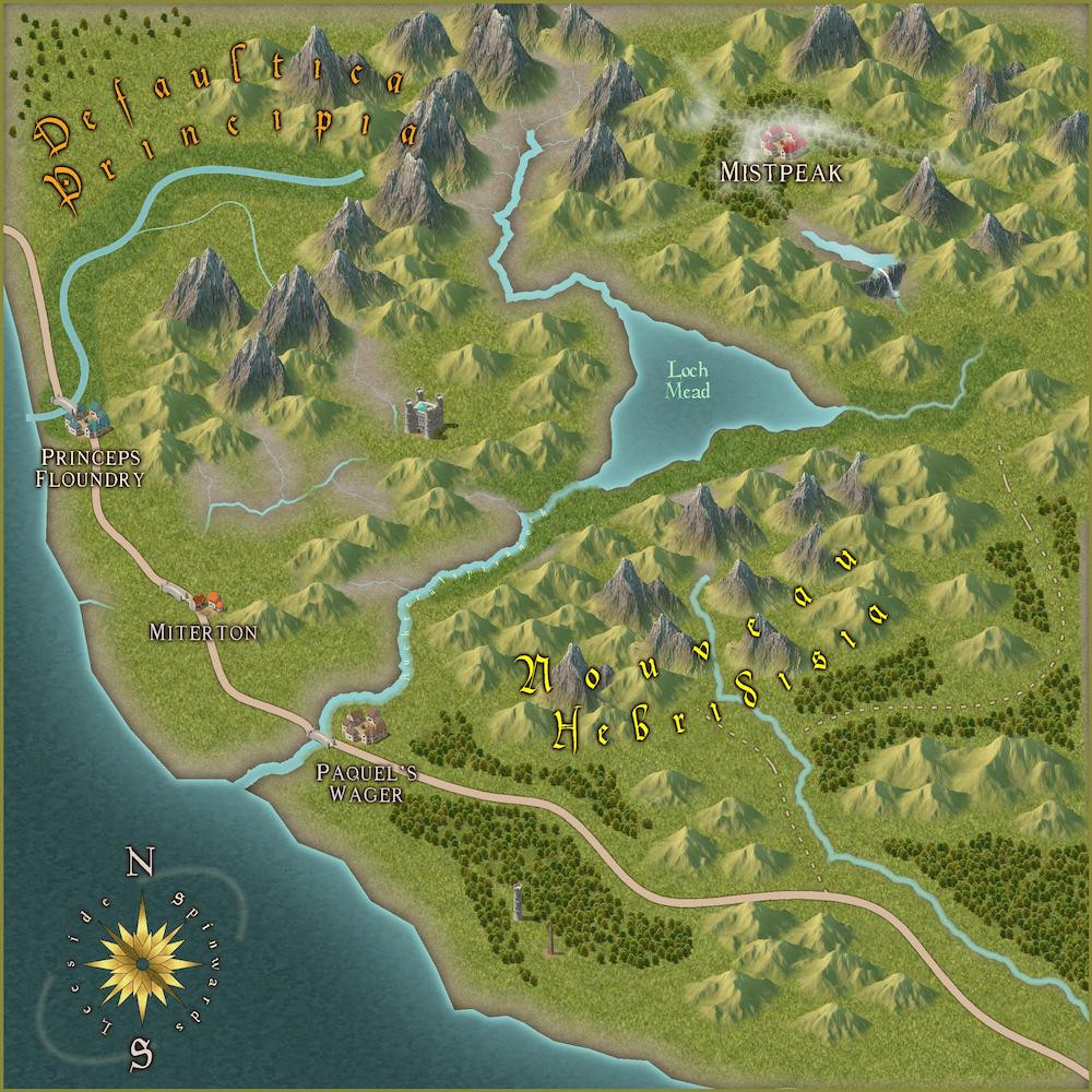
Defaultica Principia:
Technique:
- Use of the standard default river and narrow river tools within the Spectrum Overland annual
- Runs from the mountain range in the North to the Leeside coastal town of Princeps Floundry
- Underlay the river terrain on the following sheets:
- Terrain Grass - Normal
- a large wide poly tracing the Leeside coast and spanning to the Spinwards mountain range
- it stops just below Princeps Floundery in line with the mountains
- Terrain Grass - Rich
- Tighter poly of rich grass which hugs the shape of the river and tries to represent a fertile riverbank
- The blend isn’t quite as smooth as I’d normally do it as I’d tightened the map units on the fade effect while experimenting with the next technique
Pros:
- Can very quickly get a smooth river representation in place
- Allows quick representation of the fertile area of grasslands
- Simple to extend with smaller tributary rivers as can just add new rivers above the existing grasslands
Cons:
- Feels a little too smooth for my taste
- I have normally dealt with this by using the Spectrum Overland Lake tool and drawing a fractal river path, but I’ve found pros/cons to this and still suffers the next issue
- Blending with the sea at the coast
- This is probably what I’m least satisfied with in this technique
- In this case I’ve deliberately overshot the coastline to highlight the issue, but even when matching it cleanly there’s still a loss due to the Land sheet’s blending effects not looking quite natural
Loch Mead and Miterton Valleys:
Technique:
- Takes inspiration from the Island Chains annual and uses a magenta Colour Key to punch the rivers out of the land sheet, and uses a fractal river/lake to achieve the river shape
- River width - 2.0
- Narrow width - 1.0
- This gives the glacial valley effect with many tributaries above Lake Mead but is a challenge to actually add any underlay when many small tributaries
- Riverbed on each side of the Miterton valley is achieved by tracing the river or freehand sketching polys around the river
- Terrain Grass - Normal
- Tracing the main river and stopping when it hits a tributary
- Freehand sketching poly on other side of it with enough space to create a gap in the poly when rendering sheet effects, but this leaves quite a few areas where the riverbank looks arid
- Edge fade effect adjusted to 5 map units
- Terrain Grass - Rich
- Didn’t have the heart to even try adding a rich grass effect here after seeing the edge fade headaches
- Terrain Grass - Normal
Pros:
- Very easy to quickly create river system and tributaries
- Dont have to worry about using the lake tool in a parallel fashion to create nice looking fractal paths of varying widths
- At least without having to resort to a macro
- Blends very smoothly with coastline next to Paquel’s Wager
- Combines nicely with waterfall symbol effect south of Mistpeak
Cons:
- Because of the use of the Colour Key punch effect, terrain effects cannot overlap the river and must work around them
- This means when adding any new tributaries or altering a river course, all the terrain around it must alter to accommodate it
- When tracing a river on both sides, the central point acts as the trace source rather than the outer edge of the river
- This means that when doing both sides of the riverbank the two polys end up touching and joining together when rendering layer effects
- You can see this to the north of Miterton, or below the waterfall at Mistpeak
- When using an Inner Edge Fade effect, if its too wide in its affect it this leaves quite a few areas where the riverbank looks arid as noted above, but tightening it will affect the whole map and might ruin some other nice blending effects (e.g. Grass Normal -> Coastline)
I did have a few goes at trying to trace the outer edge of the river width rather than the center, e.g. tried use of the Offset tool to try and trace a set of parallel lines on each side of the river but that inevitably felt like more work to achieve the effect than felt warranted.
Nouveau Hebridisa:
I had intended just to use a combination of the above two techniques and accepting each of their limitations and using each to their strength, but I felt my greatest pain point was the fact the central line trace would wash out the river, that led me to experiment with this:
Technique:
- Draw river using the Magenta Colour Key approach cutting out a section from the land
- Create two new sheets:
- Riverbank A
- Create two new sheets:
- Edge Fade Inner - 1 unit
- Riverbank B
- Edge Fade Inner - 1 unit
- Trace the outer edge of the coast as with the Defaultica Principa technique,
- preserving the slight edge fading as it reaches the coast, but stopping a few map units from the southern edge of the river
- Switching to Sheet Riverbank A
- On this sheet trace the southern edge of the river and then overlapping enough of the previous poly so that I’m satisfied with the blending
- Switch to Sheet Riverbank B and repeat but on the northern riverbank
- It doesn’t actually matter which if the two sheets you use for each side, as long as you do alternate between them
Pro:
- Tighter edge fade effects are constrained only to the immediate vicinity of the river system
Cons:
- Still requires any changes to the underlying river structure/new tributaries to be propagated to the other terrain objects
This might seem totally obvious to the more seasoned cartographers amongst you but I’m not sure how I missed it to this point.
I’m coming to the conclusion that one of the best techniques I could come up with would be if it was possible to propagate a Color Key effect up through multiple sheets before hitting a “consume” point where it stops propagating, that would mean the terrain wouldn’t need to be altered if adding new rivers (and would be better than cloning the same pattern across all sheets you wanted to cut through). That’s an experiment for another day though, for now I’m going to see how well the alternating riverbanks turns out on a more ambitious project.
——
Below is a tiny extract from my continental map where I’ve followed that 3rd approach. Punched existing rivers made using the lake tool through using a Colour Key and applying the alternate sheeted riverbanking. It actually turned out not too slow to apply, but I will be writing a macro at some stage to switch between layers and setting up the grass tool.
The following uses just those same two sheets, but I’ve managed to alternate my use of the Sheet A/Sheet B to model quite a few different tributaries/valleys.
I also added an Inner glow to each of the two sheets in a different colour as a drafting tool which is missing in this final export. This was to help me remember which side of the riverbank was on which sheet when drawing so that I didn’t catch myself ending up with a unified polygon which washed out the river and having to track it down again.


Comments
Your images aren't displaying for me. Not sure why - might be too large for the Forum, or some other problem. This Forum topic has notes on posting images here, which may help.
Thanks, had read through that first and had followed the advice and seemed to post ok.
Have tried reading them as attachments again and they seem to be ok for me, so fingers crossed.
The images loads fine for me....
They weren't loading to start with, but now they appear to be ok.
@CeeJæy A method you might not have tried is to draw the river as a line, and then cut it into sections along it's length and use Change Properties to gradually reduce the width towards the source. It takes a little time to do if you have lots of rivers but the effect is genearally well worth it. The more sections you cut it into the more gradually you can change the line width and the smoother the outcome.
Thanks @Loopysue, I haven't tried out cutting a river and shrinking it, I've tended to do in smaller sections gradually growing them bigger in a similar fashion, I guess it would result in the same effect.
I'll give that a go though and see if that feels less laborious.
A lot depends on what you want from the rivers. In the second image, it looks like you used the lake draw tool for the river. That will give you a different look than the river tools.
How I do rivers, and it may be more time consuming that you want is the following:
Yes, the images seem to be fine now, but they definitely weren't yesterday! Even clicking on the image symbol brought up error messages, after several reloads of the topic, so I've no idea what was happening!
Rivers are, as has been pointed out by others here already, always a tricky subject, and it does come down to what you want from them, and how much work you're willing to put in to each map.
For instance, you can always add hand-drawn polygons along the lines to vary the width more, or help disguise features such as multiple river confluences, or where there's too great a difference in appearance between two stretches of river otherwise.
River mouths at the coast are often difficult as well, which can be overcome sometimes by moving the end of the line so it blends better with the effects along the coast (where that's an option, naturally; best to zoom-in very closely), or again add a polygon of appropriate size and colour to hide the river line end.