

Community Atlas: Embra - Constructed Places
 Wyvern
🖼️ 293 images Cartographer
Wyvern
🖼️ 293 images Cartographer
The last set of Embra "Places" maps is that for the Constructed Places of Interest, linked from central segment 7 on the "Official Guide" map:
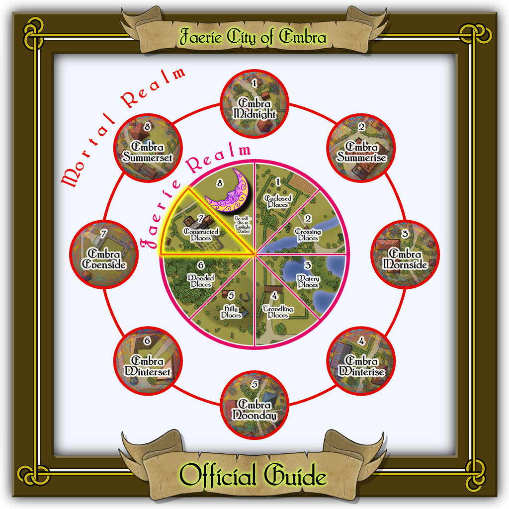
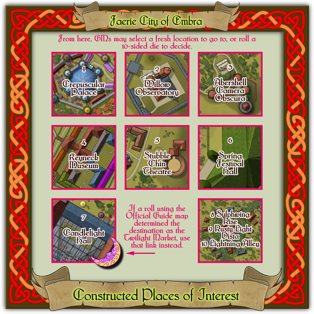
This is the busiest set for individual locations of any of the Places groups, with seven, leaving a mere three to be condensed onto the eighth "Streets" map.
The Celtic knotwork border was adapted from one in the, by-now-famous, Dover Clip-Art "Celtic Borders on Layout Grids" book, providing a completely connected square, to complement the original circular design used for the Village maps. That seemed an appropriate method of "book-ending" the entire set, as well as tying-in with the idea of both being constructed places, if of somewhat different sorts. In altering the design from what had been a vertically-elongated rectangular one to the required square here, I discovered when looking at the finished piece with its colouring, that I'd accidentally produced an asymmetry in the patterning. I did wonder briefly about amending that, but liked the look of something slightly off-kilter as apt for a Faerie setting, and so left it. The hours of effort it would have taken to change it had, of course, nothing to do with that choice...

![[Deleted User]](https://secure.gravatar.com/avatar/c75d9a245b74d9c59be0999ea81ca541/?default=https%3A%2F%2Fvanillicon.com%2F92add7f8c954488718110edc4896ad39_200.png&rating=g&size=200)


Comments
Constructed Places map 1 is that for the ruler's Crepuscular Palace at Embra. Well, I say "ruler", but she's actually more the physical embodiment of Embra made magically real and living, The Verdant Sorceress, who flies on wings made of summer flowers. Something like the Archfey of D&D, though really more like the deity of/being who is Embra in power and abilities here. The name and flower-wings came from random rolls using tables in A Wanderer's Guide to the Feywild, by Heavenly Spoon, available on the DM's Guild download site (Pay-What-You-Want). The rest is more "me", however. I'd added some details to the PDF and text files for the Crepuscular Palace map before I realised it would be feasible to provide a CA3 drawing of the Sorceress for the Atlas as well, something that needed quite a bit of late revision of both texts and the Palace map. Although there wasn't space to add the full CA3 drawing to the Palace one, I did want to add a suitable link-spot by it. So this is the final Palace map:
And this is the lady herself:
Of course, this is only how she appears in her Elf-like humanoid form, when out and about meeting people, and not trying to terrify visitors unnecessarily. She could seem equally to be anyone else in Embra, or anything at the city - such as a flower, a shrub, a tree, a building, a pond, a floral meadow, a path, a hill, a forest, a cloud, a rainbow, colours in a cloud, the River Clack, or a blade of grass. In a real sense, she IS Embra, in all its aspects, positive and negative. (Oh, and this means the final tally of Embra drawings for the Atlas is now 58, not 57...)
Those who've been following this lengthy series of posts regarding my Embra mapping closely may recall the Palace Heights map among the Hilly Places, and spot the resemblance to this Crepuscular Palace one. That would be scarcely surprising, as they're the same place, here with the Palace a living, still fully extant, building, rather than grassed-over ruins. With an interior:
However, the interior is shown only for the ground level. The upper storeys - which all the towers, walls and great central dome have - are left for GMs to determine, if required, as the elements in it change from time to time.
Place 2 is the Willow Observatory, inspired loosely by the real-world astronomical observatories at Edinburgh, Royal Observatory Edinburgh (which is some distance from the city itself) and Calton Hill Observatory, which is right in the city centre, and the consequent long tradition of watching the night sky from there. While some of that tradition was used to inspire what happens at Willow Observatory (including the annual summer activity of looking-out for dragon ghosts in the all-night-twilit northern sky; you'll have more luck trying a search for "noctilucent clouds", should you wish to learn more before the PDF and text files are available), the setting is purely Embra, as the misty marshes and woods nearby would scarcely seem conducive to dedicated sky-watching if anywhere else. And who knows what you might see on the planets of the Nibirum Solar System using one or other of the great magical telescopes here:
Building interiors:
And the upper interior floor for the Gatehouse:
Plus there are oddities nearby, all of which receive at least some discussion in the accompanying notes.
The third Constructed Place is the Abershell Camera Obscura, set in an apparently unlikely open zone, more suited to an observatory, one might think:
As ever, despite the random selection of base-maps for this series of drawings, the choice of what went where was solely my own, all of which decisions were made with the aim of providing additional puzzles for anyone trying to explore the city, when working to ordinary (i.e. non-Faerie) norms.
There are just two actual buildings here; the rest are open domes over the paths. Oh, and for those who might be interested, the Shelly Tearooms are famous for their exquisite range of ice-creams:
While the Camera shows views of the surrounding scene from its darkened inner chamber, as might be expected, under the care of the featured text's magically-skilled Water Faerie operator, it can show many other things and places too. And when you step out the door, that might be where you'll be. Only if the scene changes, the Camera building won't be there to take you back...
Next is the Keyneck Museum, full of wondrous artefacts gathered from across Nibirum and beyond, with displays that change from one visit to the next, although there seems nowhere here to store whatever isn't currently on show. Key Beck might intrigue visitors as well. The water flows in along the west side of the channel from the southwest, round the circuit of the Museum, and then out again down the east side of the channel. Narrow, isn't it? And maybe the name relates to the layout of the Museum buildings in relation to that channel. Possibly.
The fifth Constructed Place moves us into the "entertainment" quarter (if Embra had such a thing, at least), the actors' village of Stubble Chin Theatre. Subtlety isn't really in it, with Sorceress' Hill and Verdant Wood adjoining one another, but theatricals often feel the need to make a clear statement, it's said...
The Theatre itself is an open-air one, though it has a concealed clamshell cover that can be raised to move everything indoors when required, allowing for a greater variety of performances, not necessarily all of a theatrical nature.
However, the sixth built Place is one more suited to indoor musical performances without such adaptations, Spring Festival Hall:
The bright green roof tiles are all made in the shapes of unfurling, fresh, spring leaves, to contrast with the walls and ceilings of the Hall, that bear relief-carved autumnal foliage instead (Embra; what else would one expect by this stage?).
Inside, only the layout plan for the surface-level is provided. Most of the towers have higher, and lower, floors too, which are not illustrated, and which also like to change at times, as the accompanying written notes indicate:
Folding doors allow performances to be enjoyed outdoors on The Plaza or in The Garden, while the Mobile Stage can be raised or lowered to allow more seating in the Grand Auditorium. Despite its odd shape, the internal acoustics are excellent. If you want to perform here - and have the skill to do so - it might help to have befriended some of the musicians from Glass Harmonica Way first (see the Watery Places Streets map). Plus of course, any excuse to use some more of Sue's wonderful red sandstone cliffs!
Last of the individual sites is the Twilight Market setting for this group of Places, Candlelight Hall. The Hall has a huge, pale-blue, glass-tiled roof over much of it, and while that was straightforward enough to draw - CD3 tiled roof shaded polygon with added Sheet Transparency Effect - the support structure took rather more thought and effort, albeit "Trim To Entity" does work wonders in cases like this, for all those roof beams. The view complete:
Even this view indicates the interior had to be quite heavily detailed while the roof was left in place, and for once it was prepared normally with fills and symbols, not just the cream-and-green plan sketches all the other Embra interiors have received. The "normal" image above does allow the focus to be a little more on the scatter of other stalls and tents outside the Hall itself, before plunging inside. And so to that interior:
Peering closely suggests there are a lot of windows piercing the walls, all narrow, high, point-topped, and painted with a great assortment of subjects and scenes, which with the huge see-through roof area, means that at twilight or in the dark, the lights from inside shine out like a beacon from here, partly hence the name. And just in case you couldn't guess, Smokin' Mona's is THE restaurant for this part of the Market.
Comparing the two views here, one other element becomes clear. The internal labelling can be turned on or off separately to the other map labels this time. If all goes to plan, that should be via toggles in the Atlas' FCW version.
Thus, and somewhat appropriately, we reach the end of the long road of all these Embra maps, with three more roads. Or "Lanes" from the map's title:
I'm sure I don't need to mention why Red House and Grey Park at Sylphwing Rise don't have roofs that match their name-colours, or why there's both a Wyrd House and a Wyrd Hall (which folks are forever getting mixed up...) along Rusty Light Vista - the latter probably the oddest shape, with its turnings and cross-streets, of all my random street designs in the city. That's randomness for you though. I should point out, however, that those little grey-white dots scattered around Rusty Light Vista are the "large reflecting spheres" of its featured text.
Lightning Alley is just - spooky. All the properties here appear to be deserted, and are each covered with a huge, dark, thick rubber sheet, fastened down so nothing can get in or out. And those blackened scars are from lightning strikes. And it's a cul-de-sac, so why would anyone want to come here? Faerie might be full of wonders, but they don't all have to be pleasant ones...
And that, my dears, is, as they say, that! I'll probably be mapping something else in Errynor by now. If I've found my way out of Embra, that is 😉
As usual, more than awesome. But my favourite is the character portrait.
Thanks very much everyone!
And on Quenten's point, the odd thing is the Character Artist portraits take hardly any time at all, by contrast to other types of map.
It is a shame that Character Artist doesn't get the same kind of updates and additions other parts of the CC3+ program suite do; some variant body and face shapes would be interesting, for instance, though I appreciate that would add a lot of extra work, fitting the various costumes and weapons, etc., to such alternate forms. Still, if you don't ask...
I fully agree ! More variety in Character Artist 3 !
And finally, the final set of Embra, the Constructed Places, are now in the atlas. Thanks to Wyvern for all these great maps.