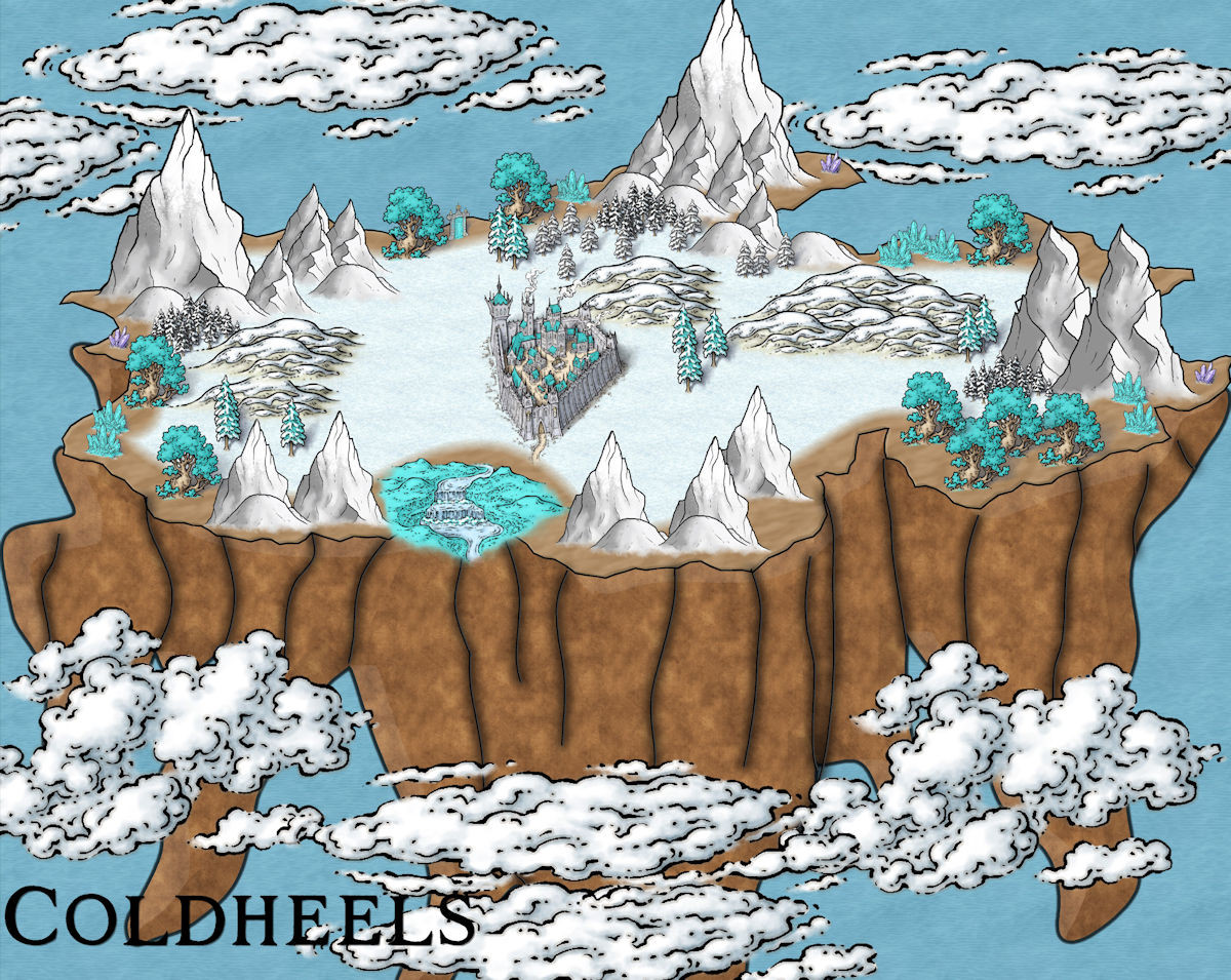
A Quick Stab at a New Map
 Kathleen Ann Cox
Surveyor
On the spur of the moment, I decided I wanted an adventure to start out in a city in the clouds. So here is my first attempt to fake it.
Welcome to Coldheels.
I got the inspiration for this map from a few symbols in the Erdan Annual and other similar cities I have seen.
Everything was done in CC3. Symbols are mostly Myrk and Schley. It's the old sea background :). Once again, I think it has potential, but I am actually trying to write up the story and plan the encounters, so I am trying not to obsess about the map.


Comments
I have no idea what I am doing, but I know that I want my cloud city! So here is stab #2.
So here is where my brain is going with this map. It used to belong some giants and the crystals are what keep it airborne, but the crystals are fading ... Uh-oh.
we need floating islands :D
So here is the latest edition of Coldheels.
If this map would make a good contribution to the community atlas, I'd love to add it. I am pretty sure the map was done completely in CC3+ using assets from many catalogs, but I need to go to that thread and check out the process for submission again. Unfortunately, I have used a very slap dash method for putting it together and should probably do a lot of clean up work before I put it out there for anyone else to use.
Would love to see it in the community atlas. As I see it, there is just one minor hitch, there isn't any overland map that contains a spot for a floating city like this. I feel it would be a bit weird to just link any random city on the map, so I guess the challenge then goes out for anyone to make a local area map in an available region in the atlas that contains a suitable spot. (The March 2021 annual - Erdan worlds overland style has floating island symbols.)
[Of course, maybe there already is a suitable map out there someone can point out, I can no longer remember every map in the atlas]
Well, it could be a floating city that never stays in one place. No idea how that would be handled link/hot spot wise though.
I do have a number of Cloudland areas in my Errynor maps on Alarius, which have floating settlements of various sizes and types in places, although they're cloud-based (buildings as well as the supporting structure), so the rocky base and "real" buildings here would need some additional explanation, though that wouldn't exclude it.
The downside is I'll not be mapping any of those areas in more detail any time soon (already committed to the next of the 250 x 200 mile maps from that region, for instance).
For Jim's idea of a floating city, maybe something like what I used for the Summer Palace of the Winter Queen maps might work? That used a limited list of random places the Palace might appear on any given day, with a sketch map of the world.
Another possibility might be somewhere over the high-magic-using continent of Kentoria. Not sure any of the three more detailed areas done so far would be suitable, though it couldn't hurt to check. Or maybe it could simply float from place to place above Kentoria?
I don't want to complicate the atlas. If it doesn't fit, I am okay with that. In my mind, this is almost like a spelljamming place. It definitely is mobile, but it can also be teleported to other planes. It is the home base of a guild of heroes who travel to deal with major events throughout the multiverse. Of course, none of that is canon or true about a submitted map.
Best,
Kat
I'll get round to doing and Erdan style map just for this - will be about a week though as I have a very full week this week. I will probably place it in Galahais
I suppose I should wait until Quenten has a chance to finish the Erdan map before I put in a reservation on the community atlas thread. My plan is to go back and simplify the map in a few ways. I don't think I need every style I included in the map. I grabbed assets from different vegetation/tree, structure, and mountains at the very least--some with shadows and some without. I even pinched a few items from perspective and dungeon styles.
I debated whether to use both the flat overland structure styles and the more isometric styles and finally decided I was too attached to the the Myrklund style to cut it. In my head, I was able to justify my map oddities because of the points of origin of some of the assets (like some of them brought their own shadows with them from their native planes).
Anyway, I probably be testing out a few versions for critique here before submitting the final atlas version.
Very cool (pun intended) map. @WVFaeryWoman I can particularly relate to your "I've no idea what I'm doing" comment in an earlier post...
Hi, @WVFaeryWoman I have pretty well finished the map for your Sky City - let me know if you want anything altered, (and room for 2 more Sky cities, everyone).
A new version of the flying island city map. Okay, let me have it! What do you like? What do you hate? What makes you say what the heck is she doing now?
My obsession with water basins in this map comes from the lack of rivers and the idea in my head that most water has to be collected from rain. I also have this idea that there may have been volcanos in this area before it was lifted from the mountain top and disconnected from the molten core of the planet. I think the soil on the flying island might be toxic and leeches into the water over time so the basins have to be drained periodically so they have to have a rotating system to have fresh, drinkable water. The island originally belonged to cloud giants who used it to raid and plunder like a ship, so there are huge ruins scattered over it. I have a notion that the crystal engines were fueled through magic and the death of gem dragons caught and fed to the "machine". No gem dragons have been captured or killed since the guild took possession of the island so the crystal supplies are running low. The people of the city need to buy or trade for most basics because of the poor quality of the land (which means I should probably rethink the vegetation in the map). The city is the haven and refuge of a family and then guild and then a whole town who had to flee from their homeland and relocated their entire community to this flying island.
On the water problem issue, given the city is literally up in the clouds, they may have developed a way to get the clouds to condense at specific sites (effectively as fog), where the moisture can form up directly from the clouds without having to rain, and then run away to collection areas.
The flora of the Pacific coast side in and around the Atacama Desert in Chile might be worth looking over to see how the plants cope with catching fog-water to live by alone, perhaps. Possibly each building would have its own "fog catcher" system for water, maybe magically augmented. That would always be fresh, of course.
Might be worth laying-down the giant ruins everywhere first so the roads will avoid running into them. The road network seems a bit too uniform for that currently, as if planned like a modern city.
The drop shadow to the upper-left makes everything look really flat in the plane of the background image. It's tough to get something like this to read well purely using effects in CC3 because the shadows aren't simply related to the top surface. Putting a sheet right below the top surface layer that contains darker transparent polygons might work, but then you'd need to draw the shadow areas manually (not something that I've ever been able to do well myself).
On the crystal engines, are those little platforms on to the side of the lower areas or are those cutaways to show the engines inside the base?
As Wyvern points out, any tall building could be considered as a way to claw water out of the clouds. You could also put some sails (like crab claw sails) or sail-like things along the edges or in the higher areas to directly collect droplets. Niven's Ringworld (the second one, I think) book used a cooling system on shiny areas of buildings to condense water for a floating city even without direct cloud interaction. Peruvians harvesting water from fog | Sustainable Footprint may also be interesting.
In addition to looking at the Atacama for examples of fog-based survival, look at the Namibian desert. The native Welwitschia mirabilis is a great example of an unnatural-looking thing that collects its own water from fog. It also demonstrates the idea that just two leaves is sufficient for a plant to survive, given the right conditions.
From an aesthetic viewpoint, I prefer the darker brown "base" (the supporting earth/cliffs) from your first map to the much lighter color of the second one. I think it's the contrast between that and the surface area that appeals.
I agree with Maidhc that the first map is better - well, so far anyway.
Water storage - a depression in the rock of the flying island to act as a lake-reservoir.
Food - vertical farms, high rises with vegetation everywhere. And glasshouses to protect against increased turbulence at altitude.
Don't give up on what you have, though. You could follow Joe's advice (jslayton) quite easily by copying the basic shapes (not the details) from the mass under the island to a new sheet just above that, then change properties so that everything on that sheet is solid black, you can then add adjustable sheet effects to make it blend transparently and turn everything several shades darker.
I recommend using a Blend mode, set to multiply or overlay at about 20% opacity.
I just wanted to touch bases with the community with an update. I have been dealing with some health issues related to arthritis and disc degeneration so I haven't been able to spend much time at the computer. I am feeling a little better but this has slowed and paused my progress on this project at the moment. I hope to get back to it soon.
Kat
Good luck !
@WVFaeryWoman I have finished the map for you and it is in the Atlas (Doriant - Galahais - The Morstarik)
I hope you find an acceptable remedy for the pain soon, Kat.
Best wishes.
Thanks everyone. I guess my back is more messed up than I realized and they may recommend surgery as one of the treatments, so my map is probably going to be put on hold indefinitely. I think I claimed a spot in the atlas and I hope to fill it, but I will post there too about the possible delays (hopefully not cancellation--I love mapping!).
Regards,
Kat
The best of luck in getting it sorted out, Kat.
The mapping will still be here when you recover :)