

Eden, NSW
![[Deleted User]](https://secure.gravatar.com/avatar/c75d9a245b74d9c59be0999ea81ca541/?default=https%3A%2F%2Fvanillicon.com%2F92add7f8c954488718110edc4896ad39_200.png&rating=g&size=200)
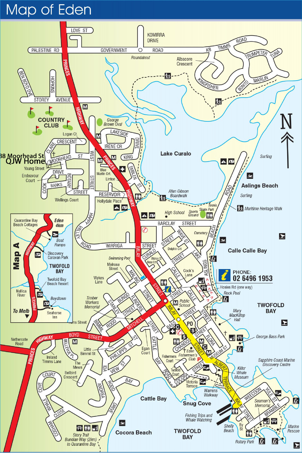
This is a city map of Eden, done on Modern style, and also in a medieval style, both destined for the Community Atlas. Eden is where I now live. I am using the Modern Road and Street maps for the modern map; and not sure which I will use for the Medieval map.
Comments
Progress
Streets, Highway, tracks and coast done
Text, parks and landmarks to go, then on to the medieval version
Text done.
Nice tidy job on that one :)
Finished. All but the photos will be put into the Atlas somewhere.
Now onto the medieval version.
Here is the map for the Atlas. It will be sited in the Irisian City States in Artemisia, so all the names have been, roughly, translated into Greek. In addition, I have added some remnant ruins of walls and castle, so they will definitely appear in the medieval version. And all the churches are of course, temples.
Larger version in the gallery
This is an interesting take on the idea of RPG mapping for a fantasy setting. Might have been still more intriguing to have adapted the rest of the modern tourist information symbol meanings to something more fantasy though.
Point taken, and I will think on that - sounds like a good idea, though. BTW, the vector symbols I have drawn are available to ant who want to use them - I will put them in a folder to download later on.
Hadn't realised the symbols weren't part of one of the modern mapping Annuals. I've not really done much with any of those (caves and shallow undersea excepted). Presumably there'll be a CC3+ symbol catalogue of them in the Atlas eventually too?
Sure, I am happy to share all the vector symbols I myself made.
A Medieval version of the city of Eden/Sokranom. Not finished - vegetation and street furniture to add, and text labels. I have put a large version in the gallery so people can better see and criticize my inevitable mistakes.
Looks very good so far.
What is the main style you are using? Think I can make out Symbols from City Streets, Cities of Schley and Darklands. Is ist Fantasy Town?
Didn't see a lot of mistakes at first glance. The light green terrain at H3 could need some effects
And the farm animals are as large as some buildings - but it might make sense to draw them big, so they don't just show as tiny dots (or not all) if the map is not enlarged.
The modern version is great, too. :-)
Very nice mate. Great idea to use a real world example! Now you can start on doing the same for regional towns in Victoria. 😉
Victoria? Is that a real place. I'll stick to the original State thanks. 😁
OK, I have completed the map sans text. I would like comments please, so I can submit it as soon as the text is done - streets will be marked on the streets themselves, buildings on a key. I have to give a bit of thought there to the names.
I have also place a larger version in the Gallery.
Especial note to @Wyvern and @DaltonSpence - my best critics. ❤️
Map's looking good.
The fill on the frame seems a bit "linear repetitive"; not sure if that's deliberate, though it is mildly distracting to my eye.
The northerly coastline where there aren't any broad beaches or cliffs looks a trifle abrupt. Might be worth considering adding a thin "beach" and/or "rock platform" outline polygon along it (polygon rather than line to look a bit more naturalistic).
Assuming the frame's alpha-numerics are going to relate to a final map key, there'll need to be a suitably pale grid over the map as well to clarify where places away from the frame actually are. It may be worth considering having both that grid and the letter-number frame labels, and maybe even the final key listing, on a sheet that can be hidden, as currently they look rather too modern in style, and the grid's going to be a distraction more generally, if added.
Okay, thanks Wyvern. I will change the border to a thinner one, without the numbers and letters, and just use a typical key with either letters or numbers.
I will tinker with the northern coast. As you may not realise, this is an accurate coastline of my home town, and the area above does lead into fairly marshy land on the northern lake, but a rocky platform on the northern coast, so I will add that. Also I am thinking of adding a murky transparent fill over parts of the lake where I have the algae and scum. It really isn't there now, but I am putting it there in 'medieval times' (not that Australia had these).
I knew I could rely on you for useful advice. ❤️
OK, here is the final version, barring any comments and advice for changes. Again, a callout to my favourite reviewers. After a few days, I will submit this to the Atlas. Another city done. Just 2 more - the city of Skolt in Ezrute, and the city of Odesa, renamed of course, to be put somewhere - it will be the largest city I have done - over 1 million people. The Constantinople of Nibirum. And the city centre of Tatiamisto (based on Chisinau, capital of Moldova) and the shipbuilding district of Tartateos in the Irisian city States, and finally, finishing all the district maps of Stromphe - and perhaps getting started in on district maps of Torstan. All these are also important sites for my own world of Myirandios.
Anyway, that is my game plan for now, plus a few map[s here and there just to break it up a bit.
Here it is, the medieval conception of my hometown of Eden. Larger version in the Gallery