

Lakes and Rivers disappearing, tried a bunch of tips from other forums, but it is still happening.
 Briwood
Newcomer
Briwood
Newcomer
So I have created rivers and lakes without any issues in the past, getting back into things though and started a new map, for some reason the rivers and lakes disappear below the landmass. I have looked at different suggestions to create a lake layer, and move the layers around, but everything I have tried still disappears.
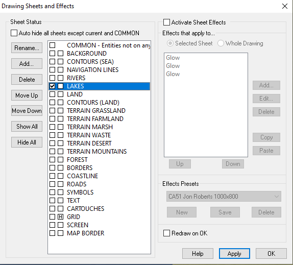
I have a screenshot of my layers, I have tried with lakes and rivers above land, like they are now, and also below land.
Comments
They really are below the landmass.
The sheets are in the order in which they are rendered, which means the RIVERS sheet is rendered before the LAKES sheet, and both are rendered before the LAND sheet. Move the LAND sheet up to just underneath the NAVIGATION LINES sheet and you should be ok.
And to add what Loopysue said, make sure that your rivers and lakes really are on those sheets. They won't automatically go there even if you have sheets by those names, where they go is determined by the setting in the drawing tool.
You can always check witch sheet an entity is on by using the the List command from the Info menu, or simply hiding all other sheets than the one you wish to inspect.
So I have moved the LAND sheet up below NAVIGATION LINES like Loopysue suggested, it is still doing it though. I am not entirely certain what is going on though based on what you said. Last time I used this, I made rivers and lakes and it just worked, I didnt have to change anything.
Does this all look right?
Normally, you shouldn't need to change anything, as the tools and sheets should be set up to make everything just work unless you are trying some more advanced techniques.
Looking at your screenshot, I notice the Sheet setting for the tool is blank. The default setting for that particular tool should be
LAKES*.With that setting blank, it means that CC3+ will NOT attempt to put it on the correct sheet automatically, meaning you'll have to take care of things manually. Basically, that means you need to set the sheet to LAKES manually before starting drawing. I see it is set to LAKES currently in your screenshot, so assuming that your landmass is indeed on the LAND sheet, it should work right now, but if you change the currently set sheet, it will go to that one instead.
If it doesn't, confirm that your landmass is indeed on the LAND sheet, as rearranging sheets won't do a thing if entities aren't on the appropriate sheets.
Basically, use Info -> List on your landmass to check it is on the LAND sheet, on the lake to check that it is on the LAKES sheet, and that the sheet ordering is with LAND appearing higher up in the list than LAKES.
So, I dont understand what Info - List is doing. I click them, but nothing happens.
I did try puting LAKES* in the sheet box, but it still disappeared on me.
I may just restart completely and see if it works...I really dont understand the layers and sheets and how they all work, dont really find the tutorials all that helpful either. I watched a Joe Sweeny tutorial series which helped but deviating from the things he explicitly shows, seems to end poorly for me.
Click List, then pick the river, and then D for do it. You should get a blue box that comes up and tells you what sheet the river is on.
I really wouldn't worry about layers. They are relatively inconsequential right now. The sheets are what control the order in which things appear. Layers are just a fancy way of grouping things. That's all.
Remy did a great tutorial showing how sheets and layers work. It really helped me out visualizing stuff (they used some awesome props!!).
(it's just a privacy friendly version of youtube! You can also just look up "Learning CC3+: Part 5 - Sheets & Layers" on youtube if, for some reason, you do not trust it :) ).
Sam
So I started a new map, the "Land, Default" works properly, but I want the landmass to be grassland, not the ugly brown colour. Rivers and Lakes dont show up on top of the grassland, but as far as I can tell, I have them set the same. On the sheet status page, TERRAIN GRASSLAND is above rivers and lakes, and so is LAND...So shouldnt they still show up on top?
Ok, I dont think this is a "fix" so much as a workaround, but since the lakes and rivers show up over the Land, Default sheet, but not the grassland, I just changed the fill colour of the default, to the grassland which works.
Thanks a lot for all the help, I know it is a basic feature, but it isnt the most intuitive, for me at least. Thanks for the links as well! I will be sure to check out the videos on sheets and layers.
1) Sheet order is important.
Sea
Land
Lake
Is the sheet order to get the lake on top of the land. Same with Rivers. Sea is drawn first, then Land, then lake.
2) To change the fill style from brown to something else.
Go to the Sheet dialog. Click on Terrain, Grassland. On the left of that dialog, click Hide All. This leaves only the Terrain Grassland visible.
Click okay. You should now have only the bitmap fill of the dark brown.
If it vanishes, it is on a different sheet. Show them one at a time, click on Apply; until you find it. Hide the rest of the sheets. Then changefs is what you type.
Click on the dirty brown fill. Select do it form the menu.
Go up to the upper right and click on FS: that brings up the bitmap fills.
Pick the one you want to change to.
Click okay.
It is now the new bitmap fill.
edit:
Make sure there is something on Lake sheet, since you started a new map.
Select Lake sheet from the Sheet dialog, and hide all the rest.
If it is blank, you need to add a Lake.