

WIP - Rust Top Village
 Glitch
🖼️ 33 images Surveyor
Glitch
🖼️ 33 images Surveyor
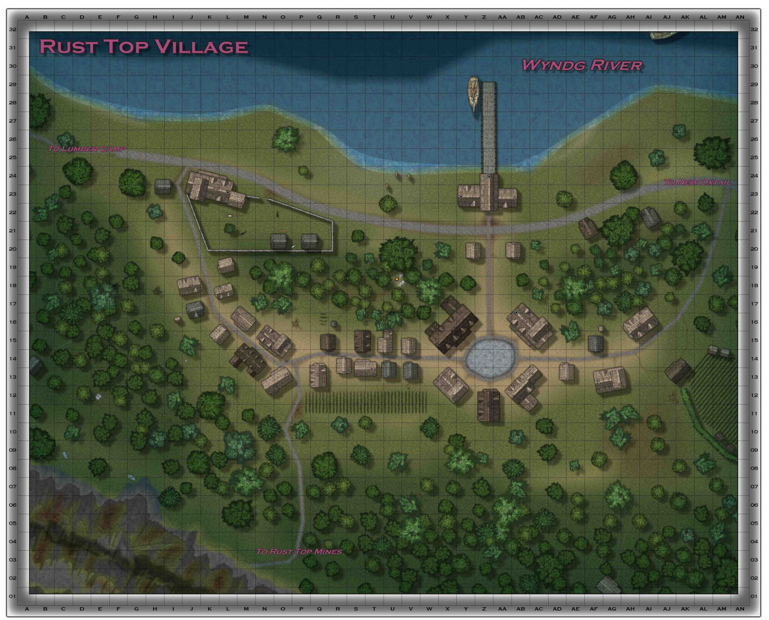
Still working on details - need to decide what to do with the town center; the long strip of "farmland" is supposed to represent Butts (archery range); need to add other misc LOD. Suggestions welcomed as always.

![[Deleted User]](https://secure.gravatar.com/avatar/c75d9a245b74d9c59be0999ea81ca541/?default=https%3A%2F%2Fvanillicon.com%2F92add7f8c954488718110edc4896ad39_200.png&rating=g&size=200)


 and 3 others.
Comments
Looking good :)
I recommend using a Transparency sheet effect on the grid to make it a little less overpowering.
There are better fields in part 2 of DC if you want them.
Looking fine!
Not sure what the scale is - maybe 10 or 20 feet squares, judging by the road widths and house sizes? If so, the archery butts is probably too short at circa 70 or 140 feet long. Medieval English trained archers were expected to hit a target at a minimum of 600 feet with a longbow, and that had to be practiced, of course. However, the butts would be space-dependent, so could be shorter than that (this page, which has a handy synopsis of medieval butts in general, suggests a maximum length of about 200 metres/650 feet, for instance). The area would be marked by substantial grassy mounds for the targets though, so that might be something to think of adding here. It's probably also too close to the houses currently - there are numerous medieval records of accidental archery injuries near the butts, so maybe a screen of trees/bushes could be a possible addition here, as well as moving it a little further out from the town.
For the town centre, an open market place would be a useful addition, perhaps.
Thanks for the input!
Sue - turned off the transparency so that I could document the grid co-ordinates, forgot to turn it back on. Having problems with the drawing tools from part 2, will download and re-install. If that doesnt work, will reach out to tech support.
Wyvern -
Good eye. I've given up trying to have a proper scale when using city - taking a more representative approach rather than true to scale. Great info on Butts - agreed that it was too close to buildings and not quite proportional.
For the town center, an open market makes sense - now to find stalls. Maybe even a public events platform/stage?
Dalton - Great info, had no clue that boats would moor on the down river side. Shortened the dock and moved the ship.
No bridge, other side of the river is wilderness. Someone was watching Alaskan Reality shows and after a glass of scotch, wondered what would happen if you gave grizzly bears the sight, intelligence, and pack instincts of wolves....and then one really bad winter the river freezes over.....
No scale bar - the grid is just to id buildings and locations. But having it there begs to have a scale bar. So going to eliminate the grid and go back to labeling key locations with text.
Here's the changes I was able to put in this morning - the glow on the road ruts in front of the warehouse/docks is too strong, but right now just playing with it.