

Attach option
 Dracus
Newcomer
Dracus
Newcomer
Hello everyone, i've bought a while ago both latest humble bundle CC3+ pack and began recently to learn how to use it, i've been following videos to help me going through like this one :
https://www.youtube.com/watch?v=_HLzmWBhBrk
My main trouble is about the 'attach' option, while it do snap two different ends of road's segments, i've met some trouble about CC3+ not doing it seamlessly :
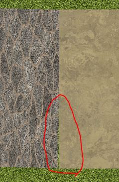
While it is not the end of the world, it begin to be very bothersome when sheets come into play :
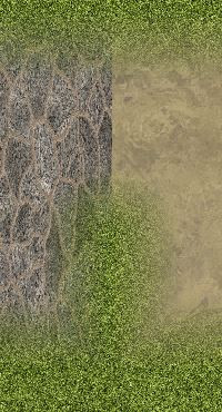
I would love to get a few tips and tricks on how to proceed to avoid or fix this kind of behavior as in the video the person dont seem to run into this quirk.
Thank for the help !
Comments
Attach works as long as you hit the line of the polygon you are trying to attach your new node to. If you miss the polygon altogether it won't attach to anything. It's worth zooming in a bit to make sure you've got the line and not the space nearby.
If you realise after you have drawn the polygon that the attach didn't work, you can still use the move node tool to pick up the wayward point and with Attach still switched on, place it on the line near the node you want to attach it to.
Thank for the reply, i did do right the attach 'part' while using the dirt road on the tips of the stone road, it snapped the middle of it, a bit away from where i clicked so i do assume the attach mode worked, but thank for the tips i will try out or else just find some workaround.
When you are using attach with a line entity like a road the nodes run down the centre of the line, and not on the edge.
I wonder if something is wrong with my CC3+ i tried again, with a new map, with another city setting and i get the same results
it does snap to the middle of the edge of the road and let me continue to draw.
I was thinking it would fill seamlessly by making a round corner around the attach point between the two roads which seem to be not the case and i have to fill manually so either i am not doing it right or i am starting to asking myself if something is wrong with my CC3+ as i tried to makes walls and everything is fine but when i tried to use the cliff from CA165 it just do not work at all (while the pdf guide included for of cliff CA165 explain clearly it is quite easy to make a contiguous cliff).
Am i mistaken ?
Attaching doesn't automatically make corners for you. The only thing that modifer does is to ensure the nodes are in the exact same place, so for your road, it would ensure the start node of the new road is at the exact same point as the end node of the existing one. But line endings are perpendicular to the the direction of the line, so unless the direction of the two road pieces are 100% the same, there will be gaps, which is what you see both with your original example with the effects, and the later one in the last post.
As for symbols, you cannot really attach these to each other. A symbol only have one node, the symbol origin (or placement point). You can attach them to a line or snap them to a grid, but using attach to make them line up won't work.
I think there may be a different issue with the cliffs, which aren't polygons like the shapes and lines you have been trying to align, but bitmap symbol entities.
Are you doing a metric map?
We discovered after they were published that the cliffs don't work in metric maps. They are a connecting symbol and work really well in imperial maps, but since most of us use imperial map templates (including me) I had no idea there was a problem until the first time someone tried using them in a metric map and produced very similar issues as you have with them in that last screen shot. The answer is to create an imperial map and draw the cliff lines you want in that imperial map, then copy them to the metric map in one go, then scale them up all at the same time.
ok, i wasn't sure, i was expecting more than it does, ok, thank a lot and about symbol, ah damn, i am indeed in metric.
Well i will work with imperial and drive with it, it's no big deal, thank a lot and i mean a lot, it's a very nice tool and i dont regret it.