

Changing the way Hexes are numbered
 RatherDashing
Newcomer
RatherDashing
Newcomer
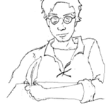
Hello all! I am a brand new user to CC3+ and am trying to figure out how to use it to create a hex map. Eventually I would like to try my hand at making a realistic map with normal coastlines with a hex drawn over top. But to get my feet wet I thought I would try a template with hex shaped terrain first. I am trying to convert a map I made in a browser based program called Hextml. This is how the grid looks in Hextml:
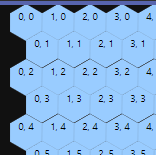
I was hoping to remake the map in CC3+ without having to change all the hex numbers. But I cannot seem to figure out any way to modify the way CC3+ labels hexes. The picture above seems to be a more sensible way: the number increases left to right without zigzagging since the horizontal hexes don't zigzag. Here's the same hexes in the way CC3 labels them:

I'm having a hard time explaining the difference but the Hextml way seems way easier to read to me. Besides that, I've already begun keying my campaign around the labeling system from Hextml. Is there any way at all to change the way these hexes are labeled?
And while I'm here, is there any good guide for brand new CC3 users for making hexmaps? Every guide I have seen seems to assume prior knowledge of previous editions of the software and just explains new features and changes. Where would you all recommend I sart?
Thank you!
Comments
Well, for the hex map you are trying to do, try switching to the other grid style (Horizontal and Verticle). One delivers the jagged wierdly numbered hex grid and the other is more civilized.
Insofar as changing the numbering system, I have not found a good way.
I tend to base my maps on topographical maps. I decide on the scale of the map and the actual size I want the map to print out at (e.g. 11 x 17 inches) and then mess around with sizing the map and the hexes so I get the size I want. usually in is about 5/8 of an inch = 250 -1000 meters of groud, but it varies a lot.
You can search on my name and see some of my maps. If you post an image of one of your maps, it will help others to help you.
Mike
For hex numbering, CC3+ only have the options shown in the dialog. Unfortunately, there isn't a set standard for hex numbering, so various system has been adopted for various uses/various programs over the years.
The numbers are just text entities though, so you can always add them yourself instead of using the built-in command. There's a macro in this topic made for numbering hexes using 3-digit numbers, not exactly what you're asking for, but it shows how you can number them yourself using a macro, and should be able to be adapted to your needs using some minor modifications
Thanks for the help guys. I think for this one since it's relatively small I might just add the text manually (there's only 23x19 hexes). I'll try doing it horizonal next time but I kind of have to keep this one how it is or I'd basically be redrawing it.
Since I started drawing this map as a true hexmap (plopping down one hex at a time to make the shape) I'll stick with this style. Next time I start a new hexmap I want to try by drawing fractal features first and then just overlay the hexes on top. But the problem I was running into was trying to figure out how to draw a coastline that doesn't show the whole continent: as in, using the coastline tool to draw a coastline that goes to the edge of the map and then stops. Every time I use the continent tool it just wants to make an entire continent all the way around so it curves off weirdly if I try to take it up to the edge of the map. Any advice on where to start when drawing portions of a continent rather than the entire thing?
I'm not sure which style you're using to draw your coastline (I'm assuming using the "Default Landmass" tool ), but this only draws a complete polygon, so it needs to be extended beyond your map border as well to make it complete.
Most of the Default Landmass tools have settings that mean ordinarily they won't draw anything beyond the map border, and instead will simply follow the edge of the map border providing you remember to click OUTSIDE the border at each map corner and once more beyond the map border near wherever you started drawing your coastline. That should create the landmass in the shape you're after.