

Importing from FT3 to CC3+ / Selection Woes
 RandomOnset
Newcomer
RandomOnset
Newcomer
I'm a new user of ProFantasy products (picked up the Humble Bundle just a few days ago); I've been messing about with Fractal Terrains to make some landmass shapes that I find appealing so that I could yoink them for my own purpose (as per this video: https://www.youtube.com/watch?v=ZuhB_LXr3Sg). I don't really care to make a full global atlas, so the FT stuff is literally just shape inspiration for my unartistic self.
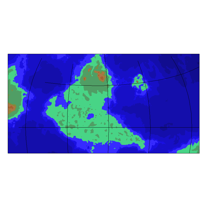
Anyhow, I've found a world that has some appealing shapes, so, following the video instructions, I exported a Altitude Moderate Detail CC3+ map. The first thing (minor issue) that I notice when opening it up is that the .fcw comes with built-in longitude and latitude lines, which I would like to eliminate (little black grid markers--to be clear, my FT3 world does not have any grids enabled.) I don't think that issue will persist, however, if I could get my next step to complete: I want to copy just one central piece of land out into a new CC3+ map so that I can trace over it and begin my editing work. Here's the issue: trying to "select" anything wants to pick everything of the same color. You can see by the attached photo that there's a central landmass visible, as well as a few islands (one larger than the other), and then two other pieces of land that are cut off. These cut off bits are present because I can't get FT3 to export a box any more precise, due to resolution. I want only the middle landmass and the island to the East, without and of the grid marks to be copied, and then this to get dropped into a new map file for tracing.
What I have tried, specifically:
Following exactly along with the video (copy-pasting the entire selection), but this results in the additional bits of land being copied over, which messes up the scale (and also lags the program refreshing hilariously badly when trying to align it, which makes it even harder to work with)
I attempted to save a "rectangular png" of just the middle island, and then import it into a new file (on a new sheet) to trace from. I'm lost with regards on how to line this up though, since there's additional white borders that get put in, and I can't see the underlying map border while trying to rescale this (using the scale tool, which is incredibly difficult to use in this sense) and trying to eyeball-line-it-up using the move tool. Not even sure if this is the way to go, I just saw a post on another forum suggest this.
I've also tried "exploding" the main selection. The problem with this is that it makes it a massive pain to select things since it either doesn't explode it enough (resulting in the same issue, where selecting any bit of land selects it all) or it makes it so full of tiny chunks (and random holes, apparently?) that I can't really select them all, so it still isn't perfect.
I do want this software to work out, but I've seen countless tales about just how user-unfriendly it is when starting out. If someone could, step-by-step, explain the exact process required to do what I'm trying to do (or otherwise tell me it is impossible and I should request a refund), that would be grand :)
Comments
Also, I just noticed after uploading that there's a lot of whitespace around the picture I uploaded. Not sure why CC3+ exports the png like that; is there a way to counter this?
Also (also), I forgot to mention: when I went through with the inserting-a-png-on-a-different-sheet technique, I noticed that the edges of the terrain became very noticeably pixelated, which is obviously not desirable. Is there a way to export in higher resolution (either from CC3+, or by going back to FT? Note that FT was set for 4096 for editing purposes, and I can zoom in rather close before things break down).
Cheers again.
The issue with everything similar getting selected is because FT3 is set to export the contours as a multipoly. This is controllable through the export settings in FT3. A multipoly is used because a regular polygon in CC3+ can't have holes, which FT3 uses for for example lakes. Things like the grid and such are also controlled by the export settings.
You can either re-export with the multipoly turned off, or use Explode from within CC3+ to disassemble the multipoly. Note that either of these will give the same result. FT3 does multipoly each contour level separately, so if you want all the contours as well, you must explode them all. This depends on what you want to do with the map afterward, but if you are going to map it using one of CC3+'s many styles, you are probably best off by just grabbing the bottom contour, which is the outline of the actual landmass. If you want to grab everything, as you experienced, a high-detail export from FT can contain many details, so to be able to select everything after exploding, use window selection, don't attempt to click on every individual entity. To start a window selection, just click somewhere NOT on the edge of an entity. And if you select too much, remember you can hold down Control when selecting to deselect stuff.
Personally, I do recommend exporting just the section you need from FT3. FT3 will export whatever is visible in the window, so just zoom into the part you wish to export. A hint here is to actually change the shape of the FT3 window itself to better fit what you want to export.
For the tracing question, both CC3+ and FT3 allows you to export at a rather high resolution. FT3 should ask you for the image size when you try to Save As -> and pick an image format, while CC3+, AFTER you have picked an image format from the dropdown you can click the options button in the save as dialog to control the export resolution. To get rid of the white space in CC3+ exports, make sure to have the Restrict to Map border and crop image to aspect ration options checked in that smae dialog.
Cheers, Monsen. I've a busy few days currently but I'll take a look at things and respond back here if I have any more questions about the same stuff.
Right, I've had time to sit down (for about four hours today) and I've achieved... nothing. By fuddling constantly with the resizing of FT3 I can get it to export a piece of the land I want (I cannot fit it all in because I'd literally have to turn my monitor sideways, so I guess I don't get to go with my original plan). Importing it into CC3 is fine, and after mucking about with exploding things to move smaller bits around where I want, I copy it into a new file.
Here's where the 'fun' begins. I followed the video guidelines from that Live Mapping video on adjusting the edges of a continent in order to have it hit the map border--it didn't work, even using identical tools (literally watching and clicking the same buttons, without using any shortcuts). Where his tool makes a clean line to the edge of the existing polygon, mine decided to make a fractal void. Alright, on to Joe Sweeney, since the LiveMapping stuff is not a particularly helpful tutorial series anyway.... and I find that his method (of blowing up the polygon into lines and drawing new ones in) not only doesn't work (because I couldn't, for some reason, ever get the terrain to fill in properly again, so I had to go back to square one) but it takes infinitely longer.
To be frank, the existing tutorial matter on this software feels so horrendously outdated that I have no will to use it; I simply don't have the time to spent ten times longer working on something to make it work in the first place, let alone look good. Hell, I have questions about the software that I cannot find the answers for, which blows my mind given this thing's age. If you have a link to a repository of helpful information and well-produced tutorials on the software, that'd be grand, but otherwise I'm giving up on it. I cannot stress how unintuitive and not-worth-it these programs feel, even when working along with videos.
One particular question/concern I should note: Assuming I stick with CC3+ and figure out a way to do my continent-scale maps in a way that I like, how neatly can I overlay a hex grid? Ideally, I would be able to use the large map's grid for hexcrawl, as large swathes of the continent are wilderness. Do default settings (with a size of, say, 6500x6500mi) allow for smaller hex grids, or does the program assume that things are going to be looked at from afar, and thus the quality is lowered when zoomed in?
Ps. I've skimmed the Ultimate Tome of Mapping; I've seen that suggested some places, and I wanted to say that it isn't quite what I had in mind when I speak of tutorials, as much of it is seems to be conceptual things related to worldbuilding, which isn't directly related to CC3+, and definitely not the area I'm experiencing this headache in.
I'm not really sure about what you want to achieve, but I can answer one tiny bit of your latest question. The quality of a grid only drops away in a bitmap app, and since neither FT nor CC are bitmap apps the grid you use is made of vector lines and doesn't look any different when rendered out at different scales.
Skimming the Tome isn't really very useful. Looking up a specific bit you want to know about is much more effective. You can use CTRL+F to find key words, or make use of the bookmarks on the left hand side in the pdf browser.
I'm sorry I can't help you more than that.
I'm not the best to help out, as I don't personally use FT very often, but regarding the Tome, have you taken a look through the Fractal Terrains 3 > Saving and Exporting > Exporting to CC3+ section?
For the regular CC3+ programs, e.g. Dungeon Designer, etc (rather than FT3, which is the only Profantasy program that stands alone from CC3+), I found an earlier version of the Tome really helpful as a tutorial. Each program has an example map that you create as you read though that section of the Tome, e.g "Basic Overland Map", "Basic Dungeon", etc. I learnt a lot from the those step-by-step "basic" maps in the original Tome and I still look in the Tome if I'm not sure how something works.
Fractal Terrains is something that I've never actually gotten into, but I've seen many maps on here by other users where they have imported from FT3 and then built onto that using a CC3+ overland style and the results are usually great, so it's probably worth persevering.
Maybe post screenshots of the options you're choosing while exporting / importing your map between FT3 and CC3+ or attach your actual FT3 and CC3+ map files here?
It's often much easier to help if the map file is available, than trying to work out what went wrong from a typed description.
When exporting an image from CC3+, I normally use the "rectangular section PNG" choice, then options and I select the image size that I want, then you select a rectangular area of your map (or the whole thing). I don't get any white edges. I convert the PNG to a JPG in GIMP, for uploading here, but there's a rectangular section JPG option as well.
Hmmm... I prefer to output a png, and import that in CC3+. I use the png as a guide, placing it on its own sheet and layer.