

ATLAS WIP: The Vale, Panaur
 jmabbott
🖼️ 39 images Mapmaker
jmabbott
🖼️ 39 images Mapmaker
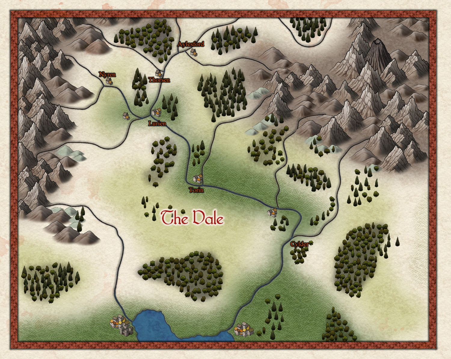
Hi Folks,
Got a little bit done on this tonight. I'll be changing the place names, apart from The Vale, for the final atlas submission to avoid any copyright issues as they're taken from an RPG adventure supplement. At the moment they're just placeholders so I can work out where I want each town.
Overall, I'm pretty happy with it for about 2.5 hours effort.
Tagged:


![[Deleted User]](https://secure.gravatar.com/avatar/c75d9a245b74d9c59be0999ea81ca541/?default=https%3A%2F%2Fvanillicon.com%2F92add7f8c954488718110edc4896ad39_200.png&rating=g&size=200)


Comments
Looks pretty good, Jim :)
Thanks folks.
@Loopysue It's the style that makes it!😉
Sue, re the terrain fills/colours, does the order they're drawn on the map make a difference to the way they blend and so on?
Thank you! :)
All the terrain colours are drawn on the same sheet and blurred into one another before they are blended to the parchment background. So the answer is kind of yes and no. Yes it matters if you suddenly cover all your mountain background with lots of green lowland grass colour, but no, because you can easily bring the mountain background polygons back to the front using the bring to front tool.
Similarly, if you wanted to put a general greenish background behind what you have already done to cover all the white (not saying you should, but just as an example), you could draw that map-wide extent and then send it to the back of that sheet.
Jim, the coastal city on the right is a very big one according to the Atlas map.
Great map and style
Thanks Quenten, glad you like it.
Re the city size, I am aware that it's meant to be a large-ish city. I'm going to end up with 2 versions of this map I think- this one, with some changes and additions for my home game which we started last night and had a blast, even though we only played for just under an hour and the 2nd for submission to the atlas.
Just to be safe, I sent the publisher of the adventure an email explaining what was going on, i.e. using Nibirum for our shared world gaming and asking if I could use the place names from the adventure on the atlas map. As expected, they were quite fine for me to use the names for home use but not for general distribution, so the atlas version will have some minor changes; the names for a start and be a little more settled, where for simplicities sake, the home game will keep the place names and be less settled. I'll just move stuff that needs to changed to different sheets & layers until I'm finished and then save an atlas version with home game stuff deleted.
Hi All,
I think this is done. What do you folk think?
I've saved another version with the original, adventure names.
Great work, Jim :)
You will have to do a town or city on this map in Sue's upcoming Darkland City style. Great map
Thanks @Loopysue, @Quenten,
Well next up are the villages of Ravenhame (Thorsen) and Abbotsford (Ayleford). Unfortunately, I'm going to need those two for my home game before the style comes out, I'll probably use existing maps for them, but for the atlas, sure.
I think this needs a road heading east and another heading north into the mountains where the mine is (note to self: swap out a mountain symbol for the one with the hole in it!) from Smallport and of course, I'll also need to add a mining town!
Speaking of doing a town/city in this style, I've done the regional map for my latest commission in the Darkland's style and now I'm working on the city.
The city is approx 3600m x 2880m, a third of it is on a cliff top. I've 'imported' the Cliff Annual tools but the cliff and cliff top look pretty average at this scale (I changed the symbol size to 1.0), I don't think its going to work and will try the styles included symbols. Is there a 'recommended' maximum size for the Darklands City style?
The map will be published at US Letter size - I know that's not important for CC3+, you can export at any size, but the map still needs to be 'readable' at that size.