

A couple maps
 Autumn Getty
🖼️ 18 images Surveyor
Autumn Getty
🖼️ 18 images Surveyor
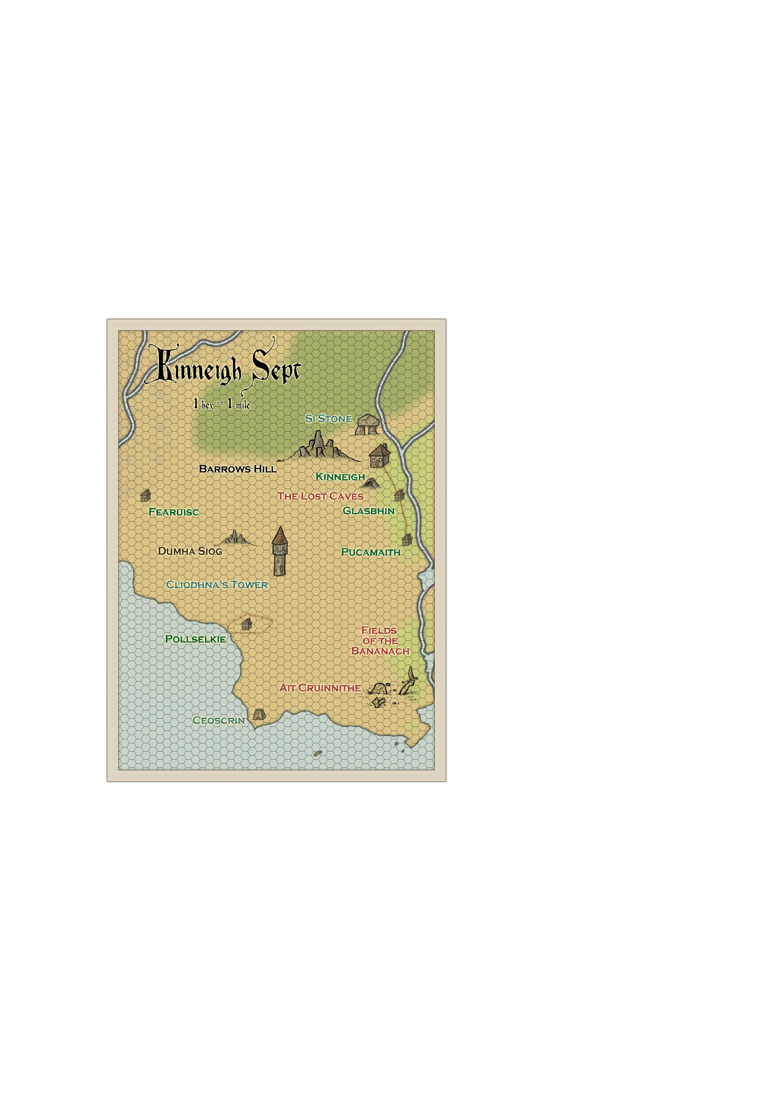
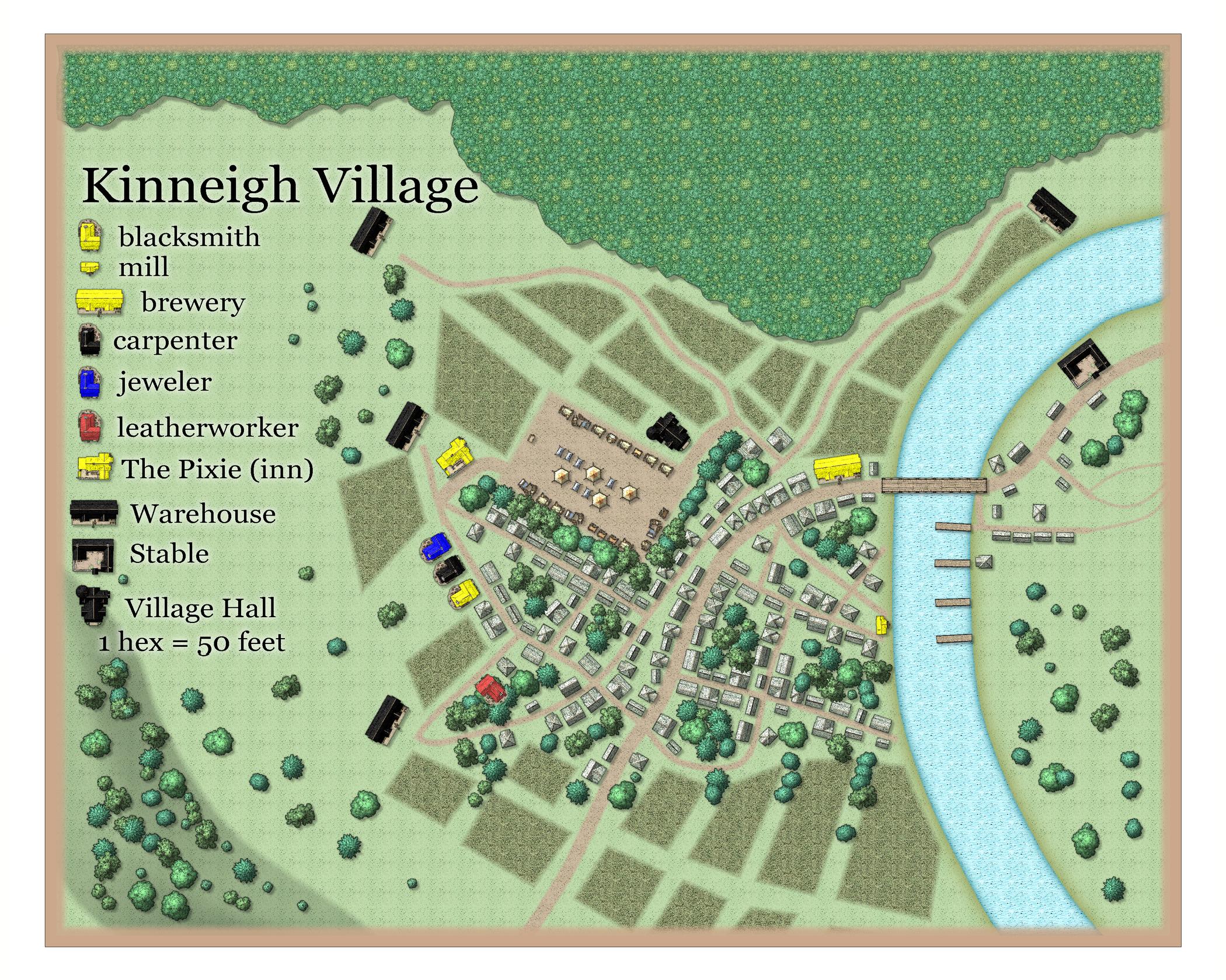
I wanted to share a couple maps I've done recently to see what people think of them. These are two maps in my campaign world, one a local area map and the other a village map.
![[Deleted User]](https://secure.gravatar.com/avatar/c75d9a245b74d9c59be0999ea81ca541/?default=https%3A%2F%2Fvanillicon.com%2F92add7f8c954488718110edc4896ad39_200.png&rating=g&size=200)


Comments
Great maps, Autumn :)
I'm curious to know why you leave so much white space around the edges. Is that deliberate, or something that just seems to happen?
It's not deliberate. It's because I've been playing around with export sizes to figure out the best printing vs. web display (like on virtual table tops). It hasn't worked out the way I thought it was supposed to. So confused lol.
Thank you for the compliment. I feel that the text is too large on the first one.
Well... maybe, on the font size.
It's bit hard to tell when the map is so small in all that white.
If you want to get rid of it and get the maximum map for the minimum MB, try using the "JPEG Bitmap file" save as type, and making your settings a bit like this:
The area of the map is then automatically rendered within the map border, and trimmed on the short side so that the long side is 3000 px.
Hey Sue thanks for that. I have been using jpgs. I looked up a few sites on the internet and pixel sizes for different page sizes and they don't seem to be accurate for CC3+. I played around with a few different sizes and last night tried 3000 as you suggest here, and it definitely fills the page. I'm glad you've mentioned that so I can keep it as my baseline from here on in, rather than further experimentation.
You're welcome :)
Its a personal standard export setup that I've gravitated towards over the years.
@Autumn Getty wrote:
I looked up a few sites on the internet and pixel sizes for different page sizes and they don't seem to be accurate for CC3+. I played around with a few different sizes and last night tried 3000 as you suggest here, and it definitely fills the page.
Note that this doesn't have anything to do with the pixel size (or file format), it is the Crop Image to aspect ratio and Restrict image to map border combination that ensures that the exported image only contains your map, and not white area outside it.
What Remy says is very true.
The setup I showed you works for most maps (and as long as you haven't either deleted or hidden the MAP BORDER layer). The case where it really doesn't work is if your map is square, or less rectangular than is normal for the average map. Then you will have to reduce the px sizes in the top two boxes to fit the width of a standard piece of paper rather than the length of it.
Thanks to you both for this information. I did notice at one point that the crop image and restrict boxes became unchecked somehow, even though I always use them. I actually had a few different problems in terms of my usual settings changing after closing one day. I wonder if something's happened to the program.
The area map looks pleasing in overall style, though I'd suggest a different scaling. Some of the symbols are far too huge to tell where they're meant to be, given the hexes are a mile across each. It might be worth considering shifting to the classic "Old School" style hex maps, with a single terrain feature or item per hex of whatever size, perhaps, if you want to retain the hexed look. If retaining this current hex-size and then re-scaling though, most settlements will end up looking like dots. And should "The Lost Caves" even be shown on the map? They are "Lost", after all. ?
The village map doesn't appear to have any hexes (the scale comment). The Inn seems oddly peripheral to the entire settlement, and a very long and extremely circuitous way from the Brewery. Similar problem with the Blacksmith and the Stables; they needn't be neighbours, but likely a bit closer than this. The Blacksmith also needs a reliable, easily-accessible water-source (well, say, or a spring). Assuming the Mill is a water mill, it would benefit from having its own small, controllable water channel off the main river (= a leat). Lot of oddly large "Warehouses" well away from anywhere whatever's stored there might be used/needed, unless they're not so innocent as the name might suggest...
So my computer's hard drive failed last week and I may have to redo these. I ended up buying a new computer, which I'm hoping will last for a while.
@Wyvern Some really great comments here. I did actually change the scaling on the area map, as it was really bothering me as well. I'll post it at the end of the comment. Your notes about the village are very good ones. I guess I was thinking I wanted the inn and the craftsman near the trading area, as it made sense to me that these would be services that would be used by traveling merchants and farmers. It seemed odd to have the brewery too far from the river, but I think at this point your probably right. The problem is probably in the placement of the market area. As for the warehouses, I meant them really to hold grain from the farms surrounding the village. Thanks so much for your in depth comments.
Oh, also... "The Lost Caves" are the location of a system of caves that appear in an adventure I wrote. Since the area map is meant to form a map for that adventure and a few others, I included it, but definitely a GM's map.
I think the hex-size and location-scaling issues stand out so much for me because my experiences with hex maps began with the SPI board wargames, where hex-placement of symbols and units was absolutely key, and that translated into the earliest RPG hex maps I worked with, those by Judges Guilds, where again the settlements were scaled into the hexes, with things like isolated strongholds and towers reduced to very simple, tiny, open squares and circles, so small it was often hard to find them quickly, which is perhaps pushing too far towards the other extreme!
For the village places that need to be in better communication, it would be possible to have them stay where they are, but introduce much more direct routes between them. This might mean redesigning other parts of the village to fit - reasonable, because the village would have grown up around such existing routes. If the houses had been there first, the important places would have been sited differently, to allow those more direct routes to be possible from the outset.
There's a fair chance the marketplace would have ended up more central too, as in reality, such things often started out on the Village Green, an open area in the middle of the village to allow community events originally. It could be moved to somewhere more peripheral if it needed additional space the Green area couldn't provide. The Inn would likely end up by the Green too, again as a handy near-central location. If the market moved, the Inn might have its effective facing altered, or simply expand (if space allowed) to provide patron access from all the suitable directions.
On the hexes, I have the same inclination (making the symbol the size of the hex). I guess I feel like the hexes here are much too small for that, though I looked at the first Dragonlance module (if you're familiar with that) and the symbols there were actually quite small as well. I feel like that module really did an excellent job on things like wilderness maps, keyed events and stuff. So maybe I should just do the symbols at that size.
I have to say I do think you're absolutely right about the village, and that I already knew some of this, but I think I was sidetracked by wanting to stick to a village map I generated on Watabou's site. After downloading CC3+ onto the new computer, I discovered that a Celtic buildings add-on was created, and I had wanted all along for round turf-house style buildings as the region is meant to be based on roughly 6th century b.c.e. Celtic villages, which were quite simple. All that to say that I might just revisit it and use a lot of your ideas here in addition to more Celtic buildings.
So thanks :).
You're welcome, Autumn!
The D&D Dragonlance setting came along (circa 1982, according to Wikipedia; I had to look it up!) shortly after I'd moved away from the published D&D rules to my own, what we'd now call "homebrew", variant, so I missed it. Checking around online, it looks as if the first module was DL1 "Dragons of Despair" from 1984, and digging around a bit, I found some images of the hex map in that, where the places are indicated by simple geometric icons, only a bit more sophisticated than simple dots, as far as I could tell. That makes sense for hexes of this size, certainly.
I think it depends really how you want to use the hexes on the map as to which way to go from here with them. They're very good for quickly measuring distance, if in a somewhat approximate, slightly stylised, way. If that's a priority, it would be better to fit things like roads and rivers to match that hex grid, so you can work out how far X is from Y using this or that transport route. It might be useful too to have natural linear features, such as forest limits, coastlines and mountain-peak ridgelines, fitted to the hex grid as well, so it's clear exactly where such features are. This seems to be what that Dragonlance module map shows, as far as I can tell.
If you'd prefer the grid to be more decorative, and make more use of pictorial symbols, perhaps closer to the manner of having one terrain symbol per hex (so where the terrain patterns become entirely hex-based, but where you can still include settlement symbols on top of the terrain in a hex, if any), larger hexes would be needed than those shown here.
The fact your hex map features pictorial symbols and features which largely ignore the hex grid entirely does make me wonder what purpose the grid is really serving for you right now, other than as a decorative overlay. If so, how committed are you to retaining it?!
I am a fan of randomly-generated maps or features, so I understand your desire to use the Watabou village you were happy with as-is. However, "random" does sometimes throw out things that may need tweaking a little too.