

WIP: Cartographer Guild May Challenge
 jmabbott
🖼️ 39 images Mapmaker
jmabbott
🖼️ 39 images Mapmaker
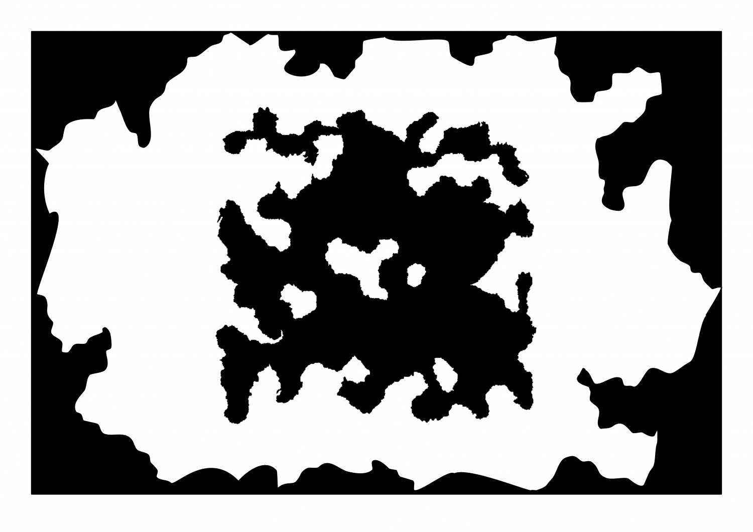
Howdy folks!
Another little project I'm working on, though this one has a deadline - 14th May.
Over at the CG they have a monthly (some-times bi-monthly) lite challenge. This months is to map a shape. The shape is a square with a generated image. The only thing is you have to map the shape as a landmass, not sure if it's allowed or not but I'm going to invert the shape and use it as the inner sea where the negative space will be my landmass. I'm going to use @Loopysue's Darklands style just for the hell of it.
I've currently imported the shape into Affinity Designer (A2 Landscape) and created the 'outer sea'. I've saved this as an SVG file which I'll convert to DXF and select by colour and use the change like draw tool command to create my seas (if it works). Here's a jpeg.
![[Deleted User]](https://secure.gravatar.com/avatar/c75d9a245b74d9c59be0999ea81ca541/?default=https%3A%2F%2Fvanillicon.com%2F92add7f8c954488718110edc4896ad39_200.png&rating=g&size=200)
Comments
Something like that I believe...
Alternatively, you could knock out the white in GIMP and import and trace the black in CC3?
I hope the Darklands works well for you. It is designed to make PS-style land shading easy in CC3 - and no tracing required. If you have any issues you know where I am ;)
Well, doing the whole SVG-DXF thing was a disaster, so I just imported a JPEG version and traced it.
Here's an update:
Looks like you are off to a good start :)
Hi Folks,
A bit more work this afternoon. Starting to look more like a map than a psychiatrists tool now...
Nice work on the rivers so far :)
The way the terrain textures are designed, it may be easier to add the rest of the various greens and browns before the mountain background, though it depends on your personal taste. All of them (the colours - including the mountain background) are just polygons drawn on the same sheet and massively blurred, then blended with the paper, so whatever you add first tends to diminish beneath later colours that overlap. If this happens to your map just use the bring to front tool and grab the mountain background colours (there are 3 of them in fact in various shades of increasingly dark grey) to bring them forward.
You may find that doubling or trebling the size of the blur on the TERRAIN Colour sheet will improve the overall appearance of the map, since it is quite a large map. The colours are meant to work like a smooth gradient across the map without any noticeable edges. Edges are for the scrub and farmland textures, which are on different sheets to the terrain colour.
The colour palette with this style contains all the terrain colours in a single row. Towards the right hand end of that row of colours there are a range of colours for the varicolour hills so that you can match them with the terrain colours a little better when you have finished colouring the terrain. You can change the colour of a varicolour hill using the change properties tool if you end up with any mismatches by the end.
Hi @DaltonSpence I hadn't considered that the inner sea may be at a higher elevation than the outer sea, it's a very interesting thought. At this scale I don't know how 'visible' such features would be... I don't think I'll have time to work that out as the competition closes Thursday. I was hoping to spend some time yesterday on it but what with Mothers Day and all i just didn't get the chance.
BTW: Happy belated Mothers Day to all the mums out there!
I've been giving this some thought and I'm going to base the topography/climate on mainland Australia, doing a horizontal flip if you will, so the east cost on my map will be mostly arid, barren and the west coast, temperate and lush on the outer sea side and drier on the inner sea side.
Hi All,
Here is an update. I narrowed the rivers a little, 7 miles wide seemed a bit too much...added some terrain colouring and the jungle in the tropical portion as well as some settlements here and there.
Looking good :)
I think you may have used a bit too much compression on this JPG. I'm getting those nasty little squiggles. 90% is enough. Never ever sacrifice quality for having a file size that is unnecessarily tiny.
BTW, Happy Mother Ocean's Day!
A further update. Water contours, labelling, a few minor tweaks (thanks @Loopysue ) and this all but done, well as done as it's going to get for the challenge.
That's a really small image, so it's quite difficult to tell, but it looks good :)
I would recommend adding place names if you can, since the lack of them makes it look a bit unfinished
Yeah, sorry about that. I thought I'd posted last night, and obviously didn't so I grabbed the image from the FB post but only got the preview image - I'm not very good with social media...
@Loopysue Yes it will get some place names...
For those of you into RPGs, which I believe is a high % of this audience?, the northern jungle is home to 'primitive', cannablistic halflings; the southern wasteland is the home of orcs, the east and west coasts are settled by humans, while the mountains of the east are the realms of the dwarves. The tower in the crater belonged to the sorcerer who, according to legend, was responsible for the breaking of the continent...
Ok Folks, this is as good as it's getting for the challenge. Undoubtedly there are numerous tweaks that could be made but I've simply run out of time. Feel free to use however you wish except commercially.
Very well done, and in such a limited time :)
Thanks Sue. As I posted on the FB group, and as @Shessar said, the combination of CC3+ and its artwork make it a heck of a lot easier for us to produce maps without having to worry about also being 'artistic'. This style is great and you and all the other artists, as well as the CC3+ development team are to be commended on providing such a great tool.
Hi Folks,
Voting is now open for this challenge. If you’re a member of the Cartographers Guild, hop on over and check it out.
Well, I didn't win but I did get 4 votes! Given the quality of the entries that is not a bad result!
You'll get there eventually. The trick is to stop caring about whether you win or not and just have fun ;)
Hi @Loopysue and @Monsen
Not sure this is the right place to post it. I was trying to "edit text" in "darklands" style using the beta version of CC3+.
The command did not open the common window but enlarged a copy of the text.
When refreshing it disappears but the text can not be changed. It happens only on the specific "map text": Title, scalebar, and copyright.
The text added as simple text can be changed.
I have trouble with this as well. In the end I tend to lose patience and delete it, then just put the title in as ordinary text on the right sheet and in the right colour.
However, I would also like to know how to use it properly.
Is this just in the Darklands style or does it happen on other maps?
I don't want to hijack this thread too much, Joe, but I've had this issue every time I've used one. Its more an issue of not knowing how to steer it, I think - at least in my case.
It seems it happens with other maps, too...
According to Ralf, it's using TED on text attributes associated with a symbol (like the map title). Some investigation shows that the attribute is incorrectly displayed at 0,0 as part of canceling the command internally and the spurious display will correct itself at the next redraw. Getting rid of the accidentally-displayed text is on the wish list to be fixed.