

Map Construction
 mike robel
🖼️ 15 images Surveyor
mike robel
🖼️ 15 images Surveyor
As you all may recall, I frequently construct my maps by the size I want the printed out sheet to be (say 11 x 17 inches) versus the actual size of the map (say 11 x 17 miles). This is because I find that when I use the size, the map is not normally displayed the way I want it to be. (For example, I frequently want the map printed edge to edge and be 22 x 34 inches wide and be composed of 4 each 11 x 17 inch sheets of paper. For the moment, never mind that I usually have to print them out on 12 x 18 inch sheets and have the printer cut them because they cannot seem to print edge to edge.)
I also almost exclusively use SS3 Modern Political regardless of the scale but I like the symbol set from SS3 Pro.
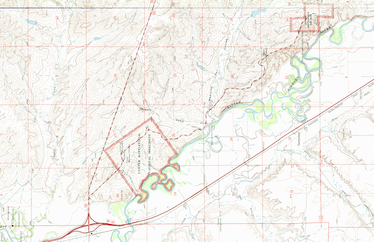
You may also recall I am very fixated on the Little Big Horn battle. I wanted to model the terrain with a specific size to incorporate certain terrain features and I want to have the map be 11 x 17 inches when printed. I digitally combine two map sheets and then crop it to the terrain I wish to model, rotate it 90 degrees to the left and save it as shown so the map fits nicely on my screen. The map is 1:24000 scale, thus 1km = 4.2cm. (I know it is confusing to mix the two UOMs here.)
Next I make a new map project using SS3 Modern Political and specify the size as 17 x 11, add the BMP sheet, save the map, Insert File, and LO! The map fills the rectangle nicely. Yay.
Now I start a new map using SS3 Pro, input the map size and notice the difference. Two things. (1) the map is clearly not the size I want it, although the total display size seems to be correct, and (2) I do not want the legend to be displayed.
The FCWs are attached. While I am perfectly happy associating the SS3 Pro style with the SS3 Modern Political, I would like to just be able to use the SS3 Pro because it just feels better to me.
I guess what I need to do is make the map size about 20.89 by 11? (The total distance for the map seems to be 17 inches, while the map itself is about 13.62 inches, so the map width = 17+(17-13.62) and I can get rid of the map border by hiding the Map Border Sheet. However, that did not seem to work either.
Is there a better way?
Just to confuse matters, when I print the map, it will be 32 inches x 22 inches and printed on 4 12 x 18 sheets of paper which I will then trim and assemble. A cavalry troop of the time would usually occupy a dismounted space of about 260 meters. (1 out of 4 troopers are holding the horses and the officers and non-commissioned officers are behind the firing line and there may be a small reserve, so were I to put a hex grid on the map, then I would make them be 250 meters (Each square below is 1km).
Thanks as always for any advice.
P.S. I have some other issues if I try to size the map in kilometers rather than inches, but I am trying to figure that out.
Comments
Most printers have what is called a "bleed area" where the printer physically is unable to print. Is that what you are referring to when saying it can't print edge-to-edge?
When using the print dialog from Campaign Cartographer there is a "Scaling" section in the options.
This will figure the math out for you. The paper distance is how far across the page (in inches). The Drawing distance is how many map units should correspond to the paper distance.
In battlemaps for example, it would be common to say something like 1 inch of paper distance should be 5 feet of map units to get 1" grid squares on paper (assuming grid is on 5 unit width)
Because your map is set up for 17 units x 11 units, it would seem you have set it up for each square unit to be 1 inch square on paper, so your Paper to Drawing distance is 1.0 to 1.0
Unfortunately, I cannot open your FCW files at the moment, and I'm struggling to understand the change of map size you are experiencing on the second style of map. As long as the map takes up the full 17 x 11 map unit area and your scale is set as 1.0 to 1.0, the outcome should be the same.
If somehow the total unit distance has changed to 13.62, you could put 17.0 as the Paper Distance and 13.62 as the Drawing distance and it would work out the stretching conversion for you.
I believe the legend can be hidden using your sheets, or it could be erased completely with the eraser command. If you are unable to select it, it may be on a frozen layer.
I have an Epson printer which will print edge to edge and an HP which does it based on the type and size of paper and this works fine for me for my prototyping runs. When I send the map to the printer, their printers apparently don't do edge to edge printing, so I print out the map from CC3 using the Print Function and tell the program to print out an 11 x 17 image which it does as a PDF. Then I save CutePDF images as a JPG, place them into PowerPoint on a 12 x 18 inch sheet with crop marks, save the file as a pdf, and send it to the printer. They print it out, crop it, and fold it for me. It sounds convoluted, but works fine.
The actual distance covered by this map in 1:24000 scale is about 6.4 km wide by 4.2 km tall. sometimes they are much larger and sometimes the map covers an area about 1100m x 1700m with 1km hexes. It varies by map size.
When I input actual distances in, as the instructions tell you to, I am not able to size my printed maps correctly to fit my requirements which is why I size the map to print out in the desired size for printing.
When I set up with SS3 Modern Political like so I get a map that is 17 x 11 inches in the first picture below.
After inserting the file I end up with the map properly configured and filling the image.
Now to set up SS3 Pro with a map to be 17 x 11. As you can see here in the 1st photo, I have typed in 17 and 11.
In the next shot, the map image has been inserted, but it is 17.58 inches left to right and has set itself to 13.35 inches to to bottom. The map dimensions are, however about 17 x 11, but I have this blue area up on top.
Sometimes, if I push next before finishing, then go back, and then push the next button again, the dimensions set themselves to 13 x 11.
In so far as the grid, I use a hex grid. In this case, I want to have the 1km grid from the map to have 4 hexes inside it, so each one is 250m wide, as shown below. The sizing is arrived at by experimentation and the size is 0.65. The grid is actually a trapazoid and not a square/rectangle, but it is close enough for my work.
Sorry if this seems pedantic over what might just be a typo. In your first image for SS3 Pro the dimensions in the screenshot actually say 17 and 13 rather than 17 and 11. Did you happen to take the screenshot before it was changed to 11 or is the two extra units why you have extra blue space?
Note that the SS3 Pro template require proportional scaling. This is set up this way due to the legend at the right, it would look weird indeed if it was scaled arbitrarily. So the new drawing wizard enforces a 5:4 ratio on that template. So 17 by 11 is not a valid size for this particular template.
You'll notice how the width and height change in relation to each other if you just exit that particular input field instead of directly clicking the next button. Change one, and once you exit the field, you'll see the other update to the appropriate value for the constrained ratio.
Actually, I failed teo notice that while working on the post. I noticed that sometimes the number would sometimes set itself to some other number if I used the Next/Back buttons to troublesshoot. The map portion appears to want to be a square. I find it frustrating to say the least.
@Monsen Yes. I guess that is what I was describing above. At any rate, it makes the map pretty useless for my purposes, so it is back to SS3 Modern Political rather than the other ones. I like the map legend though,
Templates have different advantages and disadvantages. Generally, all maps with particularily "fancy" elements have constrained dimensions because the new map wizard doesn't have the facilities to just scale the map area (technically, CC3+ doesn't have a separate understanding of the intended mapping area and outside elements like this, everything is just "the map"). So for these kinds of maps, free scaling is impossible. You can always edit the mapping area after creating the map though. Everything is still just regular entites, you can manipulate it as you wish, you just have to do some manual work, since it won't be 100% ready straight out of the new map wizard.
I would personally layout the map on the 18x12. I would bring the crop marks into CC3, and then when I go to export the PDF for home use I would export a rectangular selection that is only the 17x11 area and when needed for the printers I could do a full export which would include the bleed area and crop marks. This would cut out having to mess with many tools outside of CC3.
What you have works though, I would never blame somebody for not breaking what already works.