

Changing Properties and Importing SRTM Contour Lines from FT3
 choppinlt
Traveler
choppinlt
Traveler
Hello, I am a new user to both CC3 and FT3. So far I have really enjoyed using CC3, but I have been having issues with an apparent lack of changing properties. So clearly I am having some noob issues.
I am tracing over a 1:1,000,000 hand scanned topo map. Generally things go well, but I run in to some real head scratchers. There are 2 issues I am currently trying to figure out. First, I am using the polygon tool to trace over urban areas. After a save and coming back to it the next day, new polygon's won't completely fill. They appear only as a tracing line. Second, I hand drew a contour with the smooth poly tool. After I complete it, it looks good, but immediately disappears upon redraw. I can only find it by hiding the topo template sheet, and even then it is a different color that won't change. In fact it doesn't appear to allow me to edit properties at all. FYI the topo template is "below" the contour sheet, so that should not be the reason.
Speaking of contours I just bought FT3 to see if I could replicate what I have seen others do with contour lines. I downloaded .hgt files that I wanted, and I imported them in to FT3 per WeathermanSweden's post. I found the area I wanted and Saved to a CC3 map. When I open the file in CC3 I see the outline of the area as a solid green fill...i.e. no contour lines. I have fiddled with some of the options, but to no avail. Being perfectly honest here I have NO IDEA what options to even consider messing with in the first place.
Any sugguestions, thoughts or solutions to the above? THANK YOU in advance.
Best Answers
-
 mike robel
🖼️ 15 images Surveyor
mike robel
🖼️ 15 images Surveyor
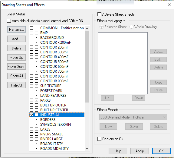
Polygon fill: Make sure you have the line width set to 0.00000 or it does not fill in. I trace urban areas as you describe, but I put them on their own sheet. In fact, I may have 3 sheets. Urban Center, Suburbs, and outskirts. Sometimes an Industrial one as well. Generally, I start from the outside in, with the outside sheet being on the bottom and the Urban Center on the top. You can see it below: Gray: Industrial, Black: Center, Red: Outskirts

-
Loopysue
ProFantasy 🖼️ 41 images Cartographer
Ok. With only that one sheet visible use the Change Properties tool
 to set their fill to hollow, and the outline to black. That will help you to see them properly. Then you will be able to do what you wanted to do with them, whether that is to set them up with different colour fills or just use them as contour lines.
Answers
Polygon fill: Make sure you have the line width set to 0.00000 or it does not fill in. I trace urban areas as you describe, but I put them on their own sheet. In fact, I may have 3 sheets. Urban Center, Suburbs, and outskirts. Sometimes an Industrial one as well. Generally, I start from the outside in, with the outside sheet being on the bottom and the Urban Center on the top. You can see it below: Gray: Industrial, Black: Center, Red: Outskirts
Polygon Fill line 0.0- BINGO, that was it, thank you Mike! Any ideas on the contour line issue? I'm sure it's my own ignorance here too, but I have spent a lot of time trying to figure it out to no avail.
Lastly, anyone have a solution to my issues with the importing of contour lines?
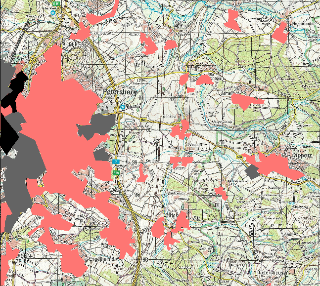
Contours that are the same colour but laid on top of one another in a big pile of contours can look like just one entity. Find out just how many you really have there by using List in the Info menu and box selecting all you can see.
I give each contour it's own sheet and a unique color.
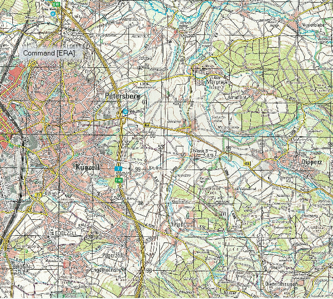
Thanks Loopy, I'm not sure exactly what I am looking at...but here is a picture of what I think the answer is...
When you scroll down that list how many separate 2D Multipoly entities do you have? Each one of them will be a different contour line, if you have more than one. If you don't, then we need to go back to the export settings in FT3 and see why you aren't getting the contours.
Hmmm, there appears to only be 1! OK, so what do I need to do in FT3?
Sorry upon further view I see several... I believe it is around 20 of the 2D Multipoly Relief/Contours
Ok. With only that one sheet visible use the Change Properties tool to set their fill to hollow, and the outline to black. That will help you to see them properly. Then you will be able to do what you wanted to do with them, whether that is to set them up with different colour fills or just use them as contour lines.
OMG Loopysue, thank you SO MUCH! ?That worked like a charm....I knew I was doing something wrong, but just not familiar enough with everything. And Mike thank you so much too! Both of you have been a great help. FYI, I figured out my own issue with the disappearing contour. It had to do with a sheet setting for the contours. Thanks again all!
You're welcome :)
Help here on the forum is great. I still have stuff to learn.