

Issue with outlines after copy/pasting landmasses into larger map size
 wkscrombie
Newcomer
wkscrombie
Newcomer
Hi! I'm entirely new to CC3+, but after watching Joe Sweeney's and Josh Plunkett's excellent tutorials, I figured I knew enough to get started. Once I'd drawn out most of my landmass, I realized that the map size I'd started with was too small for what I was going for, so I copy/pasted my landmasses from the original 1000x800 to a 1618x1000 area. However, all new landmasses I draw have a significantly thicker border than those I copy/pasted in, and I can't figure out how to make them the same. Any tips? Thanks in advance!
Best Answers
-
 Loopysue
ProFantasy 🖼️ 41 images Cartographer
Loopysue
ProFantasy 🖼️ 41 images Cartographer
You could go back to the original and use File->Resize Drawing Area to make that one the size you really want it to be.
Or if you've done too much work in your new map to want to go back to it...
In the Draw menu there is a Draw Like command. You can use this to pick up the properties of any polygon entity in the drawing and be ready to draw with those properties.
Alternatively, having picked up the properties from the more desirable landmass you can then use Change Properties to change the properties of the others. The defaults offered to you in the Change Properties dialog will at that point be the ones you need to make them match.
Be careful, though. Some landmass drawing tools draw polygons on different sheets, like the Mike Schley style for one. In that case you should hide all but the LAND sheet, or all but the COASTLINE sheet, and work on them separately.
-
Loopysue
ProFantasy 🖼️ 41 images Cartographer
If you use the Draw Like tool in the Draw menu you can pick up the exact width of the line on the entity you prefer, and then modify the drawing tool. Here I have done this with the coastline, which is the only part of the entity that has a line width to be other than zero (the land automatically has to have a line width of zero to be filled). Then I have opened the drawing tool dialog and clicked Advanced. I've picked the Land, Default drawing tool, which draws both land and coastline, and then edited the Outline, which is the coastline entity of the two things this tool draws.
The properties of this Outline show how it is a "Fraction of the Map Border".
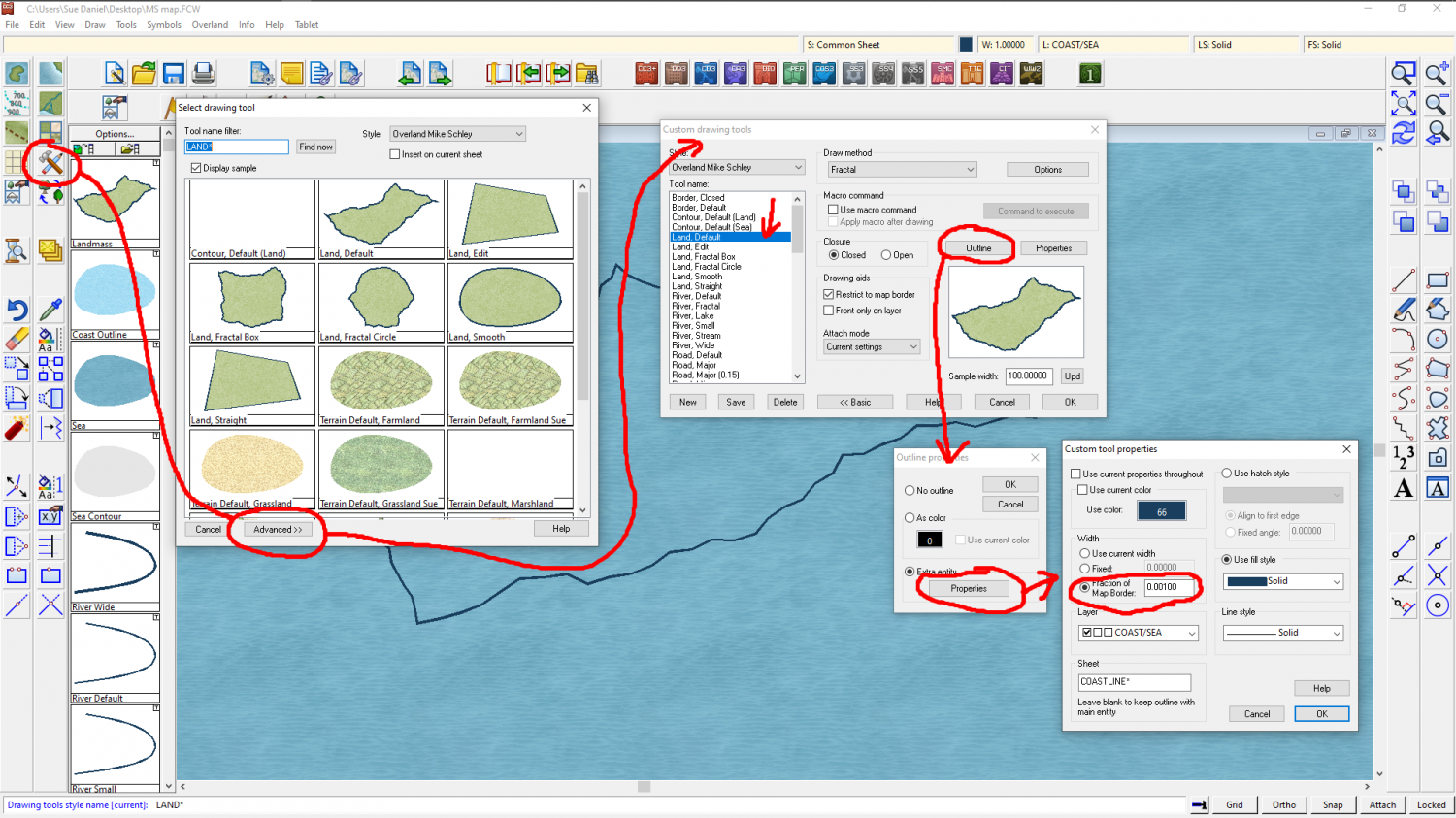
All I have to do to fix it at a certain width is to pick the option above that one. I set it to fixed and to the value of 1, which is the line width I previously picked up from the Draw Like command.
You don't need to save this change, but use the tool immediately.
If you want to save the tool it is better to go back two steps to the advanced dialog and click the new button - to make your own copy of it. This is because you are playing with the drawing tools that are part of the template, and any changes you save into the originals will be there until such a time as you change them again, or reinstall the software.
Answers
You could go back to the original and use File->Resize Drawing Area to make that one the size you really want it to be.
Or if you've done too much work in your new map to want to go back to it...
In the Draw menu there is a Draw Like command. You can use this to pick up the properties of any polygon entity in the drawing and be ready to draw with those properties.
Alternatively, having picked up the properties from the more desirable landmass you can then use Change Properties to change the properties of the others. The defaults offered to you in the Change Properties dialog will at that point be the ones you need to make them match.
Be careful, though. Some landmass drawing tools draw polygons on different sheets, like the Mike Schley style for one. In that case you should hide all but the LAND sheet, or all but the COASTLINE sheet, and work on them separately.
Fantastic, thanks for the quick response! I had no idea that resizing the drawing area was an option; that was perfect. Now that I've done that, though, I have a follow-up question: is it possible for me to select all the landmasses and drag them to a different part on the map? When it resized, they all ended up in the bottom left, which wasn't quite where I was planning.
And oops, sorry, I may have spoken a little too soon. The updated map dimensions draw new landmasses with the same border thickness as the second, larger map I'd originally created, and when I tried using the Draw Like tool to select the original landmasses, the new ones I drew with it didn't have any border at all. Sorry for my general noobishness here, but is there a way to manually set all landmasses' outlines to have the same thickness?
Yes.
Just make sure you hide all the other sheets first so you don't move anything you didn't want to move. Then pick the Move,Scale,Rotate tool, and select all the bits that you want to move and press D on your keyboard for do it.
Watch the command line. It will ask you for an origin point to start the move from. You need to click somewhere first to give it a 'move from point'. That gets a lot of people ;) While you are in the process of moving things the command line gives you useful hints about keyboard controls that will allow you to simultaneously rotate and scale the things you are moving. If you don't want to do any of that just keep your other hand off the keyboard. I've lost count of the number of times I've accidentally scaled and/or rotated something while moving it.
All good to know, thanks a million! Any thoughts on the border thickness issue?
You're welcome :)
I can't say what caused that for certain, but on some overland templates some drawing tools line widths are controlled as a percentage of the width of the map. This is the first thing that would seem to be the likely cause.
Ahh, gotcha. I'll play around with it and see if I can find a solution. I appreciate all the help!
If you use the Draw Like tool in the Draw menu you can pick up the exact width of the line on the entity you prefer, and then modify the drawing tool. Here I have done this with the coastline, which is the only part of the entity that has a line width to be other than zero (the land automatically has to have a line width of zero to be filled). Then I have opened the drawing tool dialog and clicked Advanced. I've picked the Land, Default drawing tool, which draws both land and coastline, and then edited the Outline, which is the coastline entity of the two things this tool draws.
The properties of this Outline show how it is a "Fraction of the Map Border".
All I have to do to fix it at a certain width is to pick the option above that one. I set it to fixed and to the value of 1, which is the line width I previously picked up from the Draw Like command.
You don't need to save this change, but use the tool immediately.
If you want to save the tool it is better to go back two steps to the advanced dialog and click the new button - to make your own copy of it. This is because you are playing with the drawing tools that are part of the template, and any changes you save into the originals will be there until such a time as you change them again, or reinstall the software.
Here is a drawing tool I made for myself that uses all the current properties - layer, sheet, colour, fill, line width etc. It's just handy for the way I work, which is different for everyone. As you can see from the preview it's shown just like the coastline - the properties of which I picked with the Draw Like command.
This one isn't suitable for what you want to do because it only draws one polygon. I just wanted to show you that if you make a new tool and save it, that new tool will show up every time you use that template to make a new map in that style. It's a bit blurry for some reason, but the tool is called Sue, default. Only I have this tool because it is one I made for myself.
Whoa! That's a superb explanation. Thank you so much! This will make my cartography so much easier :)
You're welcome :)