

World of Myirandios - Regional Maps - 1600 x 1600 km
![[Deleted User]](https://secure.gravatar.com/avatar/c75d9a245b74d9c59be0999ea81ca541/?default=https%3A%2F%2Fvanillicon.com%2F92add7f8c954488718110edc4896ad39_200.png&rating=g&size=200)
Here is where my 1600 x 1600 km (ie 1000 x 1000 miles) maps will be of my world of Myirandios.
I am not sure how I will do the polar regions yet; obviously not as the square grid in this equi-rectangular map. Suggestions welcomed, and especially value Wyvern's comments on the worldbuilding aspects.
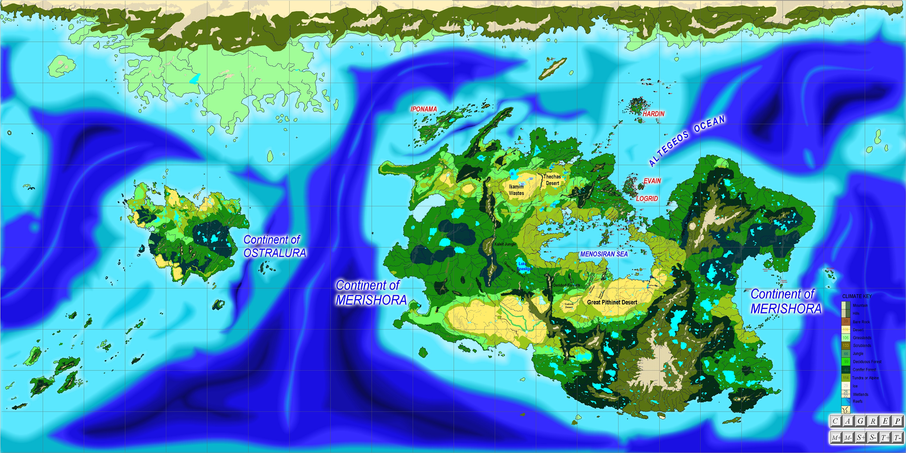
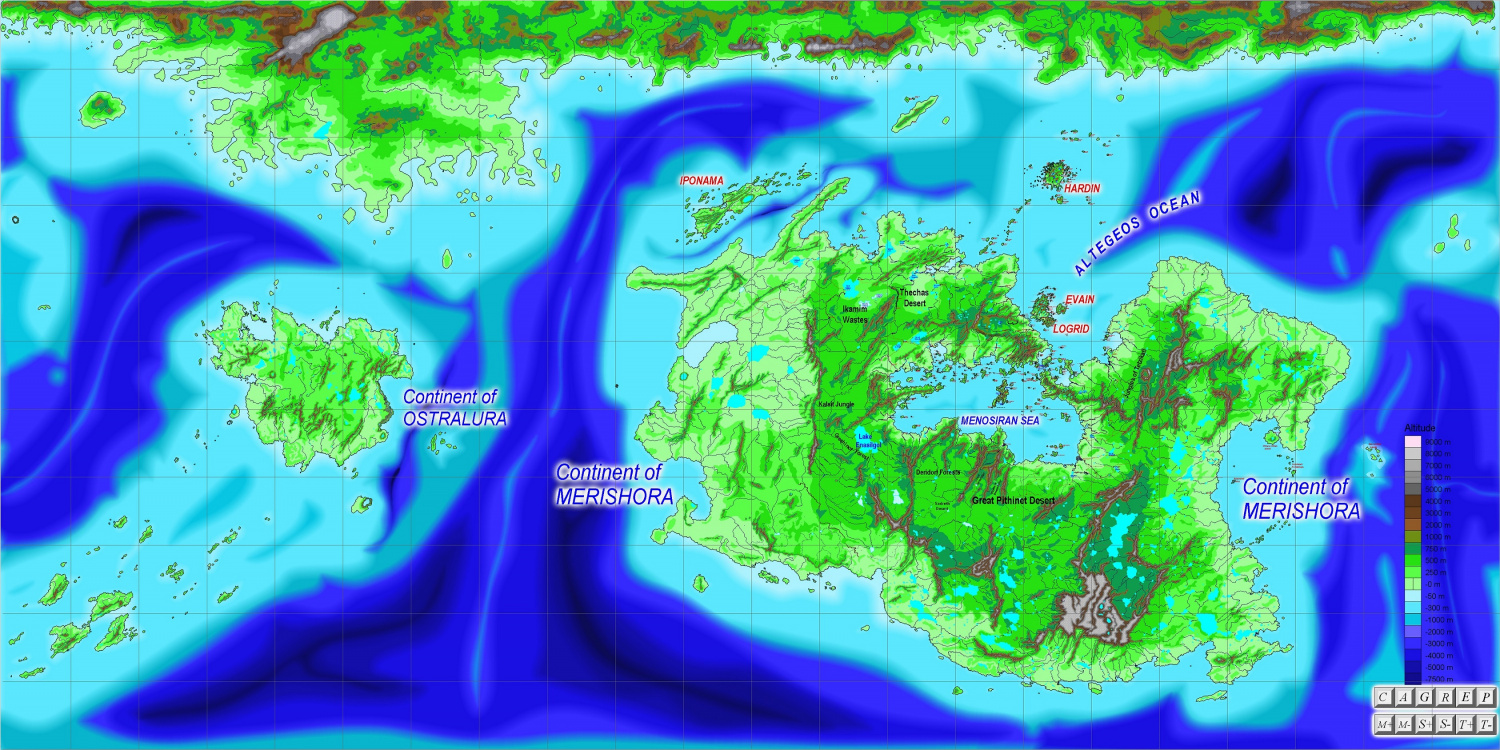
Here is the first map (showing biomes) in an Equal hemispheres projection, which I completed some years ago; and then the current equi-rectangular map, showing biomes and altitudes. Biomes of the northern polar continent not yet complete. The red dots on the equi-rectangular map show which regions I have done.
Equal Area Hemisphere Projection:

Equi-rectangular Biomes:
Equi-rectangular Altitude:
Map showing regions mapped - this will be updated from time to time:

The Biomes and Altitude maps are also in the Gallery at higher resolution.
None of the Regional maps are yet complete, and will be updated.
Comments
Starting from the most northerly one, and going left to right:
Hardin:
Next level (west to east)
Weldarmon and Gyarflags - one of my three main foci:
Deithardt and Kolsven:
Next level down (west to east):
Thechas Desert:
Vottin:
Logrid and Evain - my second focus area:
Erona and Shimerin - site of the Sarapolos Empire of antiquity:
Klemtos and Pelapos - my third focus area, and core of the Klemtan hegemony:
Valparaisia and Iraisia - site of the new capital after the fall of Klemtos in 1855 BKU:
Today's regional; map - The Great Pithinet Desert:
Lots of good work there Quenten. You have your work cut out for you if you plan on mapping every 1600x1600 square.
I am doing 1/day. I will stop once I have a 5x525 1600km sqs done.
I would like your advice on how to handle the poles - perhaps do them as one whole map using the polar projection
That would be my preferred solution for the poles, yes.
Hi Quenten,
Your maps are awesome.
Thanks, Dak.
Just to reiterate - your maps (including the hand-drawn ones) are just superb!
Here is another map - showing the kingdom of Weldarmon (western half) and the Theocracy of Evejheras
And a more detailed map of Evejheras.
Today's map - the Aeifan homeland. Aeifa are sort of elves, without the pointy ears. They are tall, very thin, but with an ethereal beauty (think Keira Knightly). They are quite strong and very athletic. They delight in athletics, and also philosophical discourse. They are long-lived - the oldest elf is over 1200 years old. Because of this long lifespan, they are not too interested in war or competition, but rather are fiercely peaceful (as some would-be invaders have learned to their costs), given to athletic and artistic and literary pursuits - many of the finest court historians and librarians are Aeifa. Some in fact indulge in a hedonistic life, though this is regarded as a little in bad taste by their peers.
Chiefly, they are natural ethericists. Ethericists arepeople able to cast electromagnetic energy from within themselves - many use crystals and wands to help focus and amplify the power; most specialize in one of the seven wavelength ranges - radio, microwave, tetrahertz, infrared, visual, ultraviolet, X-Ray.
Physically, they have long, thin faces, aquiline noses, and oval eyes, usually deep blue, with long blonde and red hair, and very white skin which seems immune from sunburn. They tolerate the cold very well, and have many colonies in the northern climes, even above the Arctic Circle. They are not very fond of the heat though.