

FT3 and The 2019 Annual "One Day Worldbuilder" - Issue with Wilbur steps
 CredePendrel
Traveler
CredePendrel
Traveler
Evening folks.
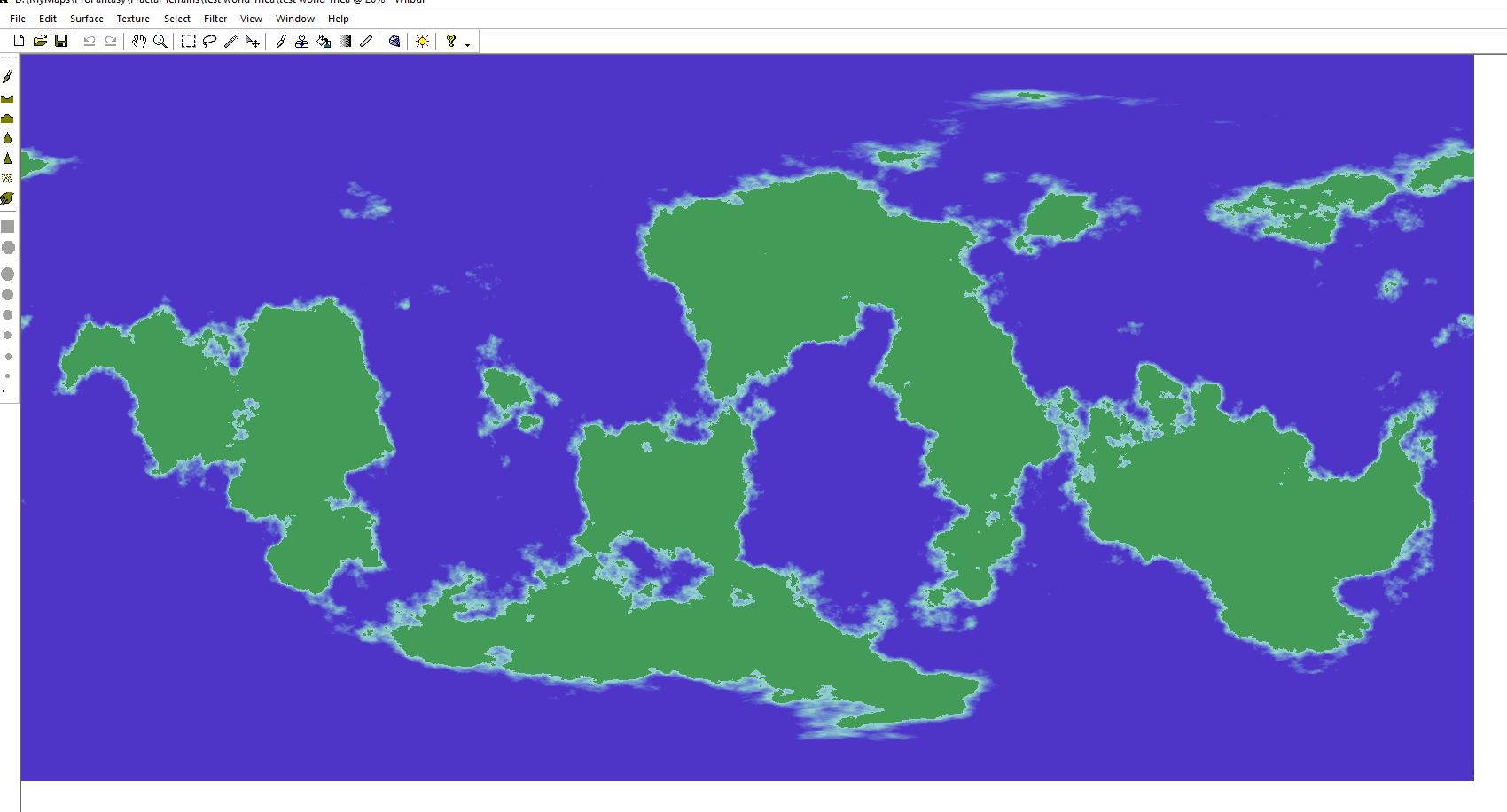
I recently purchased FT3 and the The 2019 Annual for the "One Day Worldbuilder" guide and map styles. I seem to be having issues right away in Wilbur. I can load the .mdr and Flip the map vertically, but cant seem to apply the Wilbur Color Schemes on Page 6 of the user guide.
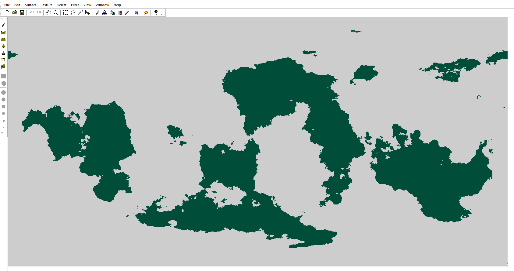
When I apply Wilbur HC Blend - land the whole terrain just turns a flat green colour where I was expecting it to look like the terrain was in FT3.
Does anyone have advice or troubleshooting steps I could try. I have gotten the same results 3 times after opening the .mdr in Wilbur.
- This is what my maps looks like when I import the .mdr into Wilbur
- After applying Wilbur HC Blend - land & Wilbur HC Blend - sea
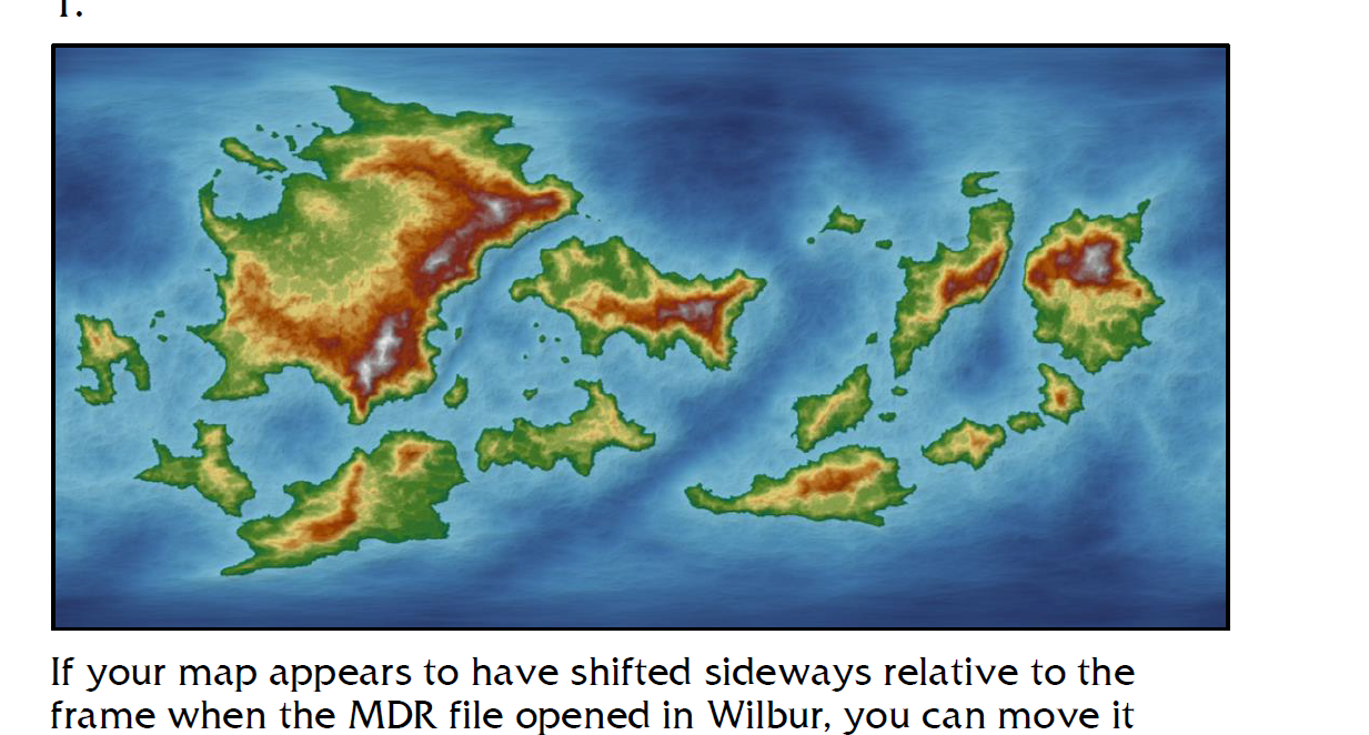
- This is the expect result from the user guide.
Thanks in advance for any advice.
Comments
When the land is flat in Wilbur though you know it wasn't when you were looking at it in FT3, the MDR file has quirky data in it called NANs and Outliers. These are data points that are either massively above or below the expected range of altitudes, or data that isn't a number (Not A Number) - an error of some kind. You can't see these points because they are one or two points in tens of thousands of data points, but you can deal with them by carrying out the instructions on pages 10 and 11 of the Supplemental Notes.
Thanks Sue, you rock! I am already eroding
You're welcome :)
So I managed to get it done, not without a lot of mistakes and backtracking...During the copying/pasting of the contour layers I seem to have lost CONTOURS SEA somehow....The note in the user guide says this part could take a while, and it did seem too, but I had trouble getting the coordinates to 0,0. Each time I pasted it just kept flashing over and over again for like 10 mins.
All in all really good practice, and the potentially here is really cool. Time to try again! (Sorry really had to compress the images to get them onto the forum)
Woot small update...Was able to recover the Sea Contours....
It looks like you've got a good result despite early troubles :)
The pasting in CC3 does take time, but that is because you probably have quite close to the maximum number of nodes for a CC3 map just wafting around on your crosshair. The great thing is that CC3 is nowhere near as crashy as some other software I don't care to mention (but which lost me several day's work just recently by both crashing AND corrupting the file for good measure), it just takes rather a long time to refresh.
You can place the map by typing the origin coordinates on your keyboard and hitting enter once it is ready to be pasted - as you probably did, but then it takes a while for the refreshing to finish and the paste to complete. Patience is all that is required, though :)
Thanks Sue!! I am happy with the update I just posted! Looks sharp.
I had this issue too when I first started using this. Is there any way we could get a sidebar or addendum added to the Annual that explains this and gives the method for fixing it? I think that would be massively helpful.
I did have a follow up question....
When I am in FT and run File - Save Campaign Cartographer File, the export options I see don't match the user guide. BUT I do see the export settings in the Annual directory. How do I get these export settings into FT3?
What I see now...
The export settings in the Annual
@DaishoChikara - it is explained in the Supplementary notes. At the time of writing it appeared that this only happened with the hand sculpted worlds. That is why it is only in those notes. It is only since publication that over a year ago that a very small number of synthetic worlds have also shown these issues. I explain each time and all is well. As to whether 4 or 5 in over a year would warrant an update to the guide would really be Ralf's decision.
Fair enough. I love this community, and there is a lot of "common wisdom" used that doesn't really make it into the documentation. Maybe one day we could make a collection of "known fixes" or some such. Just thinking about ways to make finding solutions easier. ;-)
So it seems like the export settings from the annual should have been saved here C:\Program Files (x86)\ProFantasy\FT3\Export. Once I copied the settings from the annual content here everything is working fine.
Here is another shot of the finished map (almost...gah forgot the rivers) with the correct export settings. The topography is more detailed and the water looks better.
@CredePendrel - The settings should have been installed by the annual installer. I helped you with this on FB, but for the record here is the solution if the settings files do not appear.
Check if they are listed in this folder first:
@Program Files (x86)\ProFantasy\FT3\Export
If they aren't there, go to this folder and copy them across:
@ProgramData\Profantasy\CC3Plus\Annual\Issue 155 - The One Day Worldbuilder\FT3 Export Settings
Then if you have FT3 open at present save your work and re-open it. The settings should now appear.
...
I am not sure why they didn't get installed with the annual. It could be any number of things, like forgetting to install as the administrator. That one comes to mind first because the destination folder is a system folder, and requires admin permission before you can save anything in it.
@DaishoChikara - if only there was time in a life to do such things. But even if you did, the 'Supplementary Tome' would become quite unwieldy - perhaps far more trouble than having to answer the same question just occasionally for new users.
Thanks to Sue I was able to complete these really cool maps for my worldbuilding projects~
I do have another follow up question for this project. I want to create my own export settings and try and increase the number of contours....after creating my settings I get this error when trying to "Enter Setting Name". I was able to modify an existing one and add new contours levels but the settings don't seem to save either; the export looks the same and the export settings revert to what they were before....Anyone have advice?
You've done a great job :)
To be able to save new settings in FT3 you need to have opened it by right clicking the icon and picking "Run as administrator" This is because the folder FT3 wants to save the settings is a protected system folder and you need to have administrator access to save in it.
Hey Everyone!
Looking for some advice for the rest of this project.
Next up, I am looking at detailing the continents individually keeping in the topographic map style (like Nate Mangion's Atlas of Elyden and "Artifexian's Atlas Mapping" https://www.youtube.com/playlist?list=PLduA6tsl3gyjUh9mMXfevCsaDiFKg9I47).
I have selected the continent of Nosiroth as the first to be detailed...Right away I am unsure if I should draw the continent as a whole or select an inset area and focus there first? I spent some time this morning trying to draw political boundaries but got super discouraged as they looked like random lines and not visually appealing. I am looking for advice on how to split the larger Nosiroth region into smaller political entities so I can figure out how many detailed maps I need. Given the current map where would you draw the borders?
vs
I would follow mountain ranges and rivers with boundaries. These are the two most influencing factors where boundaries are naturally established (as opposed to colonists carving it up with horrible straight lines on a map with no thought for logistics of transport, or the traditional tribal lands).
I would be tempted to keep artistic symbols like that lovely mountain range you have there for a different style of map, since the range is already shown by the topographical colours. And now that you have the coastline you could very easily do a parchment map in a completely different style just by copying the land extent across. I understand what you are trying to do with it, because I know Nate's work quite well, but he uses PS and heightmaps, and CC3 doesn't do heightmaps and hill shading like that. If you want the hill shading as well as the contours you might want to consider using an image exported from Wilbur as a background on which to add the political borders, instead?
Thanks for the advice Sue, Ill get to work on these boundaries after work is done for the day. Shoot...didn't mean to post the screenshot with the mountain though....that is part of this project that I had open at the same time lol.
I did some designing last night and tried to layout some content on the map. You will notice that I ignored any actual boundaries for the time being lol.
And a detailed map of the Empire of Eneriar. Its definitely not, the final aesthetic I was after, and not anywhere close to Nates or Artifexian's presentation which I am unsure If I can obtain or not.
It's looking good, Cedre :)
One thing, though. National boundaries like this one tend not to hug the coastline, but trail off into the ocean where the ocean is met. Otherwise how are the Eneriarians to claim their coastal waters?
That's true! And it will look better...will fix that. You can call me Andrew Loopysue lol
Thank you, Andrew :)
Had a bunch of meetings today so I slowly started filling in the world map....Will use a google drive link so that you can zoom right.
URL fixed....
https://drive.google.com/file/d/14Dg8Ifo6vnq26yQ77_7-I1s4W1CCXTfG/view?usp=sharing
I think you need to share it differently to the way you have. I tried, but was denied access.
Same here ?
@CredePendrel Did you know that you can upload a jpg file to your own personal gallery that is up to 5MB? If your map is that size or smaller you can upload it and then link to it from this thread.
URL above is fixed. I used google drive because the image is 28.7 MB