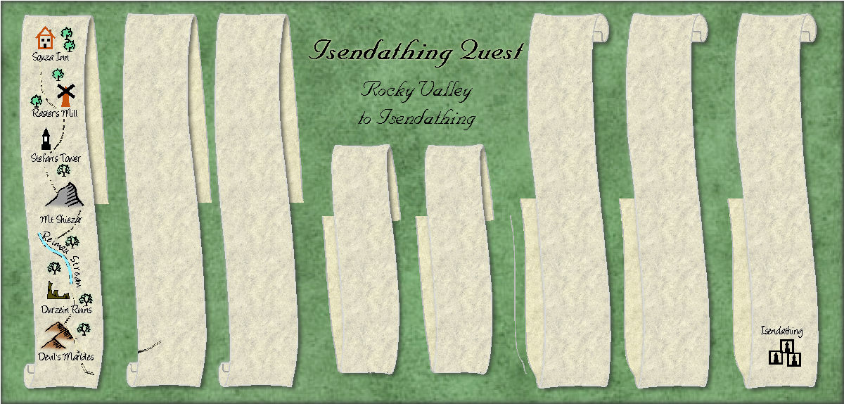
[WIP] Community Atlas - Ezrute - Dunor Valley - Strip map of Journey from Rocky Valley to Isendathin
This is the beginning of the journey required for refugees from the zombie/alien attack at the Rocky Valley Inn to seek help from the Seers at Isendathing, the mystical holy site of the whole region.
I am using Annual issue 29 (2009)
I will be /have already created some more vector symbols


Comments
As a reminder, here is the map for the Rocky Valley region
https://atlas.monsen.cc/Maps/Rocky%20Valley%20Region
i love this style
I love strip maps. They're putting the mapping focus right into the main point of most maps, i.e. how to get from a to b.
Here is the completed map. The direction goes down-up-down etc. The arrows indicate direction.
I have never seen this kind of map before! Mind blown!!
These maps are great as player handouts. I love how they describe the route and let the players know what to look for and what to expect without giving them a complete detailed regional map.
I currently have my players following a river with such a map in hand.
Please feel free with criticism, as I want to submit it to the Atlas soon.
My main criticism is something you probably won't fix (because it would be a lot of redrawing and you probably like it your way), I am not fond of the way you are alternating directions on them. I prefer to read them all from top to bottom.
I also do think it looks better with the continuous strip layout intended by the style rather than splitting them into individual pieces of paper like you have done here.
You are spot on with the first comment (ie, I like it my way ?). As for the second, I have relooked at the picture in the Annual, and it seems that I could fix it by putting the scrolls much closer together. I will try that and repost. Thanks for the comment.
Actually, you have used the wrong symbols to just put them closer together, you need to use the "middle" symbol, you have three "starts" on the left side, and three "ends" on the right side.
Since the ribbons have the same shape, they should be replaceable without too much work though.
Thanks for that. I will definitely fix.
Boustrephedon, no less!
Can't be sure about some of the spellings due to the font being used, but the Atlas maps have "Mt Sheizer", "Duneizen Citadel", "Cult of the Maenads", "Rechtatzen Tor". Also, I couldn't read the second word after "Sturmhund", but it looks too short to be "Citadel".
I appreciate the variant spellings may be more poetic licence as a player's map, not a GM's, but the nature of this map and the multiple original Atlas maps makes following it for a GM difficult enough now, without such variants. If you'd prefer to keep the spellings you have now, I'd recommend also preparing a separate, complete, though more schematic, map for GMs only, so they won't have to struggle so much to keep on top of things and run the game.
Thanks for checking those - I will definitely fix these.
Most of the good criticisms noted and fixed. Please don't spare me if more fixes desired.
Is it possible to mess with the shadows on the strips?
If it is, then does it look better with longer shadows to cast the back of the strips in more shade?
Also, I think some of the labels are escaping into the fresh air over the edges of the strips.
Yes, thanks Sue. I will try to mess with the shadows. Wish me luck
Luck wished :)
Hopefully luck found me.
That looks better. The back of the ribbon looks further back than the front now :)
Great. I would like Monsen and Wyvern to comment before i hand it in.
Not too fond of how the text glow visually looks more of a blob behind the text rather than an outline of the text. I suggest reducing the blur radius, or switching to the Outer Glow effect instead.
Thanks, will do.
Mt Sheizer still needs correcting (currently Shiezer). The "s" in "Pillinger's Peak" is still trying hard to escape the edge, though that may be a rendering effect at this resolution only.
Not sure about the "What the Hell is this?!!" label. Might be better to switch to something more generic, like "Unknown Danger" or "Extreme Caution!" Or indeed remove the label entirely - as the mapped red Xs are already keyed.
@Wyvern That is likely Quenten's humor.
Correction made. I like the What the Hell is this, though.
I would very much like to thank Wyvern, Monsen and Sue for their very helpful comments, which have led to a much better map. I hope you trio will be as helpful with all my mapping endeavours. I have especially missed Wyvern's input recently.
I will write a little map Note, and submit it in the morning.
Here it is - and I hope that is it, but please butt in if you think more needs changing. map note underway.
Note that Mt Sheizer is still showing as "Shiezer".
Map now in the atlas. Thanks for the contribution Quenten.