

Tilkar map
 Medio
Surveyor
Medio
Surveyor
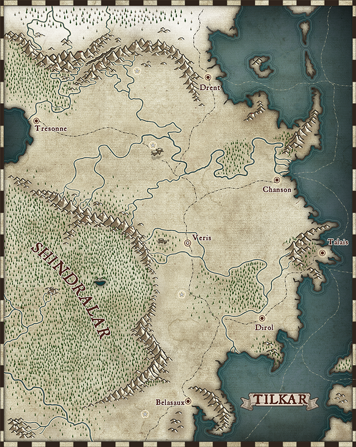
So, i was posting a WIP map some few weeks ago, but i had to stop doing it as i had to travel. Once i came back i gave the map the last strokes. Here it is, hope you like it:


![[Deleted User]](https://secure.gravatar.com/avatar/c75d9a245b74d9c59be0999ea81ca541/?default=https%3A%2F%2Fvanillicon.com%2F92add7f8c954488718110edc4896ad39_200.png&rating=g&size=200)


 and 1 other.
Comments
That's lovely, Medio :)
Came out beautifully.
Got to ask - what are those "floaty stones" about midway between Tresonne and Chanson by the circled star symbol? Are the ones in the woods near Veris the same?
The forests have come out nicely interesting. Were the roughly circular features in places deliberate, or something that just happened randomly? They remind me a little of the woodland spirals from Robert Holdstock's Mythago Wood novels.
Those floaty stones are well, that. Floaty stones. In my campaign world there is a rock called Rocanube (Cloudrock) which is maggical by nature and the more the Cloudrock is beign together, the more it levitates. It can hold even cities (and there are some few spread over the world). Obviously it would be better seen on a regional map but i didnt want them to dissapear as they´re important on my campaign.
Those circular symbols (there is a star inside them) are actually Houses of Mages. Tilkar is a magecracy and wizards rule the country. The Mage Towers are built in special places which have connections with the maggical powers of the world. Now, that connections are lost but the Towers themselves are built with long forgotten maggical knowledge and bury lots of hidden and dark secrets so the wizards keep using them. Some of them are bigger than many cities. The Towers had barriers, an aura of mystical protection which protected them from harm and intrusion. Now the barriers are gone but you still can notice the differences inside those barriers - in rocks, vegetation and more.
Was toying with a forest style. What do you think about it?
Interesting, but in comparison with your existing forests, it looks a little like a marsh on top of a low plateau. If that was the only style of forest symbol though, it would probably be fine.
Being honest, I prefer your individual, variable-tree-size forests on this map, however.
Yeah, was just a test, meaning it would be just one forest style (which are very different ). Maybe for this map the single tree forest look better and more abstract, but also for other kind of maps... will keep toying around!!
Medio has graciously allowed me to use his custom artwork in tomorrow's live mapping session on YouTube. We'll also make them available for download, so you can use them yourself.
Thank you very much, Medio! Very generous of you - and a beautiful new style :)
Damm you Ralf!! Now that people will use it (hopefully) I will have to make more stuff so it has more options... I'm afraid it won't be ready for tomorrow but I promise it will for when it's launched.
I hope to see you at the Live Stream, Medio :)
I'd kill for being there but tomorrow is a crazy day for me, got a course to give on the morning and right after it, no time to eat, have to go back to home to take my wife to an important exam. I will be go back late to home...
Gonna check if I can attend to it on my phone while I wait for my wife to exit.
Good man. Family should always come first.
Good men also need to eat! Let´s see how i figure that out :D
Checking timetable... it could be possible to attend, at least the first part.
Okay, so i will create more symbols and maybe textures for the map. Any suggestions? (remember it´s more a world/realm map than a regional map so small details symbols shouldn´t exist).
Maybe people will ask questions and make suggestions tomorrow during the live stream. It will be easier for them to see what you've already done, then.
I am also quite sure that Ralf would have said so if he felt that the set was in any way unfinished ;)
Yeah, indeed. In anyways i wont start working on those symbols until the weekend so no biggie :)
As we discussed on the Youtube session, this is the font i used for the map:
https://www.dafont.com/jsl-ancient.font
Thank you for this, David :)
And thank you too, for coming along and joining in with the live stream :D
Sorry i couldnt stay up all along. But was great and i learned lots for future maps.
Oh btw, yesterday night after watching the stream i wanted to work more on the style so i did more floating island symbols and some tree symbols aswell for future maps. This weekend i will advance also on figuring ways of doing deserts, swamps and more land features. Stay tuned! ;)
I've just finished watching the recorded Live Mapping video session (the download link Ralf promised has been added there now, incidentally). I noted there that @Medio had mentioned wanting to add river mouth pieces to better hide the ocean-river joins.
I think it should be possible to still use the Color Key Effect to create river lines using the preferred water texture instead of the ocean one as long as you make a copy of the landmass onto a new Sheet below the landmass one and above the background ocean one, and then change its fill style to the selected water bitmap style. That wouldn't get you the pale glow alongside the riverbanks, however. Not sure how that might be best-accomplished without creating the identical problem to the extant one with the river mouths, however.
I already made a River Mouth sheet with effects to make them (will send them to Ralf with the rest of the pack when it´s done). Posting the result (at larger scale obviously they look much better) :
Humm could be worth to try your solution. I also actually want to make a change on the texture so it looks like exactly as the land border.
I think if you use a colour key you will get the desired outcome, and it will give you the same effects as the coast. Though you might not want to do that, since it will also mean that the edge striping will also be applied. It depends how you want it to look - and how much of this is already set in stone as part of the style.
The files I got from Medio and used/created for the Annual video are available via this download:
Just extract the zip file over your CC3+ program data folder to add them to your installation.
Wow! Thank you, Medio and Ralf. That's hugely generous of you both :)
River mouth deltas are a great idea. Thanks !