How do you fix a line that is pixellated?

Hi guys,

I've been searching for a way to fix this but I cannot seem to find anything that can really help.

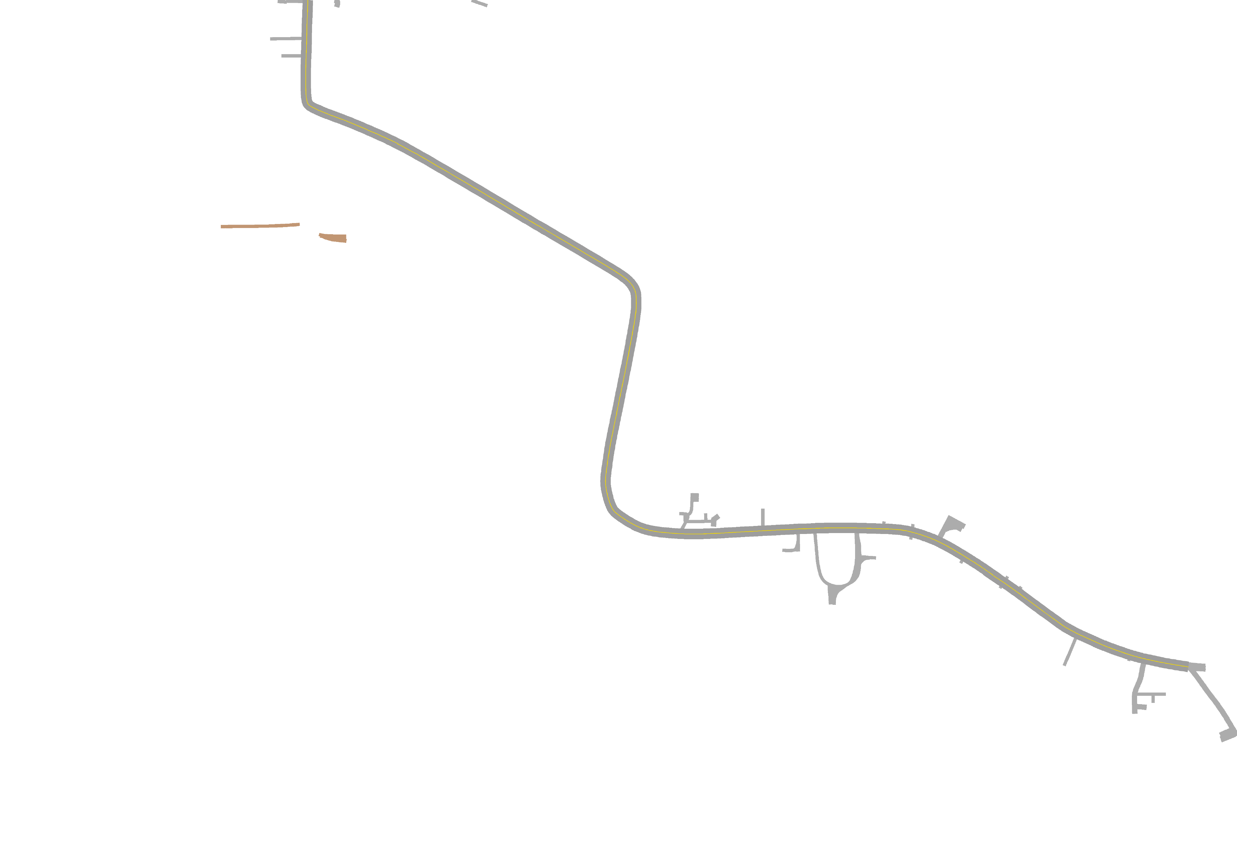
I've got a street that I am trying to build. But any time a line is put on it, the line always seems to pixelate. I wanted the line to look really smooth, just like a real line in the street would look. But CC3+ always seems to draw the line in short little segments that don't want to line up very well without looking like the line its self has shifted to one side or the other.

Here is a picture of what I am talking about. Notice how the yellow line does not have smooth edges? Any ideas how to make it look more natural? Like a line painted on the street normally looks?

Thanks for any advice.
«1

Comments

  • JMunsonIIJMunsonII Traveler
    What happens when you zoom in?
  • If you zoom in, the line is still pixelated. you can zoom in for a while and no matter how far you go, it remains that way. But when you get too far in, then the whole map starts to pixelate. It is almost as if CC3+ is drawing a short line, then shifts over a little bit before drawing the next one, then shifts over again etc. All of that shifting is giving the impression of it being pixelated.
  • MonsenMonsen Administrator 🖼️ 46 images Cartographer
    edited May 2017
    This will always be a problem with an angled line on a computer screen. Because the pixels of the screen (and in an image) are lined up in neat rows and column, any line going at an angle will have to consist of short straight stretches that shift over one pixel at a time. The better the DPI of the scree, the less noticeable this becomes (and for an exported image, the higher resolution it was exported in, the less noticable)
    The usual way to combat this problem is to use anti-aliasing. CC3(+) has an option for this in the export dialog. What anti-aliasing does is that it blends the colors of neighboring pixels to create an effect that make angled lines look more natural to the human eye. It is still noticeable if you zoom far enough in, but it looks much better. Try an anti-alias setting of 25% or so.
    A slight blur effect can serve the same purpose.
  • Is the fill of the line Solid, or a bitmap fill? (use List to check) I don't have problems with solid fills.
  • My anti-alias is always set to 25% when I export because I try to keep the edges on things a little more smooth. I just thought this one was being ridiculous though. It is the actual symbol for a road with a yellow line from CD3.

    I am just really surprised it turned out like that because I usually don't have a problem with this sort of thing. What is worse is that if I add a blur effect to it, before it actually makes the boxyness of each little line go away, it will blur the line so bad that the road just looks yellow instead of like gray cement.
  • MonsenMonsen Administrator 🖼️ 46 images Cartographer
    Thin lines like this are always more difficult to deal with, aliasing-wise (In any program involving computer graphics, not just CC3) because you simply doesn't have enough pixels to work with. You'll find that it looks much better if you zoom in to a smaller stretch of road and just export that, because the line will be much thicker, so anti-aliasing wil affect it better.
    You could change the anti-alias setting further, although this will affect the maximum resolution you can export it as.
  • JMunsonIIJMunsonII Traveler
    Posted By: TonnichiwaIt is the actual symbol for a road with a yellow line from CD3.
    That, I think, is the whole problem...
  • edited May 2017
    Posted By: JMunsonII
    Posted By: TonnichiwaIt is the actual symbol for a road with a yellow line from CD3.
    That, I think, is the whole problem...
    Well, I also laid down just a regular road and then added a line to it with the freehand drawing tool and I got the exact same results, so it is probably exactly what Monsen was talking about. That is unfortunate because now I am probably going to have to go in there and manually make very short sections of the line in the road just to make sure it does not pixelate out. If that will even work. And lining it up after every single section is going to be a major pain.
  • This is probably a crazy idea, but what would happen if you changed the line colour to be the same as the road - so it became invisible - but set it up on its own sheet so you could add a yellow glow to it using the effects? I know this works for adding a thin coloured line at the edge of map contours is all.
  • JMunsonIIJMunsonII Traveler
    BTW, I did look at the OP image and it seems quite acceptable to me. Given that we are working with "computer graphics," the medium does have its limits (pixelation is a symptom) and I think you've approached them in this case. Are you certain you aren't splitting too fine a hair here?
  • LoopysueLoopysue ProFantasy 🖼️ 39 images Cartographer
    How about drawing it with vectors (instead of bitmap symbols), and rendering it out twice the size you want the finished article, then reducing the exported image to the size you really want it to be in an app like GIMP?

    I've always used that technique to take advantage of the bicubic downsampling, which does away with all the usual pixilation problems - antialiasing on a grand and spectacular scale that beats any other technique hands down.

    Don't think I've ever uploaded a map either here or at the Guild that hasn't been bicubically downsampled by at least 50% from the exported original. Most are only 33% or 25% the original. Because I do it that way I don't even use the built in antialiasing in CC3, which means I can export an image up to 10000 x 10000 pi, and it actually be that big, rather than having to compensate for the built in antialiasing by reducing the size of the export.

    Hope that makes sense :)
  • DogtagDogtag Moderator, Betatester Traveler
    edited May 2017
    @Tonnichiwa: Out of curiosity, with all this talk of screen resolution, how are you planning to use the map? I ask because, if you're planning to export it and use it as an image, that's one thing. But if you're planning to print it then this might be less of an issue since printers generally have much higher quality output than most computer screens (300+ dpi print vs. ~96 "dpi" screen).
  • LoopysueLoopysue ProFantasy 🖼️ 39 images Cartographer
    LOL! Don't worry, its all quite simple really. I'm just not great at explaining things ;)

    Bitmap graphics are pixelated. That's what they are - a rectangular patch of pixels that happen to generate a picture of some kind.

    Vector graphics are not pixelated because the vector is a straight line through virtual space between two virtual points. They only look pixelated on the screen because the screen itself is just a giant animated bitmap, and therefore pixelated.

    To get over the pixilation of vector drawings caused by exporting them as bitmap graphics (png, jpg, etc), you need to export them at about twice the size you want to end up with. For example Merelan City was always exported at 5000 x 5000 pixels from the CC3 map, and then this exported bitmap was opened in CorelDraw and scaled down to 2500 x 2500, or 1250 x 1250. The method used to scale down a bitmap image usually involves something called downsampling, which has the effect of super-antialiasing any ragged edges.

    I'll go prepare an example. For some reason MC is taking a bit longer than usual to open up, but I won't be too long I hope :)
  • MonsenMonsen Administrator 🖼️ 46 images Cartographer
    edited May 2017
    Posted By: LoopysueDon't think I've ever uploaded a map either here or at the Guild that hasn't been bicubically downsampled by at least 50% from the exported original. Most are only 33% or 25% the original. Because I do it that way I don't even use the built in antialiasing in CC3, which means I can export an image up to 10000 x 10000 pi, and it actually be that big, rather than having to compensate for the built in antialiasing by reducing the size of the export.
    So, you basically takes CC3+'s single step process and make it into two? This process is basically what CC3+ does for you automatically when you have antialiasing on, it exports it at a larger size, then resamples it down to the size you requested. For example, with 50% antialiasing, it exports the image at twice the requested size and then resamples it down. The max export size ends up being the same in any case, because you need the same size export whether you wish to resample manually, or have CC3+ do it for you.
    You do get a couple of advantages by doing it manually though, like being able to select which algorithm to use, and easier to experiment since you don't need to render it for each try if you start with a big enough export in the first place.
  • LoopysueLoopysue ProFantasy 🖼️ 39 images Cartographer
    Yes that is basically what I mean. Meaning no offense, but I like to play around and get the best algorithm rather than leaving it to chance that it will just 'happen to look right' if I leave it to CC3. I'm not even sure that CC3's antialiasing is bicubic? It doesn't look the same as the bicubic downsampling I use in GIMP, or Corel Photopaint.

    Still trying to get Merelan City to cooperate so I can produce an example....
  • LoopysueLoopysue ProFantasy 🖼️ 39 images Cartographer
    edited May 2017
    Here is a series of 3 images for comparison:

    Rendered directly from CC3 without any antialiasing..

    [Image_8511]

    Rendered directly from CC3 with 60% antialiasing...

    [Image_8512]

    Rendered at 2.5 times the size without any antialiasing from CC3, and then downsampled in Photopaint to the same size as above...

    [Image_8513]

    Perhaps this wasn't a terribly good example, since there is so much going on in this map, but I can see the last map is somehow sharper than the equivalent export direct from CC3 with the 60% antialiasing. I may, however, be biased in my view ;)
  • HadrianVIHadrianVI Surveyor
    Remy, don't you do the same thing with the atlas maps? Export them in a very high resolution and reduce the size then for the non hi-res version of the atlas?
  • MonsenMonsen Administrator 🖼️ 46 images Cartographer
    Posted By: HadrianVIRemy, don't you do the same thing with the atlas maps? Export them in a very high resolution and reduce the size then for the non hi-res version of the atlas?
    Yes. I render the high resolution ones in CC3+ (they are all rendered at a size of 8192 pixels along their longest edge, with a 25% antialiasing, for an actual render size of 10666 pixels). These are the ones downloadable from the high resolution button. Then I resize these down to 1280 for the ones displayed in the map browser. I am letting the software pick the downsample algorithm, this usually results in a Bicubic algorithm being used.
  • Wow, a lot has happened since last night. Thank you everyone for trying to help.

    To give you all a more clear picture of what is going on, I got contacted by someone who saw my stuff over in the commissions thread and asked me to produce a map for them. They wanted me to make them a map for a zombie apocalypse type game based off of a map from Google Earth, and they wanted to be able to edit the map later. So they bought CC3+, CD3, SS1, SS3, and DD3 so they could edit the map in CC3+ and also so they wouldn't see any red "x" s when I finally send them the FCW.

    Everything was going great, until I ran into this little problem here. It isn't going to look so great if I send them the FCW and the map has that nasty looking line in the middle of the street like that, so I'm looking for ways to fix it.
  • LoopysueLoopysue ProFantasy 🖼️ 39 images Cartographer
    edited May 2017
    Are we to assume that the first thing you send them is the jpeg export, and that when they get the FCW file they will only be using it now and then to modify the map, but will at all other times be using the bitmap export to play their game on?

    Assuming that is the case, then even though they will see the ragged effect on the screen when they open the FCW file, they will already have seen the antialiased jpeg you send them first, and then once they have been taught how to export the bitmap properly with an appropriate amount of antialiasing (about 50% by my reckoning for a reasonably smooth result), they will only see that ragged edge in the FCW, and not on any of the exported bitmaps - the bitmaps being the product, and the FCW file being merely the tool that will allow them to modify the product.

    This on-screen jaggedness while viewing the CC3 file is just part of using CC3. You could if you like mess around with the resolution settings in CC3 itself. That might give them a better image, but its really something that can't be changed. Screen resolution is only 96 pi/inch, and that's just how it is *shrug*
  • I'm honestly not sure at all how they intend on using the map. From my end though, I am sending them the PNG of the map. They won't get the final FCW until the end. So it has to look good on the PNG I am sending them first. They're paying for it and I wanted it to look as good as I can get it.
  • LoopysueLoopysue ProFantasy 🖼️ 39 images Cartographer
    You should be able to get a reasonable png by increasing the antialiasing to about 60%, like I did with the samples above :)

    I wouldn't go any lower than 50%
  • Hmm, ok, I'm trying 60% as type this....ugh! 86 passes before it completely renders!..I'm gonna be up late tonight!
  • LoopysueLoopysue ProFantasy 🖼️ 39 images Cartographer
    Good grief! How large are you exporting this thing!

    I only have to do a couple of passes, even when I do the full 10,000 x 10,000 pixel render out!

    That really doesn't sound right at all.

    This is one of the reasons I export without antialiasing and then do it in Photopaint or GIMP - CC3 really slows down badly with a lot of antialiasing going on.

    btw - when you increase the antialiasing, don't forget that you have to reduce the size of the export so that the actual limits are no greater than 10,000 pixels in either direction.
  • LoopysueLoopysue ProFantasy 🖼️ 39 images Cartographer
    is that including the antialiasing? I mean is that the total height and width shown in the boxes next to the AA box?
  • jslaytonjslayton Moderator, ProFantasy Mapmaker
    Posted By: LoopysueGood grief! How large are you exporting this thing!

    I only have to do a couple of passes, even when I do the full 10,000 x 10,000 pixel render out!

    That really doesn't sound right at all.
    You have increased the MaxPixelsPerPass value in your CC3PlusCfg.xml file, haven't you, Mouse? That would cut down the number of passes required dramatically.
  • No, it was a lot bigger than that. Somewhere around 13000. Anyway, it is already done! and 60% made it good enough that it will work. Thank you!

    And thank you everyone else for all of your suggestions and questions.
  • LoopysueLoopysue ProFantasy 🖼️ 39 images Cartographer
    Posted By: jslayton
    Posted By: LoopysueGood grief! How large are you exporting this thing!

    I only have to do a couple of passes, even when I do the full 10,000 x 10,000 pixel render out!

    That really doesn't sound right at all.
    You have increased the MaxPixelsPerPass value in your CC3PlusCfg.xml file, haven't you, Mouse? That would cut down the number of passes required dramatically.
    Thanks Joe :)

    I did that ages ago to get a render artefact to vanish on my Merelan City map. Ralph told me how to do it.

    I think Tony might need to do it to cut down on his '86 passes', but I don't know if he's using CC3 or CC3+ (if that makes a difference) :)

    I also can't remember where the instructions went to, to be able to tell him where it is and which number to add the zero to!
Sign In or Register to comment.