

[WIP]Fantasy World Map - 13th Age Style
 HadrianVI
Surveyor
HadrianVI
Surveyor
Hi
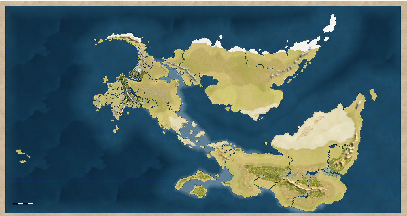
The gorgeous map Medio posted some time ago inspired me to give it a try with the 13th Age Style.
This is a work in progress, so it is not nearly finished.
I wasn't able to attach the map in a larger resolution. Therefore I added some screenshots of the western part.
Cheers
The gorgeous map Medio posted some time ago inspired me to give it a try with the 13th Age Style.
This is a work in progress, so it is not nearly finished.
I wasn't able to attach the map in a larger resolution. Therefore I added some screenshots of the western part.
Cheers
Comments
I mostly used real world maps as inspiration for the coast lines. I also tried to imagine how the fictional tectonic plates in my world would behave in order to determine the rough shape and position of the continents.
The mountains are actually the ones from 13th Age but I used the tutorial from the "shaded relief" style (from the 2008 Annual I think) in order to give them the look I wanted. I was quite frustrated with the mountains that come with the 13th Age Style at first, especially after seeing your mountains, dear Medio. And since I do not have any useful graphics software (yet), I had to find some way to make them look okay by using the means CC3 has to offer. Luckily I then stumbled over the "shaded relief" style.
The key was to add a lighted bevel effect to the Mountains Sheet and toy around with it. Sometimes (like in the western part) I had to draw two mountain ranges (each on a separate sheet) on top of each other in order to get the results I wanted. I then also started to use this effect, which I have never used before, for non-mountain stuff:)
Cheers
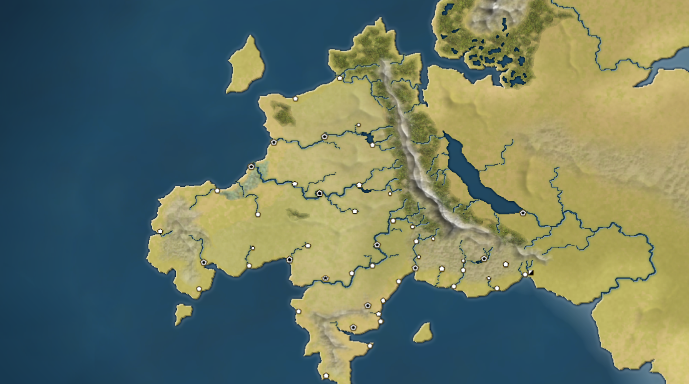
here's an update on the World Map I started back in February in CC3 because the 13th Age style was not available in CC3+ at this time.
Unfortunately CC3 used to crash every 5 minutes, which is why I eventually gave up on the map, when I started contributing to the Community Atlas.
Now, I started to create the world map in CC3+. The shape of the continents is not exactly the same and I have only drawn the western continent to far.
The picture below shows the same area as the second picture posted in this thread, but the region is still far from finished.
I focused mostly on the mountains and on the rivers that derive from the mountains. But neither the rivers nor the mountain are completely done yet.
Also, please note that the fills are not yet optimized for an export in the resolution I used (I exported it in 4096x4096, then I've cut of the northern and southern end of the map).
Cheers,
Hadrian
The mountains are actually done with the same technique, they are lighted bevel Mountains. The difference between them are 6 months of practice ... and a couple more sheets
Cheers,
Hadrian
@pixelkitteh: Thank you! I reworked the mountains in the northern part, because they were a bit too slim in some instances. The mountain range is supposed to be a natural barrier. What do you mean by "the coast is so simple"?:D
@Barliman: Thank you. I'm trying to get a realistic topography and I've spent quite some time reading up on the development of mountains and all this stuff. The mountains range here is supposed to be similar to the Himalaya and the Alps. The Sierra with the Lakes is roughly inspired by Tibet, but mine is supposed to be much lower, still allowing for large pine forests.
The region in the South with the rivers is called Demetia. There are more small rivers (that do not originate in the mountains) to be placed in Demetia and elsewhere, but first I am going to finish all the Mountains and their rivers on the continent.
@Shessar: Thank you. For the rivers, I tried to stick to the Stralher-Number-Rule, that says: the width of the only grows, if two equally sized rivers join, but not, if a smaller river flows into a larger one. There's a forum thread on Strahler Number Rivers: http://forum.profantasy.com/comments.php?DiscussionID=7116&page=1#Item_2.
The ocean fill and the sheet effects of the landmass are the standard ones from the 13th Age drawing style, so I can't really take credit for that. The landmass fill is the Mike Schley Land fill with an "Adjust Hue/Saturation" effect to reduce the lightness.
Now, here's another update. This map covers a larger area, which is still quite empty so far, so I covered it up with parchment.:D
BTW: The fine white horizontal lines you see, are the markers for 30° and 60° degree of latitude. The fine red line almost at the bottom of the map is the equator.
Cheers
Hadrian
Here's some more of my simple coastline
The coastline is shocking great. I wanna play there!
*doffs cap*
I was going to response yesterday with an individual response to each of your comments. But unfortunately I left the side before I finished the post, so it got lost. So here's the recap:
@Quenten: So far I managed to avoid Armageddon but during the last redraw there was an Ice Age:P
@Jensen: Thank you. The good news is: You shall get the chance to play there. I plan to release detailed maps of the world together with the novel, which takes place there. The bad news is: It might take a couple more years until I get there.
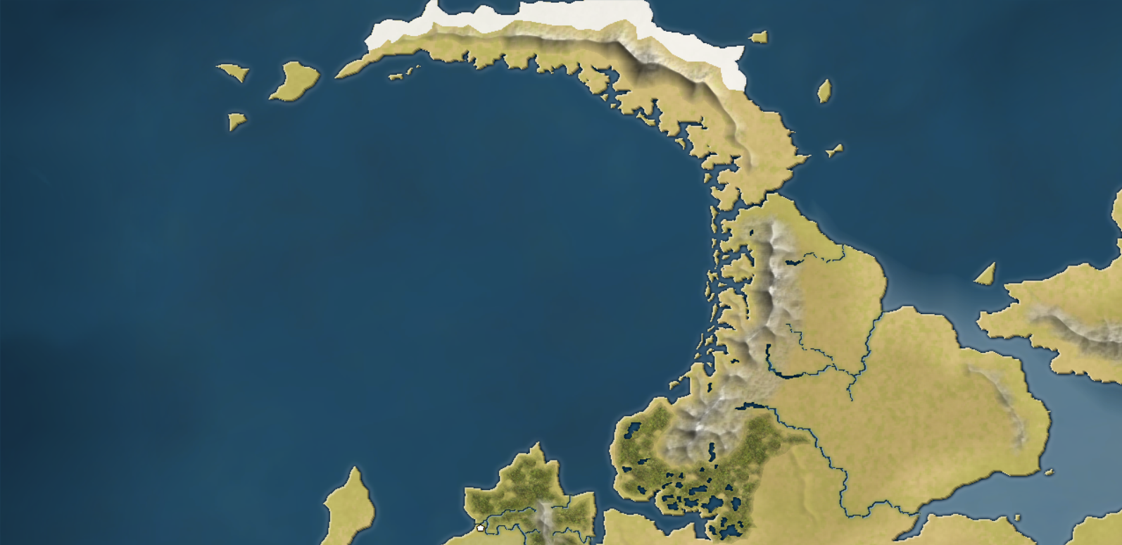
@Dogtag: Thank you. I really appreciate that you recognize the amount of work that went into this. These mountains were the hardest ones to do yet, because unlike the alpine kind of mountains in the south the ones in the north are much older and therefore much more eroded. And it took quite some time before I managed to create a satisfying impression of this.
@Barliman: Thank you. I spent quite some time studying maps of the Norwegian Coast:)
@Fex: Hi and welcome to the forum. The effects on the Land Sheet are the standard ones from the 13th Age style, as I have already mentioned. If the effect does not appear as strong on your maps, then it is because the effect units are in this case per default "percent of drawing width". If you have a map, that resembles more or less the regions I zoomed in to from my continental map, the effect will look smaller, because the entity on the Land sheet will be smaller than in my case. In the zoomed in renders, CC3+ still takes the whole continent as base for the effect, even though one can only see one small part.
As for the mountains: I posted a tutorial on how I do this kind of mountains in the forum (http://forum.profantasy.com/comments.php?DiscussionID=7345&page=1#Item_15). This explains the basic technique. You don't need any addons. Everything can be done in standard CC3+.
I will certainly continue updates. But I reserve the option to post some of the more advanced and detailed maps as whispers to only the active forum members as yourself. This will mostly affect detailed maps that show areas relevant to the plot of my novel. So, the updates I post publicly will show areas that are less relevant to the plot of the novel (which does not mean that they are irrelevant to the world itself or its history).
Anyway, the region shown in this update is not of great relevance for the story or the history of the cultures in my world, because it is an unfriendly type of terrain. Situated north of the arctic circle, its climate does not allow for larger human populations. There might be a few whaler outposts on the western shore set up by the the north men living further south and some small settlements of the local native people that lives off seal and whale hunting. On the plain to the east one can find Nomads that live off reindeer breeding and even further to the north, where it is too cold for reindeer, there is said to be a people that does cattle-breeding with musk ox.
If you look at the previously posted picture, the lands shown in this update are found in the northern part of the previous picture.
I hope you like it:)
Mike
@Gathar: The sea colour is not chosen on purpose. What you see is generated by the effects on the land sheet, which are still the standard sheet effects from the 13th Age style. The LAND Sheet in the 13th Age style comes by default with 3 effects. A slight bevel effect, which I intend to keep and two glow effects, one short dark glow and a wider light blue glow, that is supposed to create the impression of shallow waters. As far as I assume, the dark glow is supposed to further emphasize the coast line, which works really well, on a higher zoom level. However, it does not work well with Fjords, because they are to narrow. Therefore I will get rid of the glow effects and replace them with a more sophisticated impression of shallow waters.
Now, here's another update. It shows a straight that has been formed by a continental rift much like the East African Rift System. This region is important for the history of my continent because the strait is strategically important as it is the only route to the northern ocean that can be used during the entire year.
As always, this is still a WIP
This is the third attempt to get the mountains look the way I want them to look and so far I am quite satisfied with the result:)