

mapping the Valles Marineris on Mars ?
 JimP
🖼️ 280 images Departed Legend - Rest in Peace
JimP
🖼️ 280 images Departed Legend - Rest in Peace
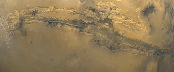
I have an oribital photo made by NASA. I want to combine hiking with a fictional set of hikes in this Martian valley.
Here is my problem, I know the length of the valley, 3000 miles, but I don't know how wide the thing is. I can get the png imported into the map template, but it looks distorted. So I'm evidently not getting the width correct.
I'll attach both the png and the map I'm trying to import without distortion into it. I have shrunk the png by 50%, its 1177 x 491 shrunk down to 589 x 246 to display it here.
I'm not going for super detail, but more like a 'basic look'.
Any help appreciated !
Comments
A Google search on Valles Marineris dimensions yields a couple of different, but mostly similar, answers.
I have been thinking about a 'block diagram' type map, which is what I meant by 'basic look'.
Probably don't need the photo to trace it, but just do the blocks...
Not like a program logic diagram, but [Joe's hostel] walk 25 miles northwest, you will find a campsite and a water source. With a small building for the hostel and a tent with blue spot next to it for the campsite and water source.
Why am I starting another project ? Road blocks in my imagination for the other projects.
Hope that helps
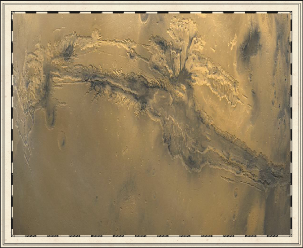
Map length 3400 miles and Map height 1420 miles and insert that picture and see what happens!
I'll try your suggestion Mappy.
Edit:
Aha ! That looks much closer !
Intermittent and water year around. A few hostels and shelters. One overlook. I'll put in some 'heights' later on, off to lunch.
I think an intermittant zone, and a small water, lake would be good at the low point.
I guess that if Olympus Mons erupts then part of the genesis project would have to be to re-melt the core of the planet and rejuvenate it?
The experts reckon that Mars once had an atmosphere, but that when the core solidified (which happened faster than it will on Earth because Mars is smaller), the atmosphere was no longer protected from the solar rays by the magnetic field (which failed with the freezing of the core), and was eroded away by the solar rays.
I've probably made a completely laughable summary of what I remember seeing on all those documentaries in the days I actually had a TV (10 years without one now), but basically to terraform a planet with a frozen core it would be necessary to 'rejuvenate' the core to a molten state.
All this has got nothing to do with your map, of course, which is looking great
Thanks for the map comment.
I'm not sure the addition of hill symbols really adds to this map. It had a kind of clarity, of purity, and I believe those symbols don't really fit the way you draw it.
Unfortunately, I was going to say sort of the same thing as Gathar. I think the map is excellent, but its a top view map and the mountain symbols just look out of place.
Personally I like the map. I agree the hills seem out of place but I also view the map as something from a brochure so they don't affect my perception of the map as much as they might otherwise.
Cheers,
~Dogtag
I typically put the text sheet so it draws after the grid sheet. I'll check on it.
The size estimates for the Valles Marineris in various publication vary precisely because, as already commented above, it depends exactly what you're trying to measure and where from. It's really not helped as a couple of online images I came across showing outline sketches of North America and Europe superimposed on images of the Martian surface don't even show the same relative scaling of the canyon features.
However, and more for the guidance of anyone else who comes across this topic and who might be interested, than in regard to JimP's now-finished map, I did find an interesting geological article online from 2014, An ancient glacial system in Valles Marineris, Mars, in which Image 1, a drawing of the main canyon with the various probable glacial effects highlighted, like ice-flow directions, seems quite close to what was originally requested here - a basic map with a scale.
But of course, I came across a lot more than that in searching, as you do, and thought folks here might especially like to take a look at Eleanor Lutz's blog posting from February 2016 Here there be robots: A medieval map of Mars, which is exactly what it says, a hand-drawn, medieval mapping style version based on mapping data from NASA. Eleanor Lutz will happily sell you a copy of her map in various forms from a link on that blog, but if you just want to admire the artistry in greater detail as an inspiration for your own mapping in CC3/CC3+, I'd recommend the Daily Mail's webpage on the story, as one of the images there is a close-up of the Valles Marineris area. I was especially interested in her use of hatching to indicate steep slopes and to highlight some of the selected contour lines, as this makes the whole come alive a little more for me.
I do like Jim's map here too though, as it's very much in-keeping with other hiking trail maps you can find online these days.
I can't wait to see it