

The Isolate Isles - WIP
 Lorelei
🖼️ 46 images Mapmaker
Lorelei
🖼️ 46 images Mapmaker
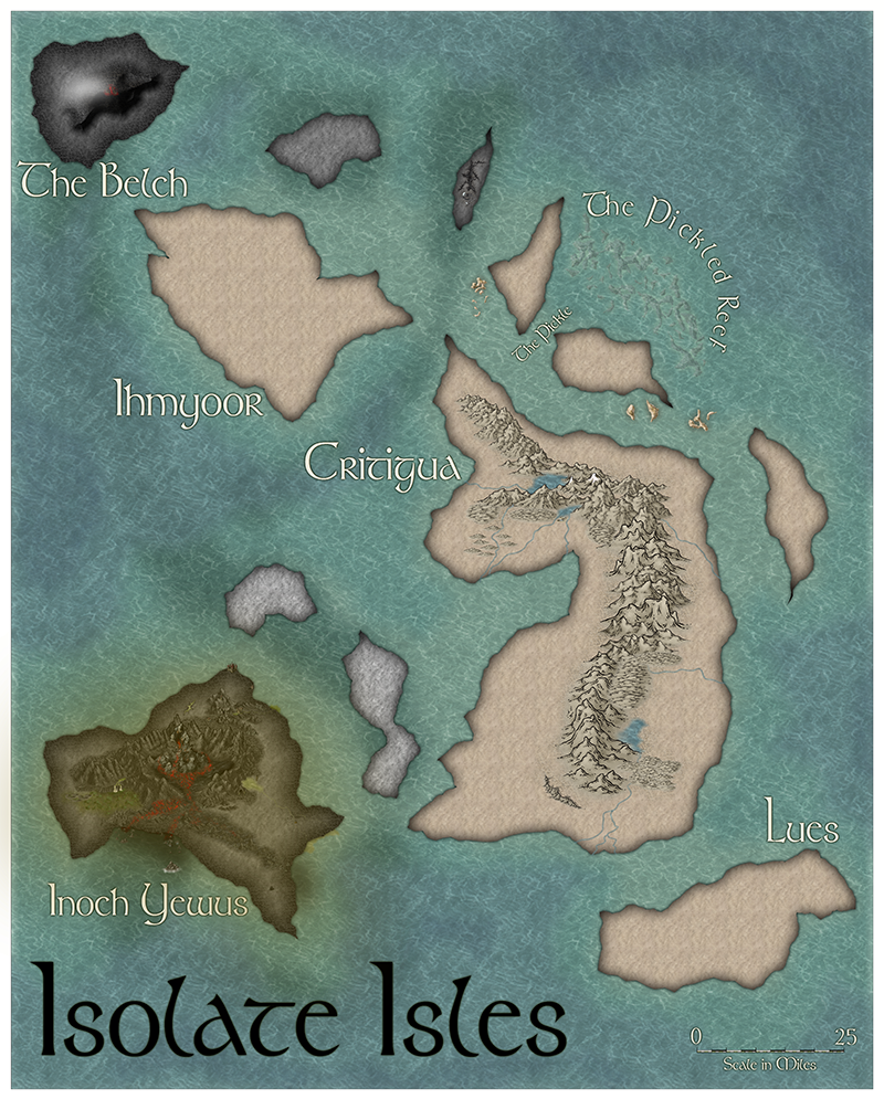
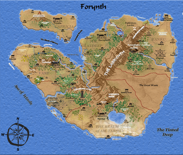
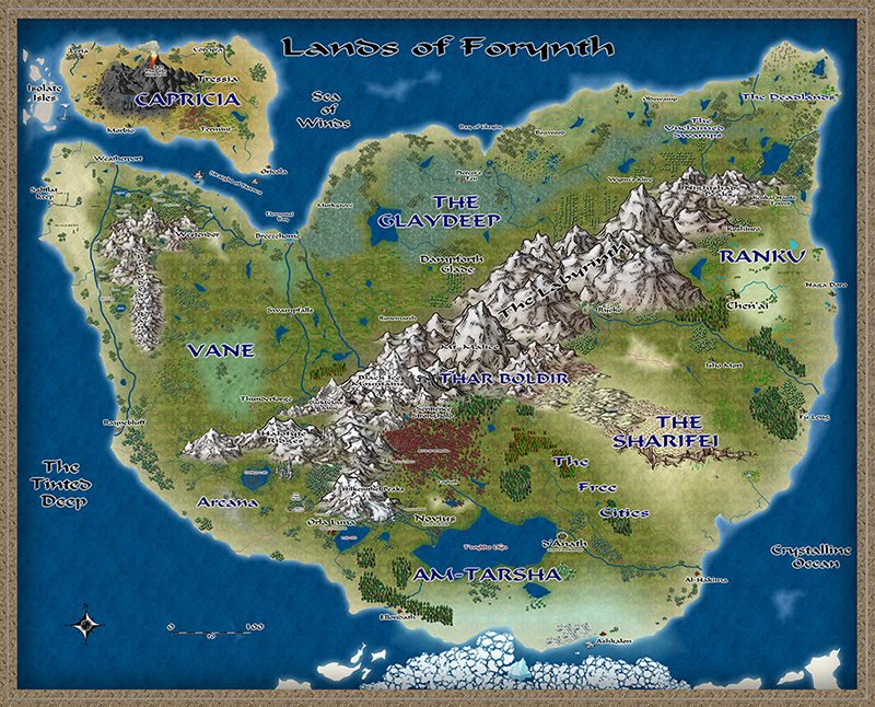
SO, i've had this island chain mapped out for months and months. The last couple of weeks i have picked it up and down. I figured i'd post it halfway finished for some suggestions, comments, tips, etc. from all of you. We all seem to have such great ideas that i relish in your suggestions. Anyway, Forynth was my VERY first map of my homebrew world on CC3+. I made it about a year ago off of my VERY first map EVER with Photoshop. You can certainly see my progression ") I would LOVE to redraw Forynth and Capricia in the H.W. style, especially as my players keep jumping around and i am just adding more and more to this current map - which to my progressed skill in cartography sees that first map as flawed in so many ways. But THAT is a huge project and with the campaign in full swing....well, i'll get to it someday. In the meantime, i've been working on this map of the Isolate Isles to the west of Capricia. I've made some changes based on some techniques i picked up from Sue and some others here over the past week or two...but here it is in progress
I would LOVE to redraw Forynth and Capricia in the H.W. style, especially as my players keep jumping around and i am just adding more and more to this current map - which to my progressed skill in cartography sees that first map as flawed in so many ways. But THAT is a huge project and with the campaign in full swing....well, i'll get to it someday. In the meantime, i've been working on this map of the Isolate Isles to the west of Capricia. I've made some changes based on some techniques i picked up from Sue and some others here over the past week or two...but here it is in progress
Comments
I have a couple of suggestions, I hope you don't mind:
Have you thought of using a very slight blur on those ocean layers just to kill that jazzle effect where the paler lines on each piece are interfering with each other just a bit? Either that, or adjust the scale of the texture to reduce the effect?
If you want to pull the islands together in terms of style, you could try using the same base texture for all of them, even if you end up covering most of the land in different forest/desert/grass textures. The fade inner edge around those additional textures on the land will mean that all the coastline will be a uniform colour for the first couple of mm in from the sea.
The other thing I notice is that although the volcano is a beautiful drawing, it happens to be top view, rather than side view like the rest of the HW set, which makes it look a bit 'odd-man-out'.
I do hope you don't mind me being so "straight to the point" here, but I'm quite tired. I'm just making the most of the time I have to do stuff like this, even though its way past my bedtime!
They are all lovely maps. Its just that you asked for ideas
Dropbox link for Mark: https://www.dropbox.com/s/lphoawcl2dcd8ri/Isolate Islands.PNG?dl=0
Is that lava bleeding into the sea from Inoch Yewus?
Thank you!!!
I know what you mean about the HW volcano. I love HW, but the volcano definitely isn't the strongest point. I tend to use it in conjunction with the volcanic rocks and sometimes black varicoloured sea rocks to create a nasty jagged field around it. Having lava texture seep out of the ground around it seems to help by suggesting the area is generally volcanic in a big way. Alternatively you can use the lava texture to create the core of a really massive volcano at the heart of a ring of black varicoloured ordinary mountains?
I do seem to be a bit fond of these black varicoloured suggestions tonight. I really must go to bed.
Your off to a really good start with it all, anyway
Dropbox link for those who cannot access OneDrive:
https://www.dropbox.com/s/m97yxbkiu4ll6e1/Isolate Islands no film.PNG?dl=0
I'm glad you removed the green smog effect from Inoch Yewus. It was just a bit distracting
I also see now, that you have used a mixture of bevel mountains (the volcano to the north and the picked reef - also the mountains on the tiny island between those two features?) with standard mountain symbols. That's interesting. I think when I did the Ethran map (the one with the shadow of eclipse shown on it), I decided to use bevel rather than the standard mountain symbols throughout the map because I was getting transparency acne in the eclipse shadow. Since there wasn't much land outside the shadow I just stuck to using the bevel because I wasn't comfortable with the mixture - one being side view, the other being top view.
Incidentally, if besides Photoshop you also just happen to have Bryce or someone you know does, I can describe how to generate a more detailed relief map, like the one I did recently for Merelan City, although it requires patience and a lot of fiddling around with the blend mode and transparency to get right once you import the relief bitmap into the CC3 file.
Are you going to use any of the forest/desert/swamp fills in this map?
As far as fills, yes, of course, i just haven't really gotten to the stage of the "where" everything will go. Any suggestions would be welcome!
Are we anywhere near the equator?
So. We are in the northern hemisphere, and by quite a long way I'd say...
Alpine forests?
Grasslands
Tundra?
Glaciers?
The reason it isn't really all that expensive considering its a 3D graphics package, is because it can only export bitmaps, not vector models. That's kind of 20 years out of date as far as 3D graphics go.
The bitmaps, however, are extremely useful for creating relief sheets for landmasses. All you have to do is create a png or jpeg of the contours in your CC3 file in shades of grey, import the contour image into the terrain editor, click 'erosion' once, and then render an orthogonal view of the resulting terrain with the light set in the correct direction.
It WAS only a suggestion
This is what the relief sheet for MC looks like after the treatment I described above.
Arid brush... HSL adjusted "Forest small" to make chaparral.
Woodlands... HSL adjusted "Forest large"
Possible savannah... HSL adjusted "grassland" That's probably the free trial version, and I can't remember if you get the full functionality from it, but if you want to have a go at that, then you need to create something like this from your CC3 file, with black as the lowest point (the sea), getting progressively lighter the higher you go in even steps.
The reason you need to click "erosion", is to get rid of the steps and to give it a more natural look.
Let me know if you need a hand with it
DAZ 3D site, the current owners of the copyright, etc., are selling it for $19.95.
http://www.daz3d.com/bryce-7-pro
Note that DAZ Studio 4.9 is also free. The cost is in the add-ons.