


Loopysue
Loopysue
About
- Username
- Loopysue
- Joined
- Visits
- 9,975
- Last Active
- Roles
- Member, ProFantasy
- Points
- 9,854
- Birthday
- June 29, 1966
- Location
- Dorset, England, UK
- Real Name
- Sue Daniel (aka 'Mouse')
- Rank
- Cartographer
- Badges
- 27
Latest Images


-
The Lakes of Michigami (Jerry's Map) - WIP thread
Is this better?
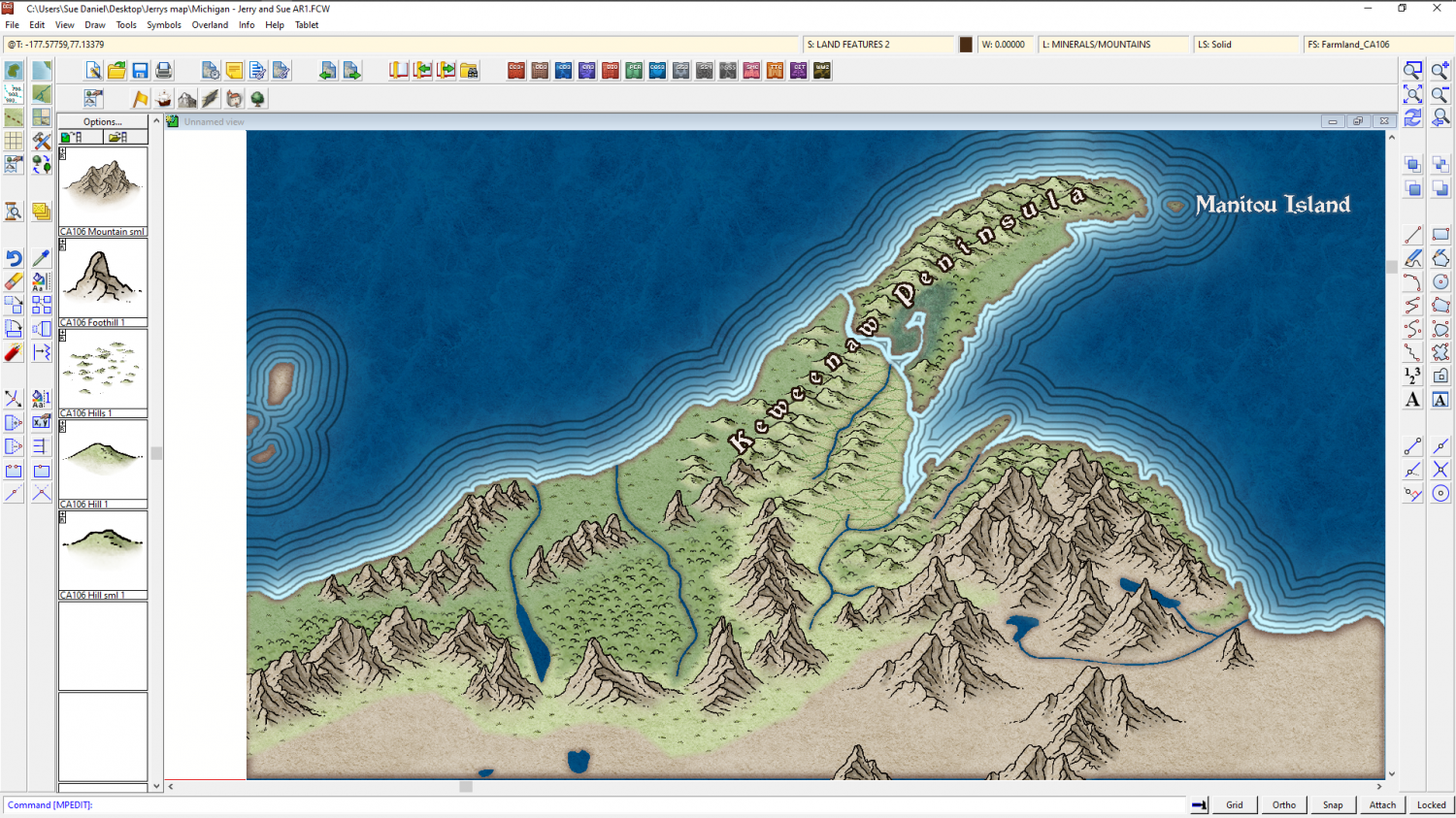
The reason I'm adding the real world names is to give us a reference for further instructions. It's easier if you say change "Fred" to "Burt", than if you give me a lengthy description of where you want a label that doesn't exist yet.


-
The Lakes of Michigami (Jerry's Map) - WIP thread
So this is going to be a historic fantasy of sorts - a mixture of actual history/legend and fantasy?
You may have to be a bit patient with me over what goes where, since I have no familiarity with the area at all. I'm also not good with pages and pages of text. Easily lost, you see. Much better with well-timed short bits of info ;)
Found Grand Traverse and Mission Point. There's not really enough room to add the name of the peninsula as well, but that's probably better done by a smaller regional map when Quenten gets going on them.
-
Live Mapping: Spectrum Overland Expansion
I missed that bit! I must watch it again and see if you're right :)
And thank you :)
-
Tangram Heightmapper
I've no idea if anyone else has already shared a link to this site, but if you are looking for heightmaps to use in Wilbur or FT3 to generate real world relief shade maps this might seem to be a good place.
The only drawback is the Mercator projection, which grossly distorts anything in the extreme north and south.
![[Deleted User]](https://secure.gravatar.com/avatar/c75d9a245b74d9c59be0999ea81ca541/?default=https%3A%2F%2Fvanillicon.com%2F92add7f8c954488718110edc4896ad39_200.png&rating=g&size=200)

-
The Lakes of Michigami (Jerry's Map) - WIP thread
Hi Everyone :)
This is a WIP thread showing the completion of a map that was started a while back by Jerry Thiel. Jerry has done a vast amount of work for the Community Atlas, but sadly owing to Motor Neurone Disease is no longer able to map. I offered to finish a map of his choice for him, and Jerry sent me the FCW for a map based on the Michigan area south of the Great Lakes where he grew up. I also asked if Jerry wanted this to be a private thing, or if he wished me to do a WIP thread. Jerry chose the WIP thread option, so here we go...
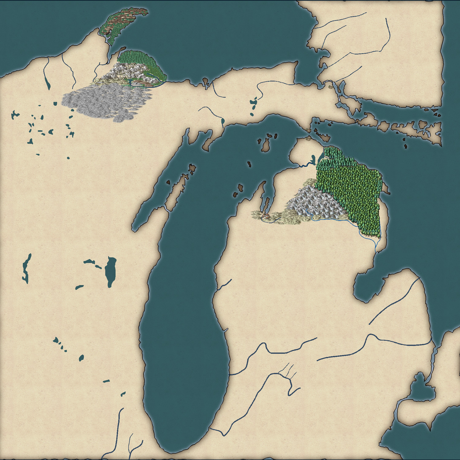
The map (which I have temporarily named "Jerry's Map") is based on the Michigan area around the Great Lakes of North America.
This is what Jerry had to say about the continuation of his map:
"Use any style you want. I was planning on a fantasy world. The big village would have been called "City of the Grand Traverse." The early French explorers called the passage across the large bay from the peninsula tip east, the Grand Traverse, as it shortened their canoe voyage significantly.
The two villages facing each other on the Upper and Lower Peninsulas I pictured as the capitols of two antagonistic city-states.
The narrow peninsula running north from GT Is called Old Mission Peninsula after a small mission church built to service the local Indian reservation. The northern tip of the on the 45 latitude and there is an Indian legend that warriors would gather there on the summer solstice to shoot at the sun to cause it to turn back to the south so that it couldn't escape to leave the world in eternal darkness."
Jerry - please feel free to comment and guide as we go. It is, after all, your map I'm working on :)


