


Loopysue
Loopysue
About
- Username
- Loopysue
- Joined
- Visits
- 9,987
- Last Active
- Roles
- Member, ProFantasy
- Points
- 9,864
- Birthday
- June 29, 1966
- Location
- Dorset, England, UK
- Real Name
- Sue Daniel (aka 'Mouse')
- Rank
- Cartographer
- Badges
- 27
Latest Images


-
Ayreon
I think its looking quite good so far.
You can make the joins between different bits of terrain more natural by increasing the width of the Edge Fade Inner sheet effect that should be present on those sheets.
Don't forget that it won't work between two different terrains if they are on the same sheet as each other.

-
Marine Dungeon - a Cartographer's Annual development thread
It's a pity you can't do it the way I do it in dreams. The water exists as air. The only way I can tell I'm underwater is the light, the ripples in the sky, and the creatures swimming past. Think Mars gravity, thick air you can fly through if you flap your arms, coral and kelp instead of grass and trees, and 'flocks' of fish flying past instead of birds.


-
Ayreon
It looks like an artefact that can happen sometimes if there are 2 nodes very close together. It will probably appear and disappear as you zoom in and out.
The solution is to use the SIMPLIFY command to remove these problematic nodes.
Type SIMPLIFY on your keyboard and hit Enter. Look at the command prompt and see the distance set by default. You can enter a new value, or just hit Return again to use that one. Then use the tool to simplify the coastline of the island the line is coming from.
If you lose too much detail just hit the undo (CTRL+Z) and reduce the factor and try again.

-
Where is there a tutorial on how to change the sizes?
I would recommend leaving the drawing units well alone.
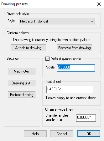
The symbol size that Quenten and Jim were referring to is this one - the Default Symbol scale highlighted below. Changing it will change the size of all the symbols from that point on, but will do nothing to symbols already placed in the map.
However...
Since you are saying that everything is too large is it possible that the map itself is too small?
-
Dorchester - A John Speed city
Following Ralf's most recent Live Mapping Session demonstrating the use of the his John Speed City style, published in the first Cartographer's Annual, I did this map this evening.
John Speed had actually done a map of this town - my county town, so I used that as a reference for the approximate shape and form of my own map.
This is the first map I've ever done in this style, and I enjoyed it enormously.
I hope you don't mind, Ralf, but I decided to add a parchment texture overlay...


![[Deleted User]](https://secure.gravatar.com/avatar/c75d9a245b74d9c59be0999ea81ca541/?default=https%3A%2F%2Fvanillicon.com%2F92add7f8c954488718110edc4896ad39_200.png&rating=g&size=200)


 and 6 others.
