


Loopysue
Loopysue
About
- Username
- Loopysue
- Joined
- Visits
- 10,018
- Last Active
- Roles
- Member, ProFantasy
- Points
- 9,874
- Birthday
- June 29, 1966
- Location
- Dorset, England, UK
- Real Name
- Sue Daniel (aka 'Mouse')
- Rank
- Cartographer
- Badges
- 27
Latest Images


-
Creepy crypts
I'm guessing that's the part where you draw the hole rather than the wall around it? The way it's set up all the sheet effects are tuned specifically to that method. You could change it, but that would involve changing all the sheet effects as well if you stayed with the Creepy Crypts template.
Alternatively, you could start a DD3 map and import the fills and symbols from Creepy Crypts if you want a more standard technique. The way you do that is to pretend to import the existing Creepy Crypts map into the new DD3 map but press ESC before you paste it. That will give you all the fills. Then to get the symbols you will need to open the Creepy Crypts symbol catalogues instead of the DD3 ones.

-
[WIP] First Cosmographer Map - Space Elevator Cabin
Might the seats be recliner versions in the Economy Class compartment?
-
Map Size - ReSize
That's a different thing again.
The size of your map in CC3 doesn't really matter. It's the size you export it as an image.
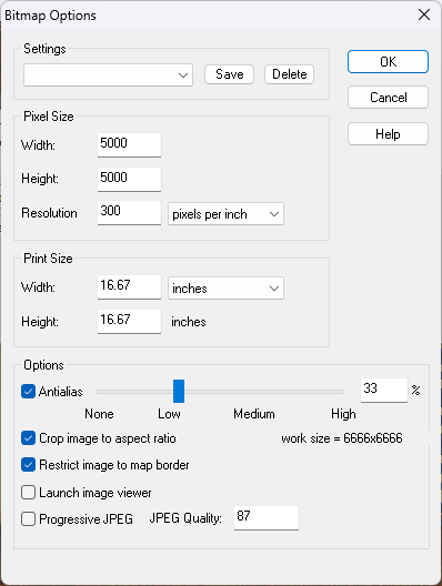
When you pick Save as... from the File menu the Save as... dialog box has a drop down box where you can pick the kind of file. Pick one of the rectangular section images. JPEG is better for VTT because PNG are a bit large. Once you've picked your Rectangular section JPEG click the Options button. That will bring up this box.
These just happen to be my settings as they are this moment in time. They probably won't be what you need unless there is a huge coincidence. So work out how big you want your exported image (adjusting any of the settings will affect the others accordingly), and ok them. Then export your map. A rectangular section export requires you to click both the opposite corners of the rectangle you want to export.

-
Map Size - ReSize
Hi Gulwolf :)
Resize is different to scale because it works by leaving most things as they are but extending the background, map border, screen and any frame the map might have. This is to increase the space available to draw extra bits onto the edges of the map, while scale just makes the whole map bigger, including all the symbols and fills.
If you were trying to get some more space to continue the map beyond the current edges and your 'sea level' was supposed to be stretched like the background was, reverse the resize operation by doing it again but putting the old size back in, then move your sea level to the BACKGROUND layer using Change Properties. (That's the layer, not the sheet. It can stay on whatever sheet it is on.) The Resize operation should then work as before but this time include the sea level information.
-
Symbol Scale Issue
Without knowing how you have imported the new symbols it's a bit difficult to say.
When you say imported them, how do you mean? Did you use the Symbol Manager or some other means?

