


Loopysue
Loopysue
About
- Username
- Loopysue
- Joined
- Visits
- 9,967
- Last Active
- Roles
- Member, ProFantasy
- Points
- 9,852
- Birthday
- June 29, 1966
- Location
- Dorset, England, UK
- Real Name
- Sue Daniel (aka 'Mouse')
- Rank
- Cartographer
- Badges
- 27
Latest Images


-
Creating large cities without crashing
Using Count All in the Info menu, you can see there are over 100,000 entities in this drawing. That is because most of the buildings are House entities laid down in Streets. That's fine, but you can expect things to be a little slow.
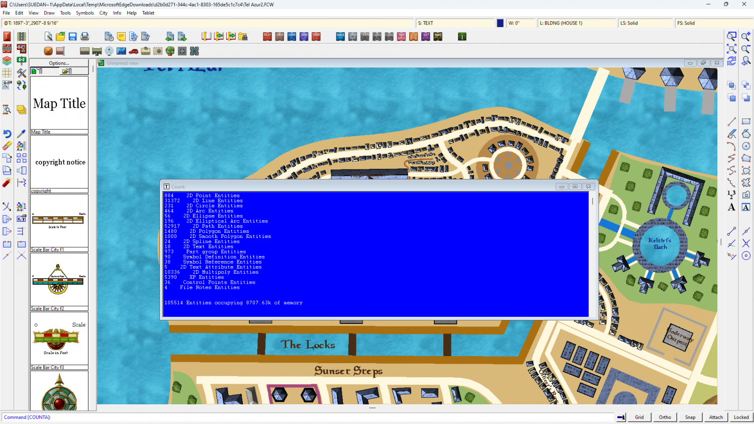
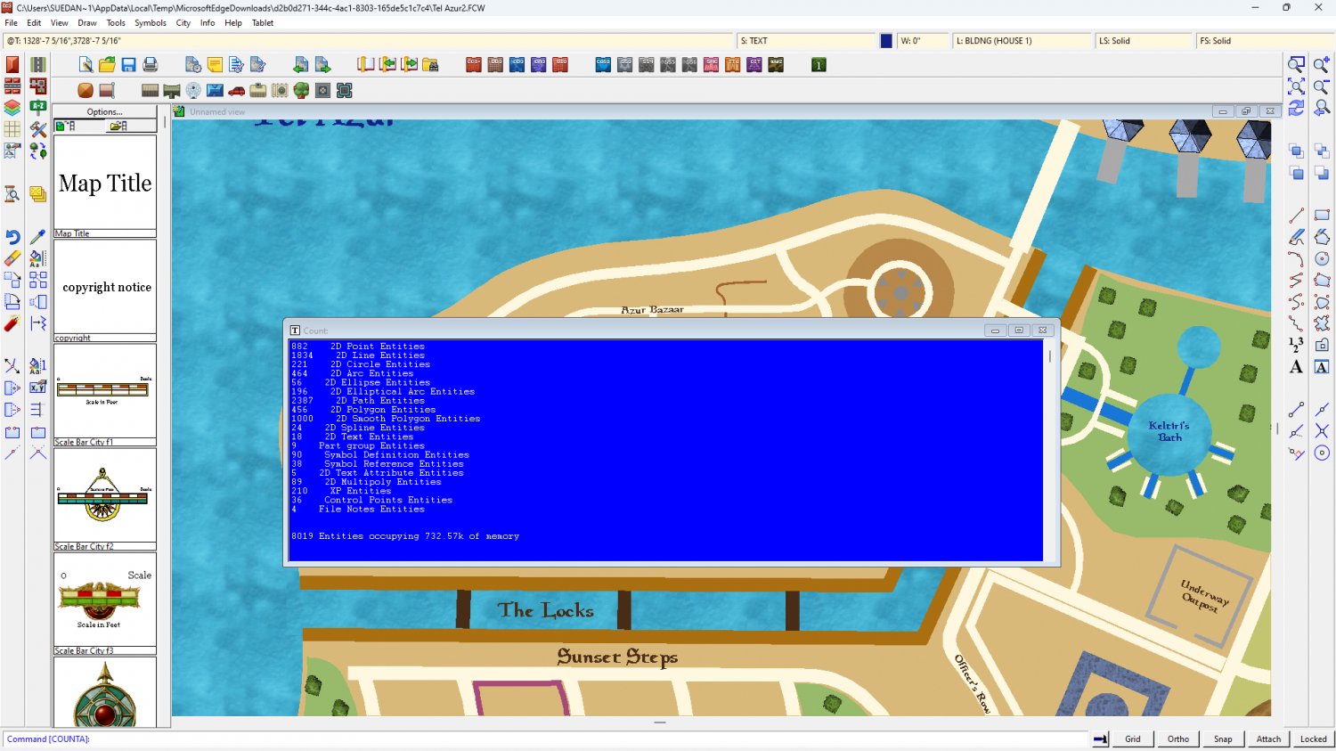
If you hide the buildings there are only just over 8,000 entities - less than 1/10 of the total. The map also zooms and pans much faster.
So putting different districts on different layers as described in detail by Quenten above, you should find it a lot more maneagable.
I didn't have any trouble with CC crashing. Did you mean crashing to desktop, or just giving you a green screen within the map window? The green screen shows when CC uses all the available memory to calculate the new display, rather than trying to show you all the stages between then and now, and is quite normal on maps with this may entities.

-
Creating large cities without crashing
The two level mapping is probably the best idea.
You can (if you don't find it too awkward constantly hiding and showing different layers) do largish cities in one map by putting each district on it's own layer and only having the layers you are working on visible.

-
Difference between layers and sheets
I think (though I might be wrong) that when these two were named it might have been before 'layers' were commonly accepted as the industry standard as the things you draw on in bitmap apps. But I also get confused at times by the now non-standard names for things that we all used in the early days of computer graphics. I use bitmap apps more frequently than CC these days because I generate CC assets using Affinity, GIMP, Krita... etc, so it was several years before I stopped accidentally calling sheets layers, and layers sheets, back in the days when I was helping new mappers on a range of different mapping apps over at Cartographer's Guild.
However, that's a great explanation from Joseph Slayton about how it all works in CC.
These are the layers most commonly kept frozen so the entities on them don't get moved or deleted by mistake:
- MAP BORDER - should only have a rectangle or 4 defining lines (usually in bright green) that tell CC where the edge of the map is.
- SCREEN - Holds the white collar around the outside of the map to cover up bits of symbols and fills that don't lie within the map border.
- BACKGROUND - not always frozen, but I prefer it that way so I don't keep picking the edges or corners when mapping.
Layers that you shouldn't manually mess with:
- MERGE - is used by CC, and causes some really weird stuff to happen if it's hidden, or things end up on it by mistake.
- SYMBOL DEFINITION - I wouldn't know how to technically describe it, but this layer has something to do with logging or controlling what symbols are in the map.
Example maps usually have all the layers frozen so they can't be accidentally altered, but if you want to make a copy and unfreeze the layers to create your own version for a game, that's easy enough to do.


-
How do I fix the lines on my map?
Hi Otaku :)
The blue lines are eminating from the objects on the CONTOURS (LAND) sheet because the line width there is greater than zero.
There are duplicate entities on the LAND sheet, and the COASTLINE entities aren't behaving properly at all, I recommend working with just the CONTOURS (LAND) sheet entities and deleting the entities on the LAND and COASTLINE sheets. I've written a more detailed suggestion below.
Please work on a copy of your original map in case anything goes wrong, or in case I've completely forgotten to tell you about something.
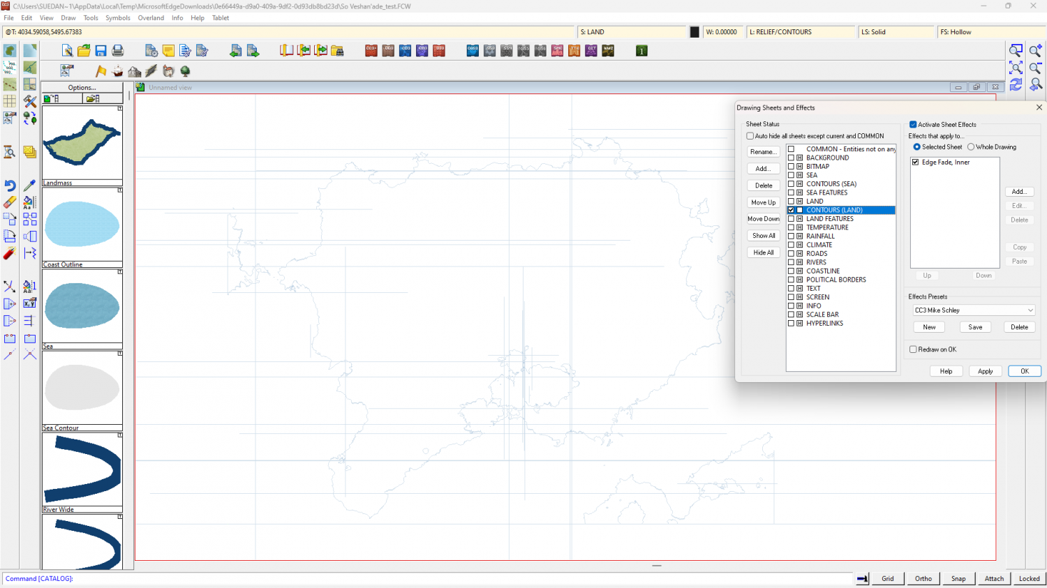
Step 1 - The first thing to do is isolate and delete all the duplicated entities on the LAND and COASTLINE sheets by hiding all the other sheets. Then reshow just the CONTOURS (LAND) sheet.
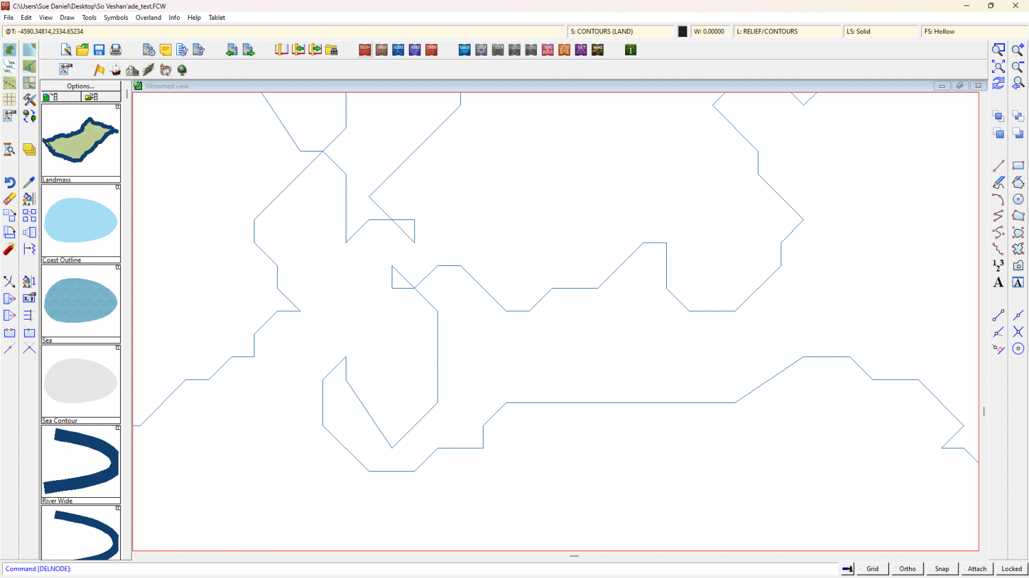
Step 2 - Switch off the sheet effects (uncheck the Activate Sheet Effects checkbox at the top right of the dialog). Make sure that only the CONTOURS (LAND) sheet is visible. Ok the Sheets and Effects dialog and use the Change Properties tool |CC2MCHANGE|to set the line width to zero for all the visible entities. This should get rid of those grid lines. At this stage you can then use SIMPLIFY on the visible entities if you wish. I found that the shapes were already quite simple and didn't look any more simple until I used a distance factor over 1 (I used 2).
Step 3 - Whether or not you use SIMPLIFY, the polygons on this sheet have artefacts you probably don't want to keep, such as these single lines - 2 node polygon islands and peninsulars. You can use the delete node tool |CC2DELNODE|to get rid of them.

Step 4 - Once you have tidied up all the undesirable bits use the Change Properties tool again |CC2MCHANGE| to set the Fill style (choose the land fill), and the Sheet (LAND), and hit OK.
Step 5 - show all the sheets again and turn the sheet effects back on.
Notes...
There are other ways of doing the same thing, but this one worked best for me in this situation.
The reason I haven't recommended recreating the COASTLINE polygons (the blue line around the edge) is because the staggered nature of the coast does not lend itself well to that method of delineating the land. Any increase in line width, which is what the coastline is - a line with a width, will most likely cause the grid to reappear. If you want to have a blue line around the land as if there is still a coastline present, you can use sheet effects on the LAND sheet to simulate one without that grid problem. If you are unsure of how to do that shout again. Either I or another member will help you.
-
can't resize map borders
Thanks.
I've put the black rectangle on the SCREEN layer, so it should resize with the rest of the map.
The Resize map note might also have been giving you some problems, since the contents were "SCALE", instead of "STRETCH". When scale is used you can only scale the size up or down and are forced to keep the same proportions. I've edited it to STRETCH, so you can have it any size or proportion you want.
As a general rule, the only things that respond to the Resize operation are entities on the BACKGROUND, MAP BORDER and SCREEN layers. That's layers, not sheets. So if you end up with a problem where something that really should be stretched doesn't respond properly, make sure it's on either the BACKGROUND or SCREEN layers. Having extra stuff on the MAP BORDER layer is problematic.
I hope that helps.

