


Loopysue
Loopysue
About
- Username
- Loopysue
- Joined
- Visits
- 9,967
- Last Active
- Roles
- Member, ProFantasy
- Points
- 9,852
- Birthday
- June 29, 1966
- Location
- Dorset, England, UK
- Real Name
- Sue Daniel (aka 'Mouse')
- Rank
- Cartographer
- Badges
- 27
Latest Images


-
Fractal Terrain 3 beginner
Ok. It looks like you've been having some fun with the World Settings.
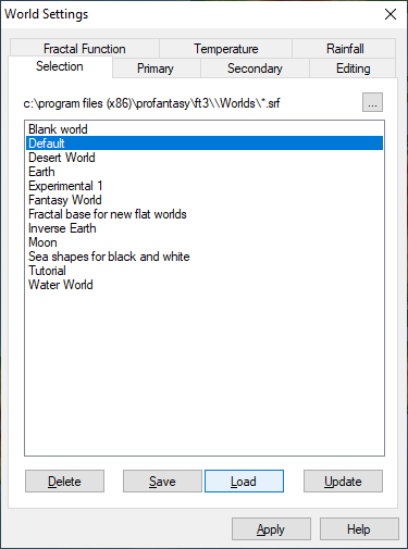
Open the World settings and the Selection tab. Pick the Default, and click Load, then Apply. You should see the default world appear right before your eyes.
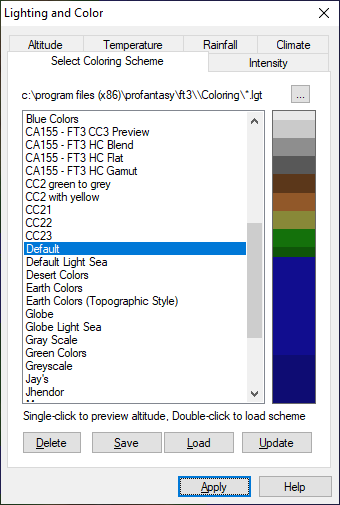
Altitude colours can be similarly set back to default by opening the Lighting and Colour dialog and doing the same thing there. (You won't necessarily have all the same settings as me in either of these dialogs, since many of these are my own home-made settings, but you will always have the defaults and the standard alternative settings)
Remember that in both cases you must first click Load, before you hit Apply.
If you want to change the way things are I recommend playing with only one thing at once on the World Settings Primary tab and clicking Apply each time you change something. That way you will get used to the feel of what everything does.
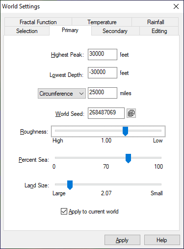
Then if you get into a tangle with it again you know how to get back to where you were.
Once you have the settings just right I would save them, but to do that you must have opened FT3 by right clicking the icon and picking Run as administrator, or you won't have authorisation to save the new settings.


-
WIP Commission, Ancient Tombs
Fields can be a bit difficult to get right. This surprises a lot of people, but it's true.
Here are a few thoughts on the shape they take:
- In a medieval field system there were quite often major and minor divisions in the UK. One large field area marked by a hedge or stone wall, with strip fields that were the responsibility of different tenants, and from which the stones were cleared to either side, causing ridges to build up between the strips - strip lynchets.
- Fields tended to follow the contours around hills, and align themselves with a narrow end to the river, so that even if their boundaries were straight the grid they formed warped around these features.
- Even in extremely flat areas the presence of a river or a road will disrupt the gird.
- Not many places on Earth show boundaries that are exactly East-West or North-South. The grid, if there is one, can be aligned in any direction depending on which direction allows for the most convenient layout, or the greatest area put to the plough.
These are only general rules of thumb. I'm quite sure these things are totally contradicted in many places that aren't England, but they hold true right here where I live.


![[Deleted User]](https://secure.gravatar.com/avatar/c75d9a245b74d9c59be0999ea81ca541/?default=https%3A%2F%2Fvanillicon.com%2F92add7f8c954488718110edc4896ad39_200.png&rating=g&size=200)


-
Q on Copywrite & Licence
What Simon Rogers says on this thread is key to your request about the tokens in particular. Simon is our Managing Director, so whatever he says on the matter is the final word.
Using DD/CC symbols in Roll20 as tokens instead of map symbols — ProFantasy Community Forum

-
Why won't the houses change color?
No it's not a bug. Whether you can change the colour of a house or not depends on what kind of house it is. If you do it to one that has been placed as a varicolour symbol it will work. If not, it won't.

-
Question re scale.
I think you mean map units, not scale. All city maps are the same scale - which happens to be the same scale as a dungeon map - 1 foot to one map unit.
As to the correct size, you will probably be a week or so discussing that one with everyone else, because the size of a city is only party dictated by the size of the population. If space is cramped cities are also cramped and tend to have more taller buildings than a city with the same population built in the middle of a vast plain. There are also cultural issues to consider. What is the accepted maximum number of families per household. In the UK just a couple of hundred years ago at the dawn of the Industrial age it was quite normal for 2-3 entire families to live in a single room of a multi-level building where they had come in from the country to find work in the new factories. These days people would gasp in horror at the very idea of it. We live very insular lives, and there are many who live as single adults with a whole flat to themselves.
There are many other considerations, but you get the idea. It's very much up to you how big you make the city, but useful to count each building by how many people you would expect to be living in it.

