


Wyvern
Wyvern
About
- Username
- Wyvern
- Joined
- Visits
- 3,240
- Last Active
- Roles
- Member
- Points
- 5,521
- Rank
- Cartographer
- Badges
- 24
Latest Images


-
Community Atlas: Errynor Map 33 - Siolforland
While the choice and location for most of the map's non-landscape features were decided randomly, as done, and discussed, for previous of these Errynor maps, this time not all the settlements were, as just over half the smaller ones were added subsequently, chiefly along the main river lines in the lower half of the area:
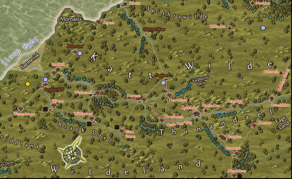
Those that were located randomly had helped determine the general layout for the river lines, in combination with the more obvious geographic requirements. After the resources were added, again randomly, the curious concentration of several coal markers near these established waterways helped provide the spark for what became the civilisation hereabouts, as portrayed in the map's PDF file. Adding the "missing" coal mining villages deliberately to complete the pattern, led naturally to providing mining settlements near the mercury deposits that didn't already have one, plus of course there would be further smaller places, down to individual farmsteads, were this map not at the "large-regional" scale it is.
Route junctions, bridging points, minor landscape features and nearby creatures then helped generate ideas for the varying local character of particular settlements, with names then either chosen to suit those, or sometimes where the names helped give an extra concept of what might be happening at certain places, beyond anything obvious from their physical siting.
Having done that on land, a couple of smaller settlements were added undersea as well to round things off more, along with one last non-random settlement on Hwael Igland ("Whale Island"), since this little island took on an increasingly important role during the development of ideas regarding the ocean trade-route to Arkant from here. However, Hwael Igland is the subject of another Atlas map, so that's a story for another time!


![[Deleted User]](https://secure.gravatar.com/avatar/c75d9a245b74d9c59be0999ea81ca541/?default=https%3A%2F%2Fvanillicon.com%2F92add7f8c954488718110edc4896ad39_200.png&rating=g&size=200)


-
SS6 - free imperial grid
Yes please, another vote in favour of having the grids as options in the final SS6 - imperial and metric!


-
And like a bad penny, I keep showing back up!
Oh yeah, 'cos finding and installing the programs again - and the Update last of all (don't forget the Update!!!) - is only the START of the process...💻️🖱️😡🤬😵🔨🗺️😁

-
Stop teasing us Ralf !! :)
Yes, I can confirm the e-mail reached me too, timed at 19:57 UTC on November 19. Unless that was sent as a separate, second tranche of messages because of the comments here (and I imagine more directly too), it still seems like something worth investigating to see what went wrong, so it (hopefully - computers & Internet, after all...) doesn't happen again. Well, not till next time anyway 😉
-
Stop teasing us Ralf !! :)
Yeah, I have my spam folder on automatic view all the time, so it's definitely not appeared here still.
Regardless of any individual requests, this is clearly something rather more major concerning the Newsletter. It's fine for folks in the know who visit the Forum regularly to work out what's happening, but there must be many more who don't - if a Newsletter doesn't arrive, how'd they know?
