


Wyvern
Wyvern
About
- Username
- Wyvern
- Joined
- Visits
- 3,240
- Last Active
- Roles
- Member
- Points
- 5,521
- Rank
- Cartographer
- Badges
- 24
Latest Images


-
Hexroll, an online random hexcrawl sandbox generator
A quick run through of the YouTube videos for this (they're all VERY short!) suggests the idea is to use whatever's generated with a tablet to actually run games. There are plans to make the dungeon maps SVG format too and to add fog-of-war options for showing/hiding areas.
Perhaps of greatest interest is that the hexmaps are in development for zooming-in to show features like maps of settlements (which are generated by - go on, guess - Watabou!). This should indeed enhance using such a system for online/computer use.

-
Starfinder rpg site, with maps
You might be able to use resized pieces of Cosmographer starship gear for the space-stations Jim, if they'll stand resizing sufficiently. At this scale, something that obviously isn't the shape of a planet will probably work!
Also, is it "Disapora"? I don't know Starfinder, but for a scatter of asteroids (which is what this seems to be), "Diaspora" might be more apt.

-
Hexcrawling starter maps
Thanks @jmabbott !
I tried playing around with some of the CA97 B&W drawing tools, fills and symbols, which is what made me realise that if only the resolution of some of the original images for the fills and symbols had been a lot better, it would have solved many of the current issues. Of course, whether the original drawings were of any higher res, I don't know. The style's about eight years old, so maybe we could suggest a makeover for it as a few others have had lately, especially given the current popularity of OSR systems overall. [Is that too subtle a hint? 😁]
It's interesting that hex maps never really caught on for dungeoneering. I recall one of my early close-acquaintance DMs used a clear plastic covered hex map and erasable marker pens to draw out key settings on the fly, but that was pretty much of a rarity (this was back in the very early 1980s). I think they have continued to appear from time to time, though quite rarely. Of course, as your drawing neatly illustrates, hexes do create the fresh problem of partial hexes - there's just no winning whatever we try 😉!
Although the ShadowDark dungeon maps use squares on the solid floors (only), which gives a sense of scale to the drawing and in use, the rules are deliberately very free-form-vague about distances overall, with just Close = 5 feet, Near = up to 30 feet and Far = within sight, which (finally!) pulls the game further away from its wargaming roots, of sometimes ridiculously precise needs for measurement on the tabletop.

-
Hexcrawling starter maps
The published maps and artwork for ShadowDark all tends to be black-and-white. I don't mean greyscale here, but sharply-contrasting black-and-white line hand-drawings. It would be good to have something similar for CC3+ (especially for dungeon-style maps, as the current CC black-and-white dungeon styles don't have sufficient bitmap options, or high enough symbol and bitmap resolutions, to look sufficiently clear and presentable - I did some tests for this too), particularly given the current popularity of OSR systems overall, which tend to favour this kind of map look in general. It is though easy enough to convert these maps to at least greyscale, simply by adding a suitable RGB Matrix Process effect to the whole map:
Oh, and a minor tweak to the colour of the lettering!


-
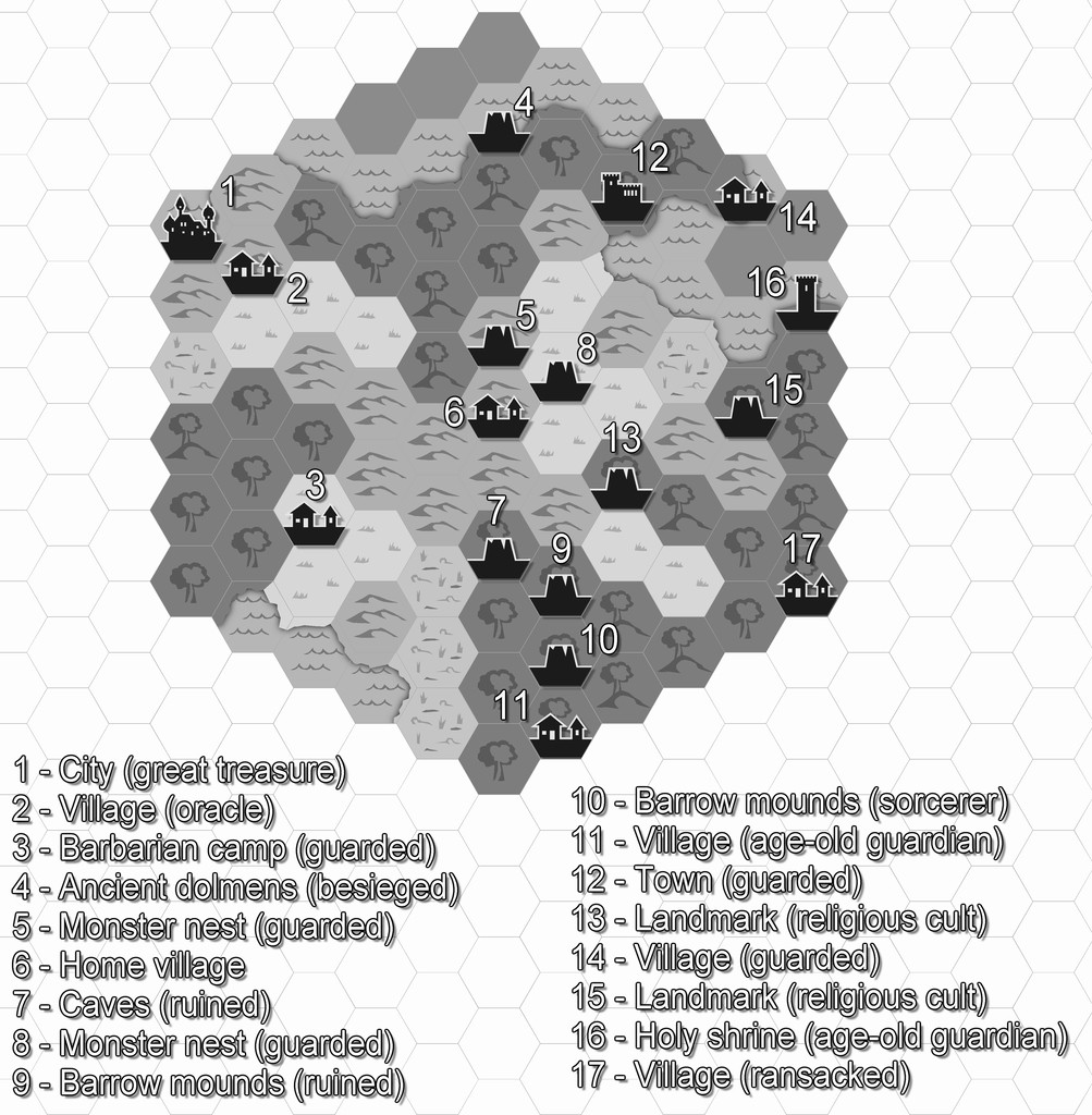
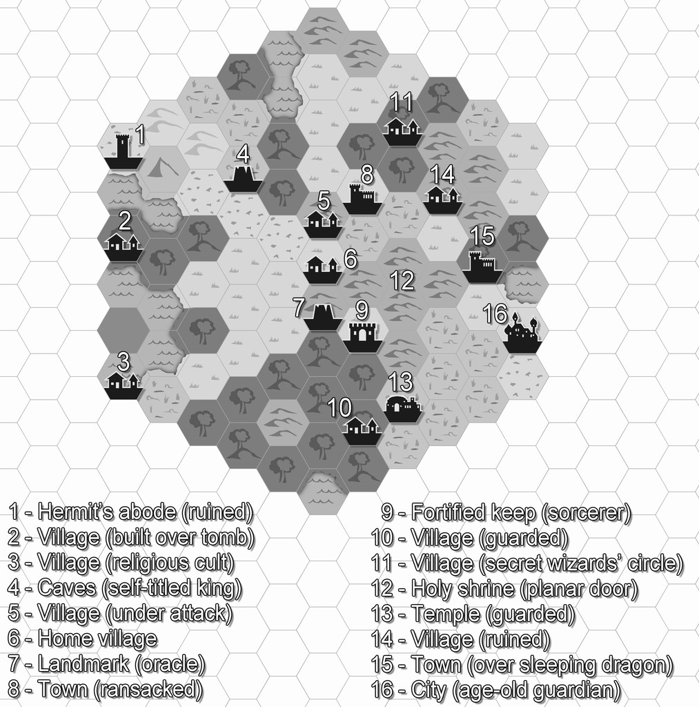
Hexcrawling starter maps
There's an obvious couple of problems here. One is there isn't a great enough diversity of symbols to cover even the fairly small range of non-settlement features that might be useful, and which only an expansion of the style (either by PF or personally) would solve. [There is a further issue here too, in that none of the location symbols actually work to the standard snap grids used in this Annual. I'm not sure if that may have been amended since I downloaded my copy, however. I ended up having to place most by eye alone, certainly.]
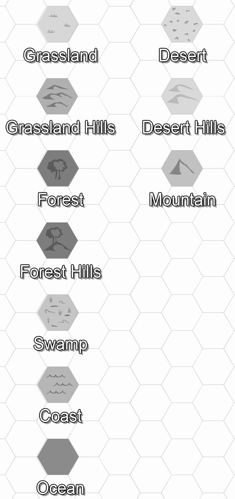
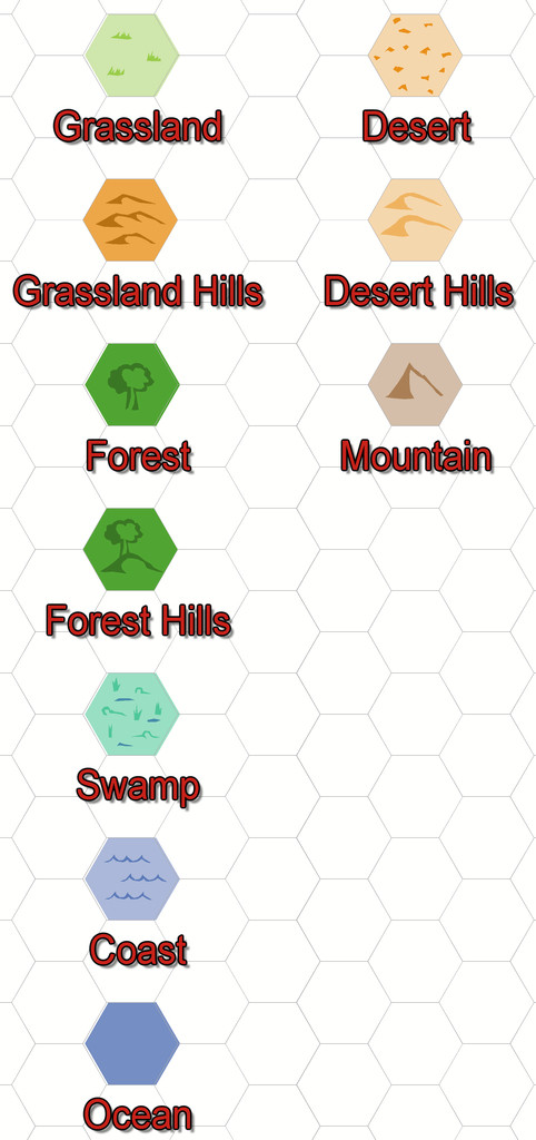
The other is that anything placed in a coastal hex looks as if it's really in the sea, because that's just how hex maps of this sort work. That though is something I could resolve. Plus as I'd been randomly rolling terrain up, I'd noticed there was no "Hills" option in the current ShadowDark tables, so decided to tweak that a little to include some.
So the maps, and additional keyed terrains, came to look like this:
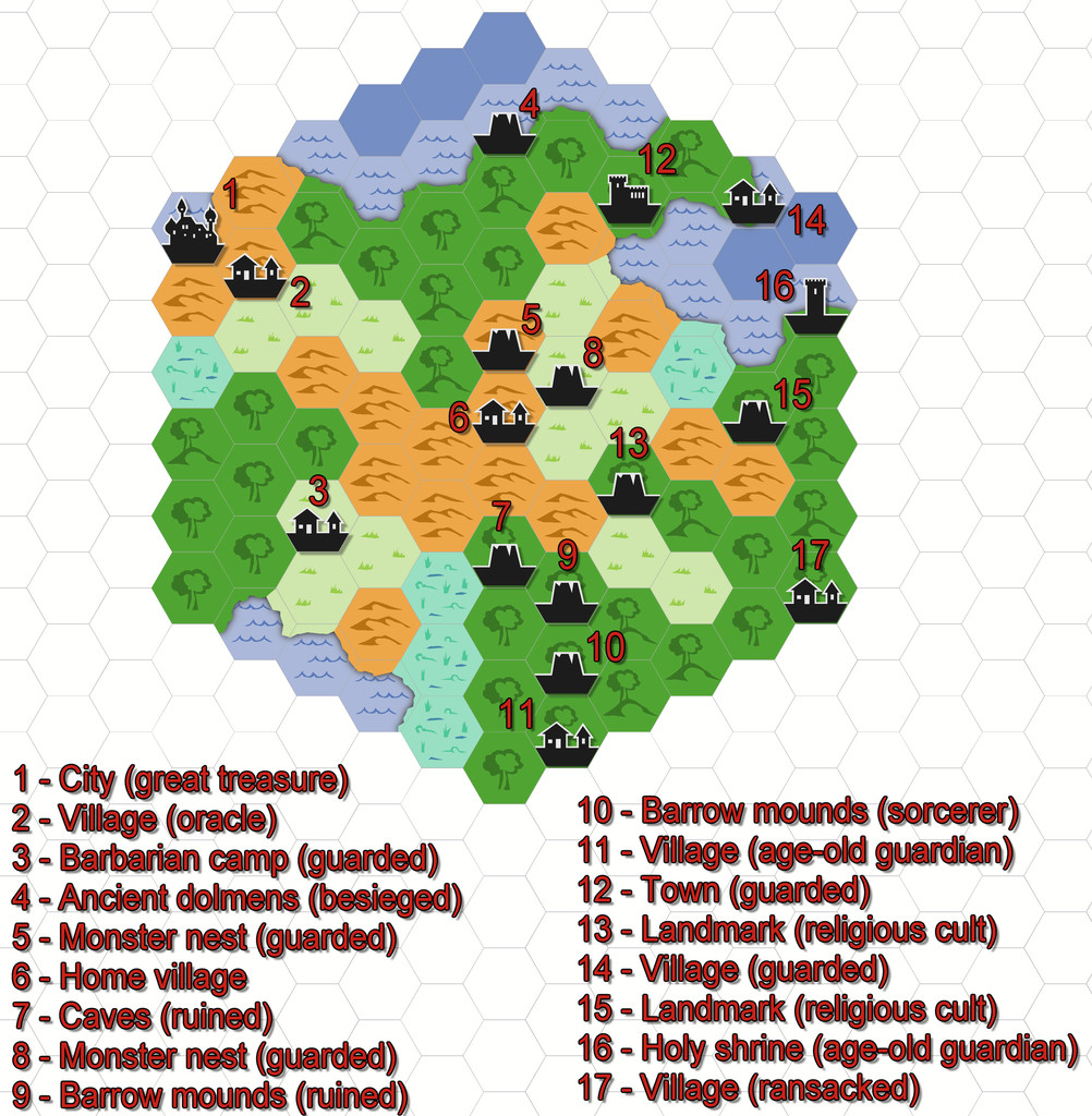
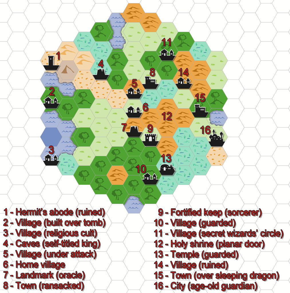
All I did for the coasts was add a small section of land from each adjacent hex over the coastal sea.
