


Wyvern
Wyvern
About
- Username
- Wyvern
- Joined
- Visits
- 3,240
- Last Active
- Roles
- Member
- Points
- 5,519
- Rank
- Cartographer
- Badges
- 24
Latest Images


-
Community Atlas: Dendorlig Hall - A Sort-Of D23 Dungeon for Nibirum
Thanks very much Sue! It took a bit longer than I'd hoped, but reality's kept intruding all year, as it does... However, it was finished well within the year, so as a sort-of D23 effort, that's been quite pleasing.
And many thanks to Remy for getting this into the Atlas so swiftly, of course!


-
Community Atlas: Dendorlig Hall - A Sort-Of D23 Dungeon for Nibirum
So, as promised, the final submission version of the map is now completed, as of Day 280 of 2023 (i.e. yesterday!). And here it is:
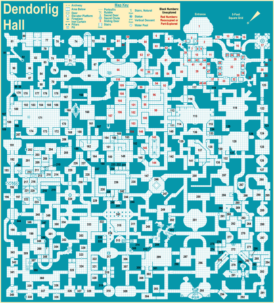
You may not notice any difference from the Day 250 version posted last time, and I'm not sure there actually is one, at least not that would be obvious at this resolution. However, behind the scenes there have been substantial changes, as following discussions with Remy ahead of submitting the map for the Atlas, I've added descriptions as CC3+ map notes for each individual area, as hotspots tied to each number on the map, and which will thus be available in the FCW version of the Atlas map. The complete set of texts for all these, and the general map notes, will also be provided as a single PDF file, as normal.
This particular mapping style is very straightforward to use, and as noted earlier, is also a very forgiving one, which uses no sheet effects. Thus it wasn't a strong challenge to map with, for all that was an interesting experience in itself. However, adding the map notes and hotspots to the map was something I've never tried before, and that proved a useful exercise in expanding my CC3+ experience. It was a great deal more straightforward, and quicker to complete, than I'd anticipated too, which was a pleasant surprise. [This is the point where Remy admonishes me for getting some key part of the exercise wrong, of course...]
I'd never really considered adding notes to my maps electronically, since I normally only use printout versions of them, and while that's unlikely to change, this would be something I'd consider for the Atlas in future now, where the map's suitable for such, having tried it out. Which of course was part of the point in my taking part in mapping for the Atlas, to let me explore elements of the program new to me!
Time to return to my Alarius mapping now though. Although it's possible there might be a further distraction before then...


-
Don't know what projection this is
After a fair bit of digging around online regarding the game this originated with (Living Steel, by Leading Edge Games, from 1987), so far as I can tell, the planet Rhand was intended to be a planet much like Earth - so NOT a cylinder!
The original version of the Rhand map seems to have been done as a fold-out poster for the 1987 boxed set, and was a much simpler-drawn version than this artistic presentation. That map had two separate rectangles (for the east and west "hemispheres", probably centred on the equator, although no latitude lines were shown, only longitudes), and two separate polar circles. This colour-artwork version was included in a later single-volume work called Rhand 2349 in 1991 (see the RPGGeek page for it). You can see both maps together for easy comparison on the Wayne's Books blog posting here by scrolling down to the "Poster Map" section, about halfway down the page.
The map illustrated above seems to have been an attempt to combine these four original planetary sub-maps into one, so as J Slayton already ably noted, it's not any kind of real map projection at all, simply an artistic view of the planet. Sort-of. By the looks, the scale bar was simply copied and pasted from the map on the poster, and should probably be ignored for this map, as it has no actual meaning here.
-
Does CC3+ support webm and webp file types?
Reawakening this topic as over the weekend I discovered a recent change to the basic Windows image viewer software, "Photos", means it will now convert webp images to other forms of image, including various bitmaps, such as jpg. You simply use the "Edit" facility and save it how you require from there. There've been a number of other changes to Photos in recent months, but this one is actually useful 😉!
-
Live Mapping: New City Style Part 4
Not sure if something (else...) has changed about the YouTube interface lately, but this isn't the first stream I've landed on recently where the timing hasn't been what was intended by the creator. In one case, even the DAY was wrong, so at least this was only half an hour out!
