


Wyvern
Wyvern
About
- Username
- Wyvern
- Joined
- Visits
- 3,240
- Last Active
- Roles
- Member
- Points
- 5,519
- Rank
- Cartographer
- Badges
- 24
Latest Images


-
Sinister Sewers - Style Development Thread (CA207)
If the gelatinous cube symbol is actually partly transparent anyway (given you can see the texture of the floor below it), items don't all need adding to the cube. As long as the items exist as symbols, they can simply be put "below" the cube by the map's creator.
On the size element, the "you can drive a cart along them" argument is partly why I suggested seeing the sewers in "The Third Man" movie, because that's where the climactic chase happens, with large numbers of police and soldiers, where there are multiple levels stacked over one another, and nobody has any problems for headroom, and places are up to river-cavern wide in parts. Somewhat like the early London Underground "tubes" (and I'd assume others built around the same time, later 19th century), some of these would have been dug out as trenches, had their surfaces coated with mud/bricks/concrete, etc., and then covered over later where necessary.


-
Sinister Sewers - Style Development Thread (CA207)
I suspect green became the default sewer-water option as an easy way to differentiate it from the blue "ordinary" water which didn't involve anything too "realistic" (given blue as normal water isn't realistic either, of course).
And are we calling these the Sue-ers now 😉😁!


-
Annual 2024?
My email about this arrived around 6½ hours ago now. Resubbed already, naturally!

-
Sinister Sewers - Style Development Thread (CA207)
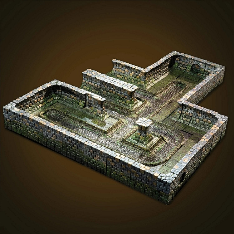
Not a map as such, but the cast terrain company Dwarven Forge do a range of sewer pieces for their "Cities" models, which might provide some pseudo-medieval style inspiration. This link is to their main, fully hand-painted, set, and this is the main image for it:
For ideas on what sewers can sometimes look like, you might care to watch the latter stages of the 1949 movie "The Third Man", or dig through the nearly 100 images relating to it on the IMDb site here, if unfamiliar. Many of the sewer shots were from actual locations under post-war Vienna, although some (notably those with Orson Welles - where you can actually see it's him, as many of his shots were done by a double) were mocked-up/recreated in the studios later.

-
Hotspot not working
Glad we got that sorted at least! I did know about the hotspot disabling, but wasn't online after you replied yesterday. Thankfully, we always have Monsen 😁!

