


Wyvern
Wyvern
About
- Username
- Wyvern
- Joined
- Visits
- 3,240
- Last Active
- Roles
- Member
- Points
- 5,519
- Rank
- Cartographer
- Badges
- 24
Latest Images


-
Community Atlas: Map for the Duin Elisyr area, Doriant
For the upper hex-room cave levels, I hand-sketched some ideas using a mix of graph and tracing paper to make sure I had the general sizes and layouts correct. Then, I redrew those into the CC3+ map, using the same TEMP Sheet and Layer as for the base hex-room layouts earlier. I decided not to scan-in and insert the hand-drawings this time, as I knew things would need adjusting in-map to fit with what was already drawn there.
After that, a great deal of tweaking, changing and moving about followed, to improve the look and layout of the whole. Indeed, this took so long, I didn't have time to start converting the drawn lines to parts of the map, although I did identify one new item, which was the need to indicate a specific hex-room in all the "northern" hex-room cave layouts, to help with orientation (the one larger hex-room on all the "southern" layouts solves that problem there already).
Oh, and I changed all the layout lines to white!
Layout of the upper levels, and what each of these levels will look like, are of course subject to change once converting them to the appearance of the rest of the map begins, and the red-wall room isn't definitely how it will be in the end either. The external exits from some of the higher levels were suggested as existing by the Inkwell Ideas book for these designs, incidentally.
While these were all essential tasks, hopefully, there'll be some "real" mapping progress to report by next time!


-
Community Atlas: Map for the Duin Elisyr area, Doriant
A little further on now, and the cave's starting to look a bit more lived-in:
Getting the effects to look right for the two raised rock platforms in the southern front cave took quite a while, and may need further tweaking. I also tried adding some texturing patches to the cave floors in places, but they started to feel a little too much for the drawing, so were removed after a while. Might have a rethink on those later, perhaps.
I was happier with how the hex-room walls worked out, again after quite a bit of trial and error. Being the basal level here, they're attached directly to the cave floor, and I did add - and left there still - some texture patches inside those rooms. All I did beyond that was move them to a new sheet with some suitable effects, broaden the lines a little and change their colouring. And then cut some narrow doorways using the :CC2BREAK: command. Working on the principle the humanoid bee-folk are slim and not too tall, so they don't really need large doorways!
Upper levels to start after this. More when it's done!

-
Community Atlas: Map for the Duin Elisyr area, Doriant
As the perceptive among you will have noticed, I made a further change to the locations of some of the upper level layout designs after hiding the bitmap sheet I'd been tracing, something that I find happens all the time, when things don't look quite right. And which are liable to be changed repeatedly thereafter till I'm happy (or happier...) with them!
However, to today's update. The exterior is done for now, with ground cover, some vegetation and a few tumbled smaller rocks. I've also added the new SCREEN Sheet mask to hide what's beyond the map border:
The effects on the various external ground and symbols sheets has needed a degree of amending as well to reach this point, and I've also added those three free-standing boulders/rock pillars at the mouth of the southern front cavern. Haven't done anything inside the caves as yet, although I have had to add a small polygon of one of the patchy grey dirt terrain bitmap fills (one of the "T" types) to better disguise one of the outer-inner transitional passageway ends, where (as sometimes happens), the Edge Fade, Inner effect was giving too sharp a line where the outside brown dirt bitmap fill met the grey of the cave floor.
Next will be the initial interior cavern features.
-
Community Atlas: Map for the Duin Elisyr area, Doriant
Thanks very much Sue!
Inkwell indeed have a fascinating collection of RPG-ideas mechanics like the dice and accompanying books, and a range of cards as well, for settings, adventures and characters. In fact, they currently have an active crowdfunding campaign on Backerkit that has only 36 hours left as I type this (ends 2024 May 10, 03:00 GMT) for some new cards.
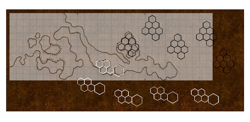
Meanwhile, resuming from where I left off, the first thing I wanted to do was draw the base shapes for those hex-rooms, so they'd be actual hex shapes, not my wonky hand-drawn efforts. This would give a clearer impression of where the four upper level layouts could go, and allow adjusting the position of the inserted base-map, before starting the mapping. So I set-up a suitable 10-foot hex snap-grid:
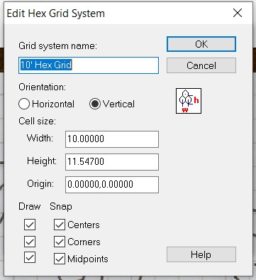
The "Edit Hex Grid System" dialogue pane does pretty much all the work for you, as once you type in the first hex dimension, it automatically calculates the second. For everything else, apart from the grid system's name, I just used the default settings. The resulting maze of dots allows an easy check that the size will work for what's needed. One hex-room is larger though, so I also created a second, 15-foot hex grid similarly.
Then I created a TEMP Sheet and Layer, drew out both the hex-room layouts onto those, using 0.4-width lines, and made four copies of each that could then be moved around to test different layouts. The next illustration shows what I settled on just before beginning the map. In it, the BITMAP sheet now has a 50% transparency effect activated:
The locations for those upper levels are liable to need further adjustment, since I'm likely to want to vary the individual layouts, plus the cave walls will need to be shown too. That will mean more shuffling about, and could require the map border and background to be expanded as well. Neither should be all that difficult, at least in theory...
And so to the basic cave mapping:
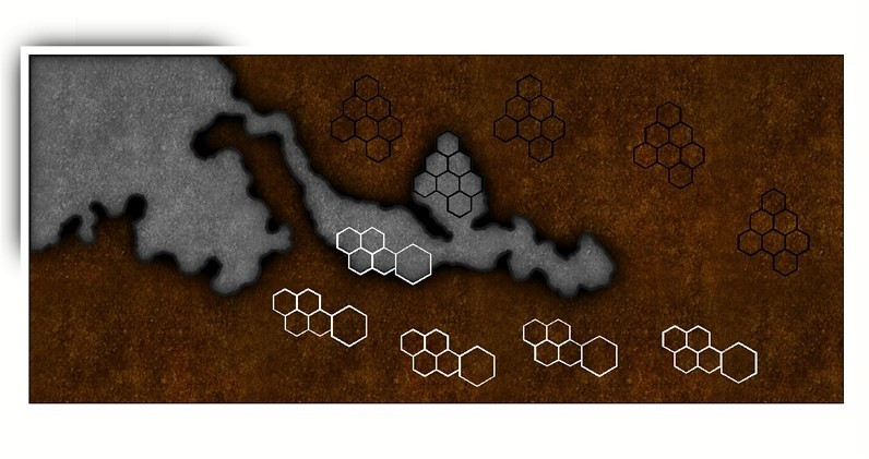
Nothing fancy here as yet, as I've just dropped in a simple hand-copy fractal polygon of the main cave floor and the exterior, using the Cave, Default drawing tool (which also adds walls automatically). Using the drawing tool means it's easy to trace the exact outer lines of those hex-rooms in each respective cavern, although it does mean the cave floor won't be drawn beyond the map border. That creates a couple of problems, as the Outer Glow effect is larger than the current SCREEN sheet's mask (that thin white strip just outside the map's edge) can hide, and there's also a darkening towards the top left map corner due to the Inner Glow on the cave floors.
Enlarging the SCREEN's mask (typing-in the commands "collardel" - which removes the existing Screen Sheet mask - and then "collarauto" - which creates a new, larger, mask on the SCREEN Sheet) is easily done, but I'll wait a while for that, because I also want to draw on some exterior terrain over the cave's base design here, with some vegetation, to make clear it's the outside. Drawing that terrain "floor" so it extends beyond the map's border will also hide the "Inner Glow" issue there currently. That's something for another day though.
-
Community Atlas: Map for the Duin Elisyr area, Doriant
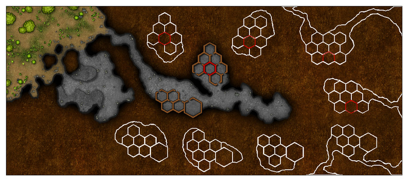
Since the next map in my sort-of Dungeon24 project was scheduled for a new continent for me, and the largest on Nibirum, Doriant, that seemed an opportunity to try to present it as a WIP topic for once. This is something I rarely try, as I usually forget to record what I've been doing as I go along when mapping. So, while making no definite promises, let's give it a try!
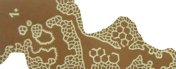
The starting point was, as usual for this part of the project, the base map generated by rolling, in this case three, of the Inkwell Ideas Dungeonmorph dice from the "Delver" set, which produced this layout:
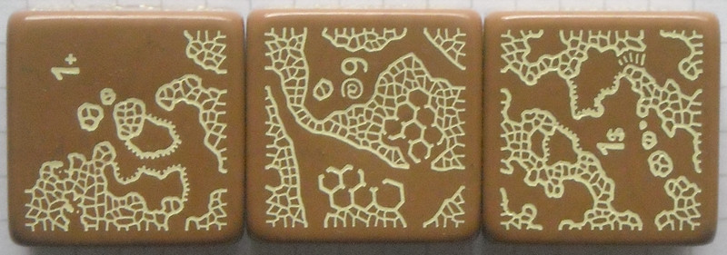
Each die in the Inkwell dice sets has the usual number somewhere on every face, and a unique symbol or letter to show which it is in that set (which is also keyed to descriptions in the accompanying book, for those sets that have them). The symbols have become more complex and non-ASCII as the series has progressed! Here, the "+" die is the one with the entrances, as mentioned last time (see the Petroc Hills topic). Ordinarily, I construct the layout based on the orientation and relative positions of each die as thrown, connecting them to form a pattern. Here though, the entrances die needs to be oriented to fit the rest of the pattern.
Naturally, being geomorphic, there will always be parts of the designs that can't be used, commonly exits that probably won't exist on the final map, or short stretches of dead-end passageways, like that in the lower left of the "1+" die. In this case, a large proportion of the design on the "1$" die and about one-third of that on the "6@" die don't link with the rest. Those might be connected up easily by adding short sections of new tunnel to the linked caves, or they could be left out. As none of these unconnected sections had any of the intriguing hex-rooms, or any other features not present in the rest (except the natural stone steps, which I'd just used in the previous map), I was already thinking to leave them off the final design. What convinced me to do so was checking the text in the accompanying "Dungeonmorph Book of Modular Encounters: Delver, Trailblazer & Voyager Edition", as that suggested using the caves as a bee-folk lair, with the two hex-room caverns as having five vertical levels in each.
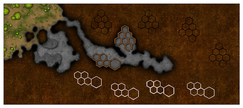
Naturally, those could be done as a set of separate maps, one for each level. Given the relatively small areas though, I thought it would be more interesting to try to present them on a single map, with labels to indicate which level was which instead. That would need space leaving on the base map where those could be drawn, so losing the upper segment from the dice design made sense. Thus we come to something like this:
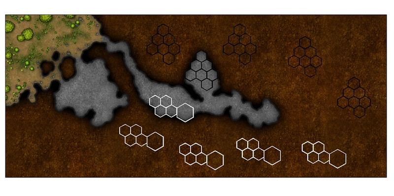
from which a hand-drawn base map can be prepared, smoothing-out the no-longer-exist exits, and fitting the hex-rooms more tightly into that southern cavern especially. As my original hand-drawn version is now so amended and annotated I suspect nobody but me could make sense of it, I've redrafted just the map from it in a clearer form for use here, a scan of which can be inserted later into the CC3+ map for copying:
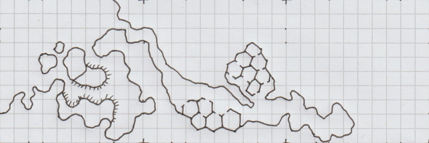
Graph paper makes copying the designs easier, as the dice geomorphs are based on a 10-square layout, with the exits always 3 squares from each die-face corner (hence the layout marks and dots, mostly cropped-off the edges in this diagram). I take each graph-square to be 10 feet per edge, which squares of course make rescaling the image in the CC3+ map much easier too.
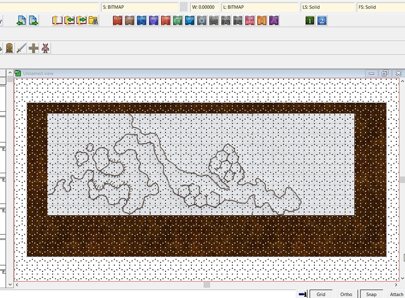
A by-eye estimate, coupled with years of practice, suggested a base-map size of about 350 feet by 150 feet should work OK to start with (it can always be enlarged later, if needs-be), and having decided already to use the basic DD3 style of Caves & Caverns from Cartographer's Annual 7 for the map, I went ahead and created a new map, followed by inserting this base map onto a new BITMAP Sheet and Layer created for the purpose:
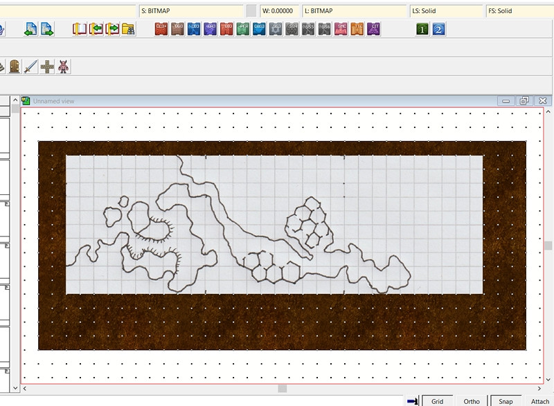
This screenshot shows the 10-foot grid squares, for easy comparison with the graph paper ones. And so it begins...

