


Wyvern
Wyvern
About
- Username
- Wyvern
- Joined
- Visits
- 3,239
- Last Active
- Roles
- Member
- Points
- 5,519
- Rank
- Cartographer
- Badges
- 24
Latest Images


-
isometric throne symbols
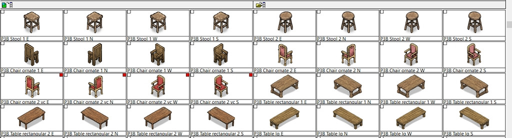
It looks to me as if two of the Throne images have been omitted from the set with Temple of Bones Annual, simply judging from their name-labels and the fact the Chair symbol has all four options correctly.
If that can't be resolved, I found some ornate chairs under the Perspectives 3 Bitmap B options that might work (one is varicolor):
-
[WIP] Sea Elves Outpost
Yep, a mapper after my own heart - wanting to make maps complicated, with many different features that can be accessed only by turning layers on or off 😉😁!
Only point I would make is the undersea plants need direct sunlight (or a magical equivalent) to grow, and many tunnels and rooms seem to be entirely roofed-over. Since the water seems to be shallow enough around the island, you could add giant kelp forests in places there (which could help further disguise the undersea access tunnels), as well as other marine plants to help here. They really needn't be just close to the shoreline, as so long as the water's less than about 200 metres deep, there'll be enough sunlight for photosynthetic growth.

-
WIP Ruins of Charn
One alternative you might try would be not using the RGB Matrix effect, but setting up a simple rectangular polygon that covers all the map on its own, new, sheet, setting the polygon to have a solid red colour, and then adding a Transparency effect to that sheet. If you move the sheet to be below the text, but above the rest of the map sheets, that might work. You'll probably need to keep adjusting the Transparency, and probably also the colour of the polygon (likely somewhere in the reds and oranges range) to get to something you're happy with. Not guaranteed to work ideally, but it should give you more control over the final colour of your text, at least.

-
Hi from Reddog
Selecting can be problematic, especially when you have two things that directly overlap one another. Fortunately, there are a number of different options you can select by using CC3+ to identify which of the objects you've selected you actually want to do something with. This post, the accompanying short linked video, and the linked additional post, again all by Remy Monsen, will help with this, whatever issues you're having with selection.
There isn't a global search mechanic across all the add-ons you may have installed, mostly because it's advisable to choose a style to map in, and stick with that, since those items will usually work well with one another in terms of the overall map appearance. That doesn't stop you from bringing in symbols or bitmap fills from other mapping styles, but you'll need to identify what those are when doing so first of all. If you want to see what symbols and bitmap fills you have on your system, the easiest way is to use Windows' File Explorer, and navigate to wherever you have your CC3+ system installed (the standard default is in ProgramData under Profantasy, for instance).

-
Community Atlas: Map for the Duin Elisyr area, Doriant
So at last, everything's ready, and has now been submitted to the Atlas. This is the final version of the Evth Pass map (higher res version in my Gallery):
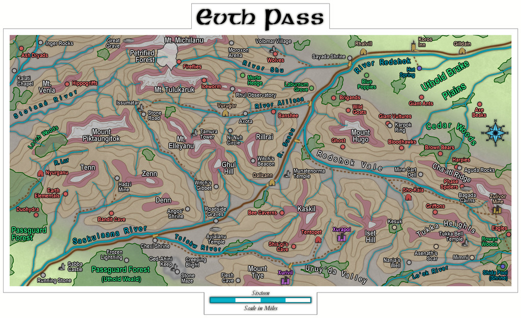
Quite a journey from those three rolled dice that began it all!
Next time, the deities of randomness seem to be dictating a return to Peredur, in its northeastern part, somewhere in the Godtagel area, apparently...


