


Wyvern
Wyvern
About
- Username
- Wyvern
- Joined
- Visits
- 3,238
- Last Active
- Roles
- Member
- Points
- 5,515
- Rank
- Cartographer
- Badges
- 24
Latest Images


-
Community Atlas competition entry: The Summer Palace of the Winter Queen
Thanks very much folks!
Closing-in on the final stages of this project now though, so here's a view of Palace 9:
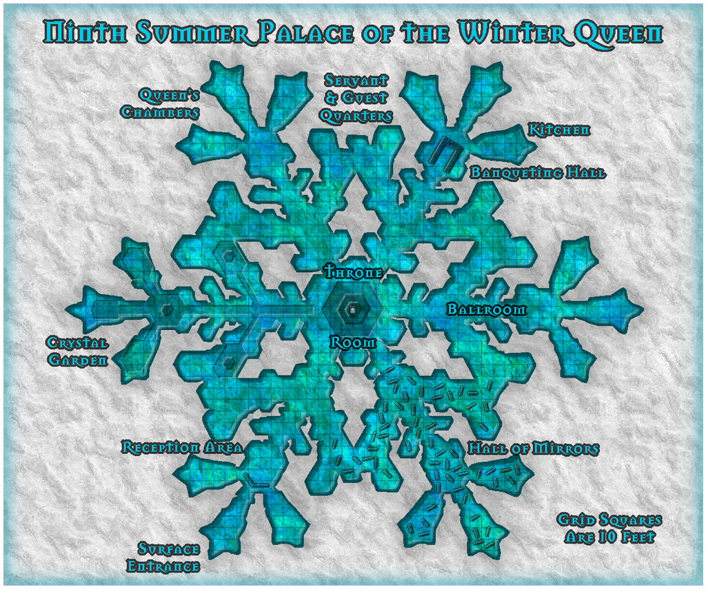
This was done using the SS2 Bitmap A style. I was rather taken with some of the fill options for this, as you might tell! The background here is the snow fill, but the palace itself was drawn using the Water Green 1 fill, as this just seemed such a rich, icy-looking option to give some real colour to this Palace, as a change from some of the previous ones. Not a great many choices from the symbols, unfortunately, as very few come with a varicolor option to better match the icy theme - just the central throne in the end, though at this resolution, you can barely see it, of course.
I'm going to miss drawing these snowflake patterns, I think, but there's the danger that the more I do, the less interesting they may become, since - as my comments regarding the construction of Palace 8 might indicate - I have developed a pattern for drawing these now, which while useful, isn't necessarily such a good thing, as it discourages exploration and innovation. I have enjoyed seeing the styles that were new to me though. There's so much in the full complement of the CC3+ packages I've never properly explored, so I have been trying to take time during this mapping exercise to go through all the fill styles available in each mapping type I've selected, as well as all the symbol catalogues for each. Probably never going to remember where any of these things are when I next need them, but...
Haven't managed to get the rest of the "Palace Quirks" notes typed-up yet; they'll likely follow after the Palace 10 map. And hopefully a little while after that, I might finally get the set submitted for the Atlas!


![[Deleted User]](https://secure.gravatar.com/avatar/c75d9a245b74d9c59be0999ea81ca541/?default=https%3A%2F%2Fvanillicon.com%2F92add7f8c954488718110edc4896ad39_200.png&rating=g&size=200)

-
[WIP] Atlas Competition Entry - Coils of the Cold Coroner
...read the novel?
I picked up the whole Fafhrd & the Mouser series in the Ace editions of 1970 and thereabouts pretty much as soon as I could find a bookshop in the UK that sold them then, as one of the bigger influences on original D&D. Long time since I read them, but I still have the lot! And all the recent talk on the Forum of these stories I read back in this period brings back all the excitement of that first venture into D&D and RPGs more generally (though I didn't know there'd be plurals back in the mid-70s when I started, of course!).

-
Community Atlas competition entry: The Summer Palace of the Winter Queen
Not sure about that, Autumn. I do seem to have got a little carried away with this one though!
-
Grimdark Fantasy (renamed "Darklands") - development thread
I want to say "looking good", but I'm not sure that's an appropriate comment, even if the sentiment's right ?
-
Community Atlas competition entry: The Summer Palace of the Winter Queen
Next, concluding the Palace area notes from the forthcoming PDF description, begun a few days ago.
Crystal Garden: A sunken area, a fountain and pool of running fresh water form the primary physical features in this part of the Palace, all sculpted from ice, with lighting that varies from a sparkling summer daylight quality, as if through moving leaves, to a glowing summer twilight. Places to sit and rest will grow up from the ice for any physical people coming through the Garden. The whole area is particularly peaceful and pleasant, if rather in the fashion of a summer graveyard, complete with passing souls wandering through from time to time. The Garden is filled with an astonishing variety and profusion of delicately-tinted summer ice plants, often with a light hint of summer fragrances on the air. The plants may have herbal properties as reputed to them in lore, or additional, sometimes unexpected, magical ones. Such properties can be used only if gifted freely to someone by the Winter Queen. Taking any without permission renders them instantly ineffective. Such ice plants are also fragile and quite easily damaged; doing so purposefully makes the Queen extremely angry. While she can restore the damage fairly easily in most cases, the offender is liable to be expelled from the Palace instantly, deposited on the surface some considerable distance away, yet still within the Palace's fifty-mile region of influence, so the person can enjoy the worst winter weather the Palace's proximity generates.
Hall of Mirrors: A confusing area set with numerous tall (often ceiling-high) plates of mirror like ice, along with similarly mirrored surfaces on parts of the nearby floor, walls and ceiling. Multiple reflections abound, and it would be very easy to become lost, frightened, or both here, especially as viewing one's own reflection forces the person to revisit their own fears, failings or perceived physical-feature flaws. The longer this goes on, the worse such feelings become. Souls passing through here may be reflected as well, sometimes undergoing a similar process. A few may become trapped within the maze of mirrored reflections and be unable to pass beyond the Palace. Most spirits simply drift through here without problems, however.
Servant & Guest Quarters: Physical creatures requiring regular rest who serve the Queen, and those who become her guests, will be allocated personal spaces in this area, each - should it be necessary - separated from others by freshly-grown, temporary (or occasionally more permanent), ice walls. Even souls that request a secluded spot may be provided with space here. All such can be accommodated comfortably. The area would simply expand outwards should more space be required.
Throne Room: A raised area of variable size with the Queen's throne, often with one or more free-standing walls, dominates this part of the Palace. This is where visitors, whether souls or those physically present, are first brought, if they come to the Palace with a specific need or request for the Winter Queen. Here, she will listen and decide what is to be done. The Queen's Chambers, a private apartment suite where few are ever permitted, either adjoin the Throne Room, or are situated nearby, often with concealed accessways when adjacent to the Throne Room itself.
I decided this wasn't quite enough, because although the ten snowflake Palaces are intended only as examples, each has a character of its own, as well as its variant layout, so I've been adding to a new section for the PDF and text notes as time's allowed, under the heading "Quirks of the Palaces". This adds a few more specific comments for every Palace. As I haven't finished the maps yet, let alone got all these notes typed-up so far, just the quirks for the first five Palaces today.
The First Palace: Probably the most difficult of the ten Palaces to negotiate, with several very narrow passageways, and a number of other places where the walls are rich with sharp, protruding ice crystals liable to snag loose clothing. The floor-to-ceiling freestanding walls in the Reception Area and Servant & Guest Quarters also continue this "narrow way" theme, if in a smoother-surfaced form, with the Reception Area even having its own enclosed chamber in the centre, including a single access point (no doors, of course). The Hall of Mirrors runs between the central nexus and the Banqueting Hall, in the broadest of the six radially-projecting wings of the Palace, liable to be problematic for those other than the Winter Queen going to and from a feast there.
The Second Palace: This has a very large, open, central nexus, in the midst of which is the Hall of Mirrors, surrounded by six broad, floor-to-ceiling freestanding walls that each have a "T"-form in plan, which also serve to divide up the outer part of the nexus into the Palace's six other main areas. Only the Reception Area and Throne Room have freestanding walls beyond this. The substantial one in the Reception Area almost blocks the exit into the Palace proper. The Hall of Mirrors is unusually well-ordered, if as problematic to traverse as normal.
The Third Palace: All parts of this Palace are broad and open, with only the Reception Area having a few freestanding floor-to-ceiling walls to restrict access in a limited way. The large ice-panels separating the central Throne Room from the rest of the complex have mirrored inner surfaces, though they reach only about halfway between floor and ceiling. The central throne on its hexagonal dais can freely rotate to face in any direction. Passage through the Hall of Mirrors is restricted by the numerous, roughly 10 ft tall (3 m) mirror-plates there. Unusually, the Queen's Chambers and Servant & Guest Quarters share the same wing of the Palace.
The Fourth Palace: Freestanding floor-to-ceiling ice walls create narrow ways in various places, including in the Reception Area, Throne Room, central Hall of Mirrors and the Servant & Guest Quarters. The Reception Area has a large, enclosed chamber at its inner end, constructed from some of its extra walls. The Hall of Mirrors, segregated from the rest of the Palace by mirrored walls (the outer ones mirrored only on their inner sides), has smaller ice-mirrors scattered at different angles within it too. None of these latter rise above 10 ft (3 m) tall, however.
The Fifth Palace: Dominated by a large Crystal Garden that occupies the entire central nexus, the ice flowers and foliage here coat the six irregular interior wall-blocks and the surrounding outer walls as well, spilling out, increasingly only as lightly scribed forms further from the Garden, into all the radiating six wings. Freestanding floor-to-ceiling walls are few; one each in the Reception Area, Throne Room and Servant & Guest Quarters only. By contrast to the huge Garden, the Hall of Mirrors here seems rather a shrunken afterthought, tucked away in a wing that scarcely need exploring, it might seem. Finally, not a quirk of the Palace as such, rather of the map, as it was drawn using a black-and-white mapping style. By toggling the "Colour Cover" option, the map can be viewed either in its greyscale format, or with an icy-blue filter superimposed on it.
More to follow, once complete!
