


Wyvern
Wyvern
About
- Username
- Wyvern
- Joined
- Visits
- 3,238
- Last Active
- Roles
- Member
- Points
- 5,515
- Rank
- Cartographer
- Badges
- 24
Latest Images


-
[WIP] Applevale
Exactly!
I don't think it really matters what kind of top-down style you choose - even if the settlements are just dots, the pictorial representation shows what's actually there, which is really the point in many respects. The actual region map would really be too small to show pictures of the settlements to scale, so the drawing shows those at the expense of "unrealistic" scenery and scaling instead.
Many of the pictorial styles we routinely use in CC3+ are already a compromise between accurate images and true scaling anyway. Ricko's shown masterfully and repeatedly what can be achieved by ignoring scaling entirely, and going for a purely pictorial representations using those images!

-
[WIP] Applevale
Something you might consider is using this kind of pictorial drawing to illustrate a more traditional top-down map of the same (or a larger) area, in a loose medieval style. Pauline Baynes used this concept to splendid effect on her Middle Earth maps for J R R Tolkien, and her Narnia maps for C S Lewis, for instance, showing images of selected, specific places on the maps.

-
Dungeon Level Symbols - Celtic Revival Room by Room
On the beds subject, I spent part of today constructing a plausible top-down, dungeon-scale view of a four-poster bed, with curtains. Essentially, it's a cutaway, because the top's missing, given seeing where the bed (and anything hidden by the drawn curtains) is more important than that top cover panel (which could be added using a rug/carpet, if available, anyway - or even a repurposed and maybe resized wooden table).
What surprised me a little is there aren't any such beds in the styles I was using (DD3 Dungeons Digital and SS2 Fantasy, so all vector designs); generally, the vector styles have a lot more variety in their symbol options, probably because vector is an easier style to work with/draw in overall, of course. Which at least meant it wasn't that hard to take a suitable bed, and resize different varicolor pieces to work as posts and their feet, with wall-symbol curtains, to create such a bed.
For raster symbols though, it would be great to have some actual options that don't need extra user input!
-
Community Atlas: Ruins of Shadow Keep, Malhavania, NW Doriant
Having established that I wanted to draw an overground map for Shadow Keep's ruins based on the underground one, I copied and pasted over into a new map the sub-surface wall lines for the Keep's Grand Entrance octagon, and those areas of the Kennels where the hanging moss skeins were shown, together with sketch-lines for where the heaviest collapsed rubble lay, blocking the stairs down into the Grand Entrance chamber, and the first part of the stairs too. That Grand Entrance became the surface ruins' Inner Keep, with a larger octagonal sketch-line for the outside wall of the Outer Keep, together with a couple of similarly sketchy gatehouses for access to both. I also added the line of the Old Road from Elkan Village, leading off the southeast map edge, based on the trail-line illustrated on the Atlas map for the Loksa Environs area (the B&W hex-map from last time).
This looked a complete mess, as sketch-maps often do at first, especially after I started cutting-up the wall-lines, showing which had completely collapsed, and which were still partly intact. I wanted the final walls to look as if they had some surviving dressed stones covering their lower parts in places, with those missing from the higher surviving stones, which I decided would be chiefly packed-rubble wall-cores. These walls were thus initially drawn as stone-fill polygons, so as to have flat sides yet ragged ends where the rest of the wall had fallen away, something simple lines can't do. A couple of higher sheets were added to the stack for numerous hand-placed rock symbols from the Mike Schley SS4 Caves options, sometimes rescaled, with more fallen rock rubble strewn liberally across the ground surface. As so often with elements like this, a degree of trial and error was involved, getting the shadow effects especially to look right, without being too overwhelming or invisible (hopefully!).
The fissures and crevices took still more trials to get right, with various attempts to use bevel options failing to achieve a suitable look, whereas a simple Edge Fade, Inner was all that was really needed, on several dark grey, angular, hand-drawn polygons! In the end, there was so much fallen rubble everywhere, I started to wonder if any of these painstaking efforts would ever be seen at all! At least I'd know they were there though 😁.
Indeed, I scaled-back the amount of rubble, especially over the stairs, since while it's all fine for the map to be accurate, it also needs to be usable for GMs, so things can't always be drawn exactly as they might genuinely appear. In a century since the event, there'd be likely a lot more vegetation covering the rubble than appears here, for instance. Thus, the final map:
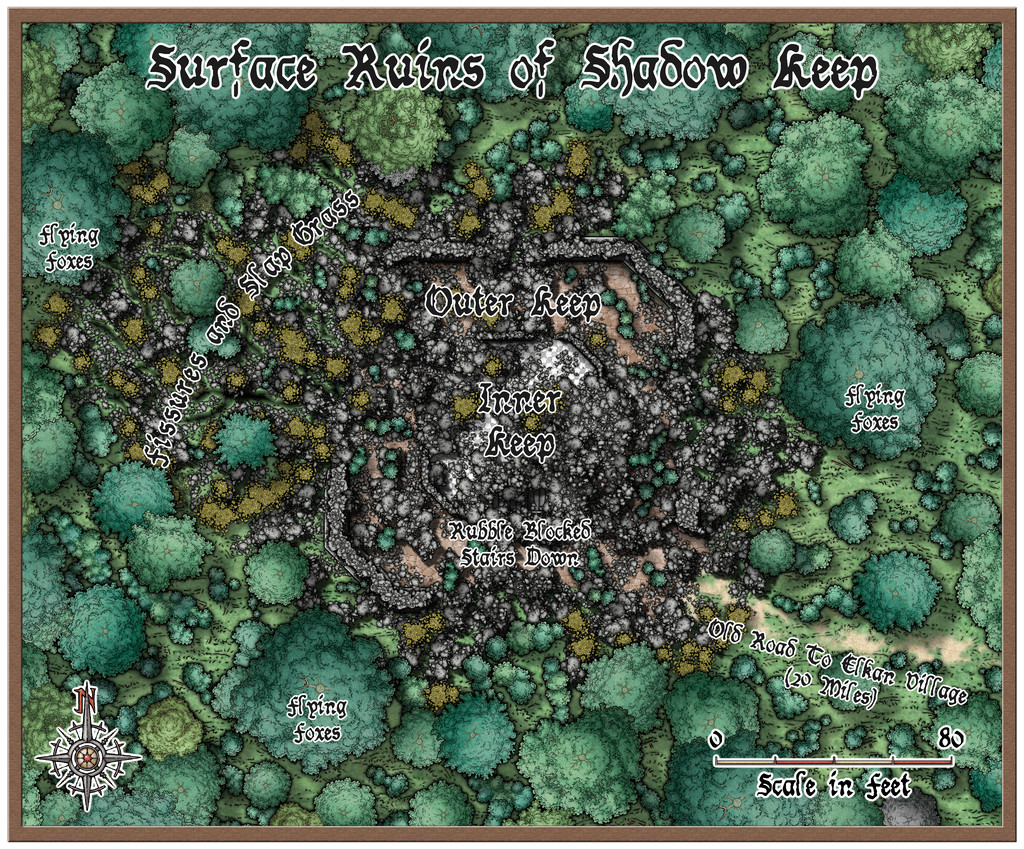
As the mapping was underway, I also designed a couple of surface aspects, beyond the heavy vegetation of the Shadow Woods jungle (which was already placed as present on the earlier Atlas map). This was done again using The Tome of Adventure Design, which came up with the Flying Foxes (terrier-sized canines with prehensile forepaws, bat-like wings and sharp teeth, whose bite carries disease - they like to live in the largest jungle trees with big branches they can easily walk along) and the odd-sounding Slap Grass. Slap Grass grows in patches up to adult-human-tall, and crawls along slowly through rubbly soils using its roots. It has sword-length, wing-shaped, flattened flower heads that it uses to slap at passing creatures (attracted by sensing heat and motion from them, if large enough). This forces its seeds into the creature's skin, and if not removed quickly, once in living tissue the seeds grow rapidly through their host's body, killing the creature in a very short time. And, as the yellow-green patches on the map suggests, there's a lot of it about here!
I decided to keep the map overall fairly simple in its labelled features, and not too threatening in its contents, although GMs could always have a few Forager Elemental Wasps pass through as an additional problem for parties trying to clear enough rubble away to access the underground complex.
Looking ahead for next time, it's a return visit to Artemisia, around the south-centre of that island continent, somewhere in the Lampoteuo Region...


-
Community Atlas: Ruins of Shadow Keep, Malhavania, NW Doriant
As mentioned last time, the next map in this sequence was heading for somewhere in the NW Doriant map, a huge part of that largest continent:
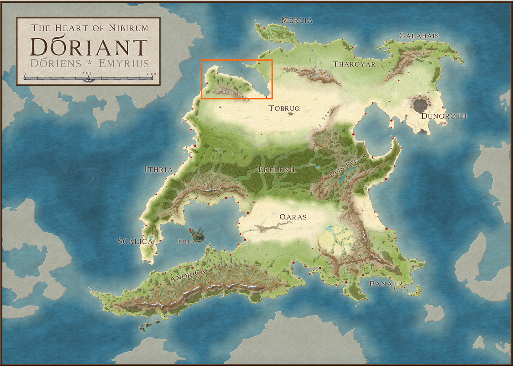
However, when I investigated further, it turned out the Malhavania peninsula there had already been mapped previously. While itself no small region, that did start to look a little more hopeful:
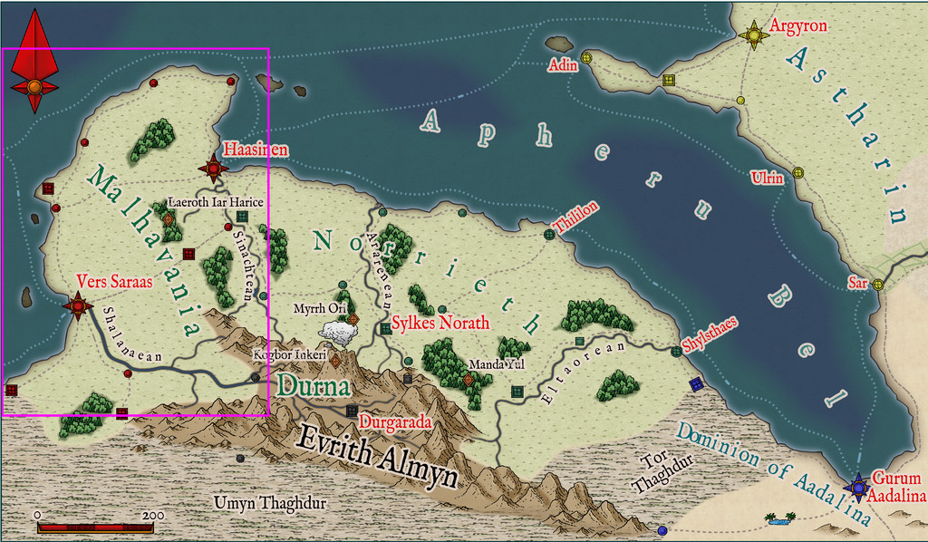
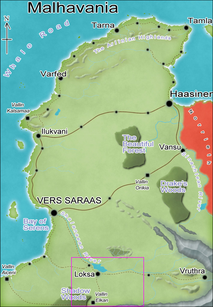
Checking the smallest pre-mapped part of the Malhavania one, around Loksa, clinched things, with its convenient selection of interesting potential sites available to slip-in a small, new, dungeon map:
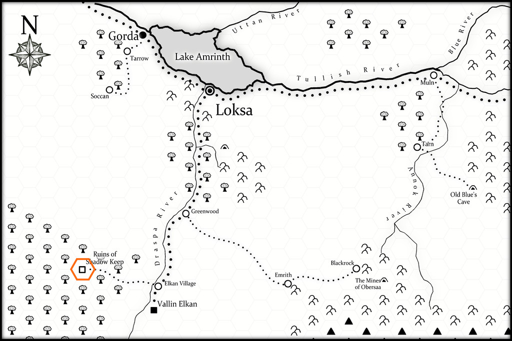
As this final map indicates, I chose the Ruins of Shadow Keep for this site. It's probably not too obvious at this resolution, but the black-and-white area is covered by a hex-map (drawn for the Atlas by Kathorus), with six-mile hexes. I did consider mapping the whole hex, but decided against it finally, mostly because the previous map-group I'd prepared had already been so long delayed in being completed.
The dungeon design was derived this time from randomly-rolled layouts using the Inkwell Ideas Trailblazer Set of Dungeonmorph Dice, the first of the four designs prepared from this set, though I did make a few minor changes to fit better with how things developed for what the contents and purpose of this structure might be/have been ("Ruins", after all). Much of those contents were determined using random tables from the revised edition of "The Tome of Adventure Design" published by Mythmere Games. I only realised after doing so that the Trailblazer dice set actually does have accompanying notes in a separate Inkwell Ideas book! Still, there are three more designs from that set after this one, though I did take a few ideas from that book as well, notably that the original inhabitants of Shadow Keep had been Dwarves, that part of the complex had been a temple, and that another part had been kennels.
One thing the "Tome" came up with were some very weird creatures, which rapidly became the focus for why the Keep had been abandoned and ruined, the Elemental Wasps. From the notes prepared to go into the Atlas: Elemental Wasps. Horse-sized, hairy, spider-form, colonial, egg-laying outer horrors, with three spherical body parts - a small head, medium body and larger abdomen - the body segment with 8 or 10 pincer-tipped legs. Normally invisible, except during and after feeding on blood, when their forms appear pink and sharply-ridged. Attracted to small, shiny objects that they collect as nests. May become ghostly and intangible at will. They have three forms, Queen, Forager and Warrior, of which the Forager and Warrior may cocoon to transform into any other type, as the Queen requires. Cocoons and eggs are always visible.
I also provided the creatures with relevant game stats based on the "Shadowdark RPG", published by The Arcane Library, for GM's guidance. To give an idea of what these (all non-flying) Wasps get up to, these are the notes for the Queen: Elemental Wasp Queen. An almost immobile form, with a huge, egg-laying abdomen and eight tiny legs. AC 12, HP 42, ATK 1 mental burst and 1 lightning cloud or 1 blood suck (near) +3 (1d10 + blood drain), MV close, S +3, D -4, C +2, I +0, W +1, Ch -4, AL C, LV 9. Blood Drain. Extensible head proboscis can hit one target in near. Once attached, may auto-hit each round as the Queen's only attack. Queen regains 1d6 HP per successful attack round. Target may DC 12 STR to break attachment on their turn. Lightning Cloud. Fills a double-near-sized cube extending from the Queen. DC 15 DEX or all within the area take 4d8 damage (DISADV on check if wearing metal armour). Mental Burst. Fills a near-sized cube around the Queen. DC 15 CON or paralyzed 1d4 rounds. Impervious. Electricity immune. Incorporeal. In place of attacks, become corporeal or incorporeal. Invisible. Naturally invisible. After using Blood Suck attack successfully, becomes partly visible. All who can see this, DC 12 CHA or paralyzed 1d4 rounds.
The other forms all have variant powers based on these, with physical pincer attacks as well, and they're a lot more mobile, able to climb vertical surfaces and so forth. There are grubs too, but they're unable to defend themselves, and need looking after by the other mobile types till they become adults.
All of which preamble brings us to the new map:
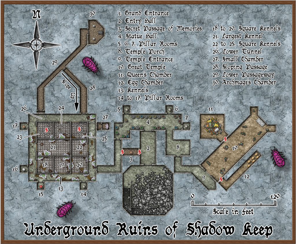
This also has a gridded version, although the angled areas work somewhat less well with that, of course:
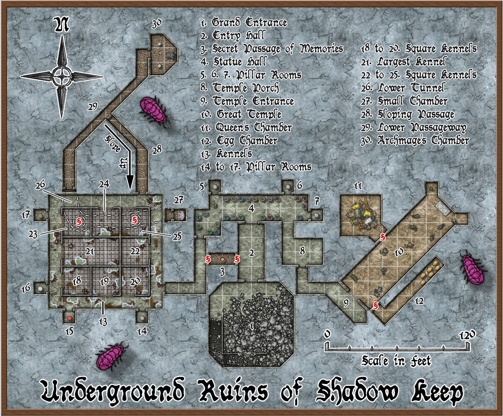
The mapping style here started out as the CA94 Dwarven Dungeons one, given the initial inhabitants were, after all, Dwarves. However, it soon became clear that I needed other elements as well. SS4 Dungeons of Schley and the free monthly "Schley" symbols are already intended to work with Dwarven Dungeons, so that was fine. However, I also ended-up adding items from CA209 Stairs & Steps, Sue's Creepy Crypts (CA186 + CA188) and DD3! So using the Worn Manuscript font from Perspectives 3 wasn't much of a step further...
Of course, when you start a new map with Dwarven Dungeons, the first symbol catalogue that shows up has the cave bugs in it, so while they're not very close to how I envisioned the Elemental Wasps (except maybe the maggot-grubs), I thought they'd do to hint at Things To Come for explorers here 😉.
There is much other weirdness as well. The "Tome" provides opportunities to go to town when designing features such as statues, and having had it come up with a Statue Hall (4), all the statues in it now have individual descriptions in the Atlas map notes, based on those random options, as do the individual pillars in those seven Pillar Rooms (because you can also randomly design pillars using it!). Even the glowing hanging moss across the Kennels area (13 to 25) originated in tables there. The ceiling crevices from which it has grown down from the overlying jungle (the site is at about 25°N latitude on Nibirum) were though my own thought to explain how it got to be here at all, at least. Oh, and there are poisonous little spiders in it that keep away other predators...
One more weird item discovered late in the process concerns the Dwarven Dungeons scalebar. If you peer closely at the gridded version of the map, you may be able to tell the 10-foot grid squares do not match perfectly with the 20-foot marks on the scalebar. Ordinarily, when adding a scalebar symbol, I always check it against the grid, to make sure the size is what it's supposed to be and that I haven't messed it up. Commonly, I also place the centre of the scalebar using the snap grid, as a further test. Doing that showed this scalebar didn't fit to the grid, even after testing with adjusted symbol scaling, including trying the varicolor and metric scalebar versions, in case one worked. All proved identical, however. So then I measured the separation of the marks on the bar at scale-size "1", and found the separation between individual marks came out variably between about 15 and 17 feet, with no consistency, which of course explained things. I did think of swapping-in an alternative bar, but I wanted to try to stick as much as possible with the Dwarven Dungeons style here, so have just left it, given it'll still be sufficiently correct for most uses. Something to be aware of when mapping with this style though, perhaps.
Meanwhile back at the broader-scale map, features such as those ceiling crevices in the Kennels, started me considering it probably needed a surface map as well. We'll come to that next time...
