


Wyvern
Wyvern
About
- Username
- Wyvern
- Joined
- Visits
- 3,240
- Last Active
- Roles
- Member
- Points
- 5,519
- Rank
- Cartographer
- Badges
- 24
Latest Images


-
Community Atlas: Embra - Crossing Places
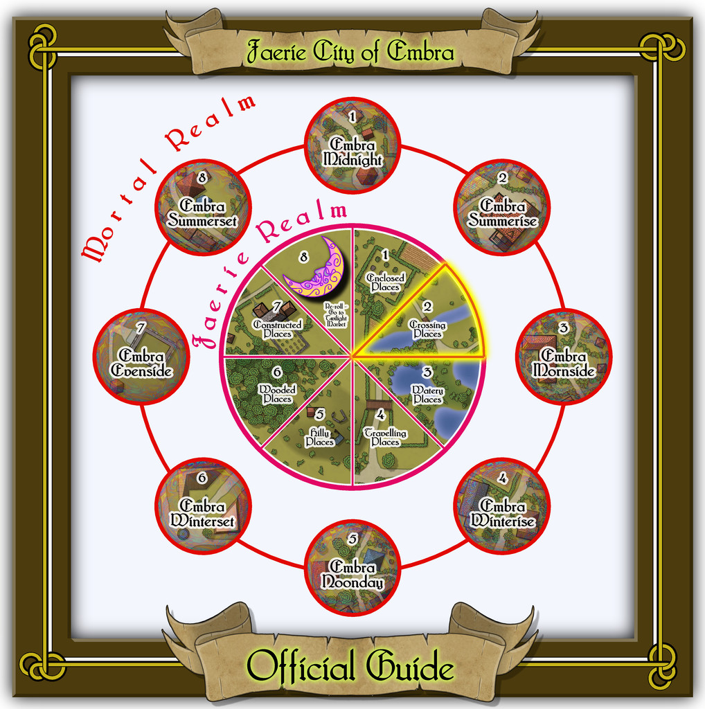
Having discussed the design ideas, methods and overall appearances/layouts for the various Embra "Places" maps in the opening Enclosed Places topic, I'll not reiterate those points here, unless relevant. So moving on, the second set of Places of Interest the Embra "Official Guide" map gives access to, are the Crossing Places:
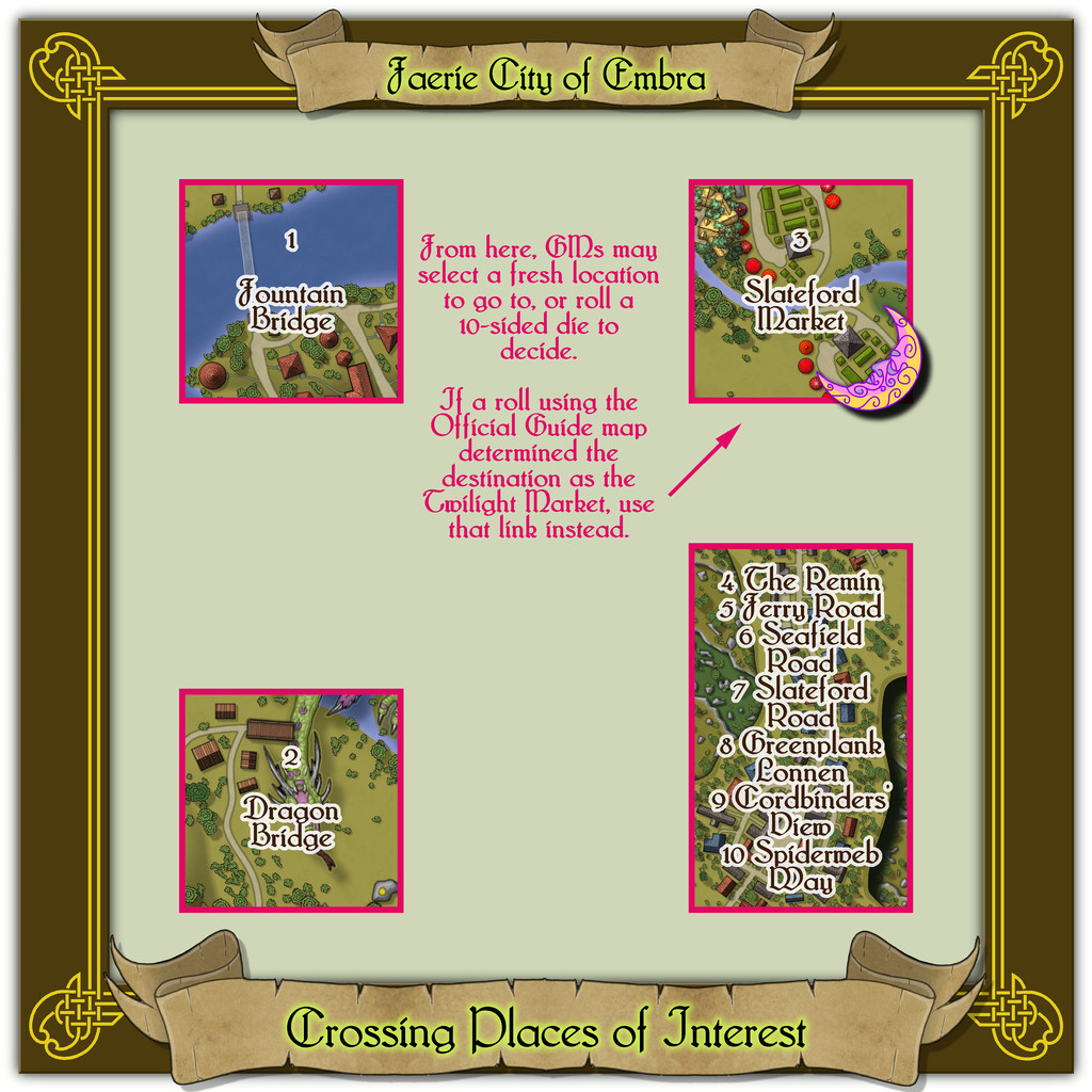
I thought a simpler criss-cross kind of frame corner decoration might be interesting here, partly inspired by that used for the Official Guide map. While the lines along the map edges are easily drawn in CC3+, there was a more elaborate corner-piece in another of the Dover Clip-Art "Celtic Borders on Layout Grids" hardcopy book designs that I thought would add a little more elegance to this map than my own clumsy efforts were able to achieve. As was established for the first of these "Places" link-maps, the link-spaces themselves are just labelled extracts from the actual maps, with added notes for the benefit of GMs, and further reminders in the accompanying text and PDF files. The seven streets condensed into one map here makes for fewer links than some of the "Places" diagrams, though it did mean making that link point larger, to fit all the names in. As luck had it, I somehow managed to get the dragon in just the right place here to avoid running into problems with it wanting to feature itself in others of the link-squares when I added the Dragon Bridge map extract, as of course it's a complete symbol, considerably enlarged, not something that can be easily dismantled to stop it from doing that otherwise!


![[Deleted User]](https://secure.gravatar.com/avatar/c75d9a245b74d9c59be0999ea81ca541/?default=https%3A%2F%2Fvanillicon.com%2F92add7f8c954488718110edc4896ad39_200.png&rating=g&size=200)


-
The Creepy Crypt project
Those are will-o-wisps, by the way ;)
Could have done with these in my recent Faerie-related mapping! Too late now though! Next time...
Sarcophagi is correct from the Latin, but sarcophaguses is also acceptable in English usage. Apparently.
So the real question is, who's the guy in the sarcophagus? 🧟
-
Community Atlas - Dunor Valley - Mt Hasilig Region
I have switched the location of the Hobgoblins and Orcs
They won't like that...⚔️💥😡

-
Community Atlas: Embra - Enclosed Places
Many thanks everyone for your kind comments, "Likes", and so forth. Haven't been on here for a couple of days, so apologies if I've seemed to be ignoring anyone.
I've been working on this group of maps for about six months now, so I've tinkered around with quite a few options, some of which worked better than others, and some of which have ended-up as something of a compromise. I went with the paler mists in the end (and there are some minor variations in the colouring and density in places) as I wanted Embra to be "lighter" in tone generally, although there are a few less welcoming spots too (we'll get to those...).
Well, once the maps are in the Atlas, it should work a little like this, once you find Embra at least. It might have been nice to be able to swap from map to map without needing the linear Atlas structure, but the set was designed specifically for use that way.
They're my own interpretations of images from randomly-drawn tarot cards. These are the notes regarding them that I gave in the opening "Embra" Forum topic:
A few notes were added in the process, but I wanted more, less predictable, aspects too. I turned to two tarot decks, which each coincidentally consist of 78 cards. One card was randomly drawn for each Village, Place and Street from either deck, and extra comments added to the map. The decks were Tarot of the Secret Forest (although this online review page has a lot more images), illustrated by Lucia Mattioli (Lo Scarabeo, 2005), and Shadowscapes Tarot, illustrated by Stephanie Pui-Min Law (Llewellyn Books, 2010). Both are heavily Faerie-inspired in their designs.
The texts were also designed to fit the available space next to the map, and how much text you can type into a single text-box in CC3+, so some of the descriptions were amended because of those constraints too!
-
Community Atlas: Embra - Enclosed Places
The final Enclosed Places map condenses the remaining five Places, all streets, into a single drawing:
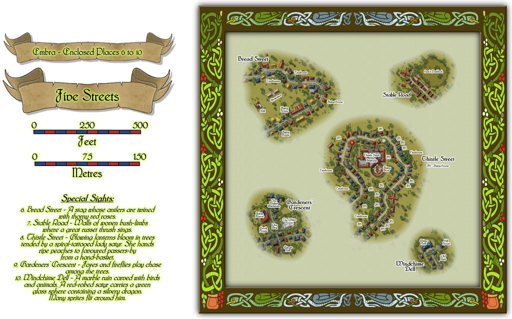
Lots to see here, so let's try a closer view of just the streets:
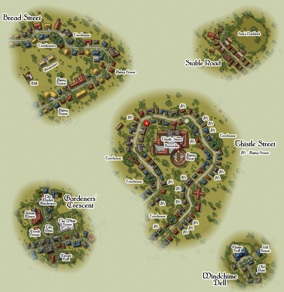
All the streets had to be designed in a rather different way to the other Places of course, as there were no Judges Guild products that provided plans for such things in isolation. As I noted previously, instead I reworked a set of tables for randomly generating caves and mines from another old Judges Guild text to decide on their lengths, widths, types and layouts, although that system ultimately was more "me" than "JG". Once the base layouts were designed and drawn into the CC3+ map, the streets were redrawn as proper CC3+ streets of the appropriate width and character, and then the CD3 random street options were used to populate them with a range of houses suitable for their overall names and natures.
The streets I came up with were often quite curvy, and the CD3 random street tool isn't too keen on curves and turns, and it can't really cope with junctions at all, so some of the random properties had to be moved, or removed, or adjusted, and sometimes redrawn using a combination of the base shapes that had been generated. Occasionally, some were swapped out for symbols, particularly where I wanted specific or important structures to be. I also decided early on that it wasn't going to be practical to provide interior drawings for all the properties involved - there were simply too many, and that ran the further risk of making them too much alike without a lot of care. I did contemplate doing interiors for selected properties, only to finally decide against that too. So if you need interiors, you'll have to come up with your own for these!
I'll not go into detail here as to what some of the items on these mapped streets are. The PDF and text files in the Atlas should help in that respect. However, it is worth drawing attention to the most significant structure, the Thistle Street Barracks, home to the Knights of the Thistle, Embra's military and police-force, in as much as any Faerie settlement needs such things. These Knights are not entirely my own invention either, as real-world Scottish knights of the realm are known as "Knights of the Thistle" too, though Embra's are naturally of a more magically Faerie kind.
As with all the other individual Places, the idea is these streets can be linked as loosely and in whatever ways GMs may desire to create fresh interpretations of Embra city.
And this is only the first collection of Places in Embra. There are six more such sets still to come!


