


Wyvern
Wyvern
About
- Username
- Wyvern
- Joined
- Visits
- 3,240
- Last Active
- Roles
- Member
- Points
- 5,519
- Rank
- Cartographer
- Badges
- 24
Latest Images


-
Community Atlas: Embra - Hilly Places
Next is another Edinburgh-influenced location, this time based on the huge, semi-wild, volcanic-rock hill of Arthur's Seat. In Embra, this becomes the large hill named Mab's Couch:
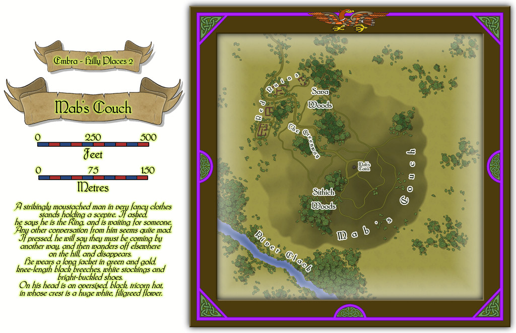
As Arthur's Seat has a number of walking trails across it, it seemed reasonable Mab's Couch should have some as well, and the focal point of a stone cairn at the top. The red sandstone ruins that might never really have been buildings are a purely-Embra aspect though, as is the oddly-dressed madman (?) of the featured text. When thinking of suitable place-names, I felt it might be apt to add something with a perhaps more tangible frisson for potential RPG character visitors, hence Sithich Woods, as, from the accompanying PDF and text notes for this map:
A Sithich is a mischievous upland sprite that uses deadly weapons made of flint-like stone. Such flinty stones can be found lying scattered in places throughout these woods, although only the more unfortunate might encounter an actual Sithich as well.

![[Deleted User]](https://secure.gravatar.com/avatar/c75d9a245b74d9c59be0999ea81ca541/?default=https%3A%2F%2Fvanillicon.com%2F92add7f8c954488718110edc4896ad39_200.png&rating=g&size=200)

-
Community Atlas: Embra - Hilly Places
The first of the Hilly Places of Interest is a rocky mound by the curiously narrow River Clack, Palace Heights:
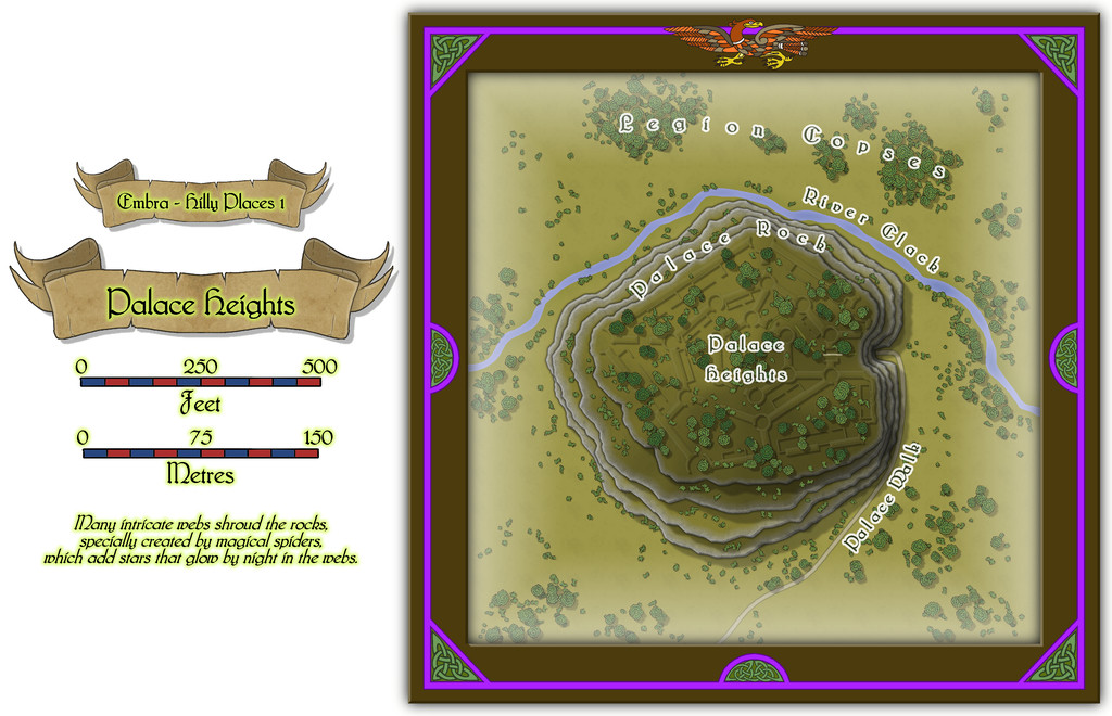
No real sign of a "Palace" as such, although that maze of low, grassy features all over the slightly domed hilltop hints that something may have been here once. This is one of those Places I'd had an idea or two about before the project was too far along, and parts of this map will recur in a subsequent one from the Constructed Places, where the Palace isn't just a series of grassed-over ruins. Faerie time-dilation effects can permit all sorts of weirdness, and in this case, both the hill with ruins, and the hill with a fully-functional Palace, can coexist simultaneously in Embra. The particular one to be found - perhaps even both - dependent on how the city is navigated.
The original concept came about loosely because the real-world city of Edinburgh, which was an early influence for Embra, has its own great castle-palace, set upon a rocky pinnacle in the city, although the two aren't closely comparable beyond that, chiefly because each of the Places for Embra being unconnected from any others, has to be presented on a more-or-less standalone map, whereas Edinburgh Castle's rocky platform continues down into the adjacent street area leading up to it, known as the Royal Mile.
-
Community Atlas: Embra - Hilly Places
The next, fifth, group of Embra's "Places" is the Hilly Places of Interest, linked from the highlighted "Official Guide" map's inner circle segment:
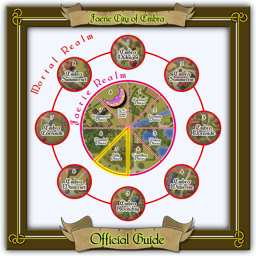
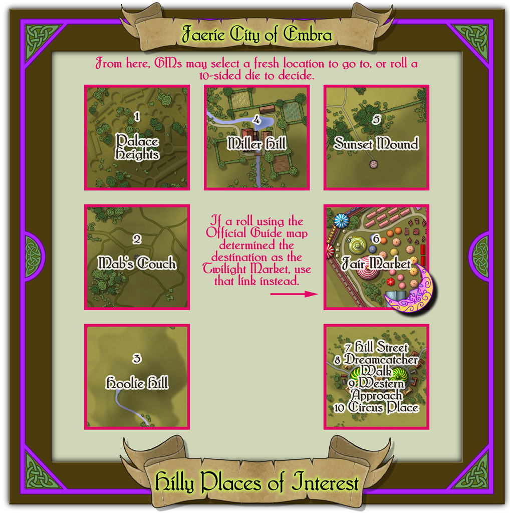
Quite a packed link-map this time, with six individual mapped places to show, as well as the condensed "Streets", even if just four such routeways had to be set-up on one map this time.
Two neat knotwork designs reworked from the Dover Clip-Art "Celtic Borders on Layout Grids" book provided the focal elements in the map frame design here, once rotated, with a simple linear connecting outline to help highlight them, the curved piece and triangle's slope hinting at upland places at least, although another of the figurative Dover book designs, an eagle, was used on the other "Hilly" maps in this set as a further concession to upstanding terrain.

-
dd3+ crashing combining paths
As far as I can tell from the FCW file, although you have two separate arc lines for the sides of the polygon you're wanting to draw, you have multiple entities for where the straight end pieces should be, so I'm not sure which are the "4" entities you're trying to connect.
The rectangular room that the top of the two arcs are adjacent to consists of three entities, all on the "temple area" Sheet, one on each of the BACKGROUND (FLOOR 1), BACKGROUND (FLOOR 2) and WALLS Layers.
The corridor rectangle at the base of the arcs consists of two entities, again both on the "temple area" Sheet, with one each on the BACKGROUND (FLOOR 1) and BACKGROUND (FLOOR 2) Layers.
Now, as far as I can tell by zooming in, your two arc lines do not connect with ANY of these five entities - or sometimes one end of one arc might, but not the other. So I think the problem may be that you're trying to create a polygon from lines that don't connect with whichever of the entities you want them to at all.
You may find it preferable to create the polygon you need from four simple lines such as you have currently - that is, zero-width black lines - then convert those to a polygon of the appropriate fill. As long as it's on the correct Sheet, it should flow into whichever of the other polygons you need it to.
You may want to rethink how you're drawing the map overall before that, however, as you can only apply Effects to Sheets, NOT Layers, and having all your floor and wall polygons and lines on the same Sheet means they will all look very flat, and hard to tell apart. The three Layers I've mentioned for the entities you have drawn already here would be better as Sheets, with all those Sheets on the "Temple Area" Layer - because the Layers simply act to group all these Sheets together (so you could hide everything on the Temple Area Layer simultaneously, should you choose to, for instance). Just a thought.
Not sure if this will solve your problem, but if not, hopefully someone else will have some more useful suggestions.

-
Community Atlas: Embra - Travelling Places
Which brings us to the last map in this group, covering the eight "ways":
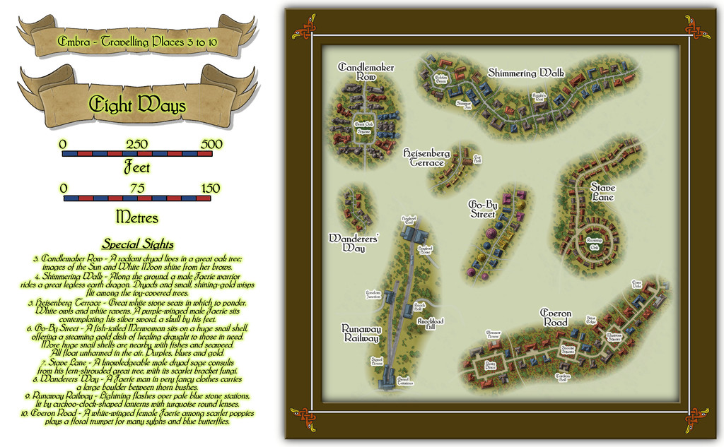
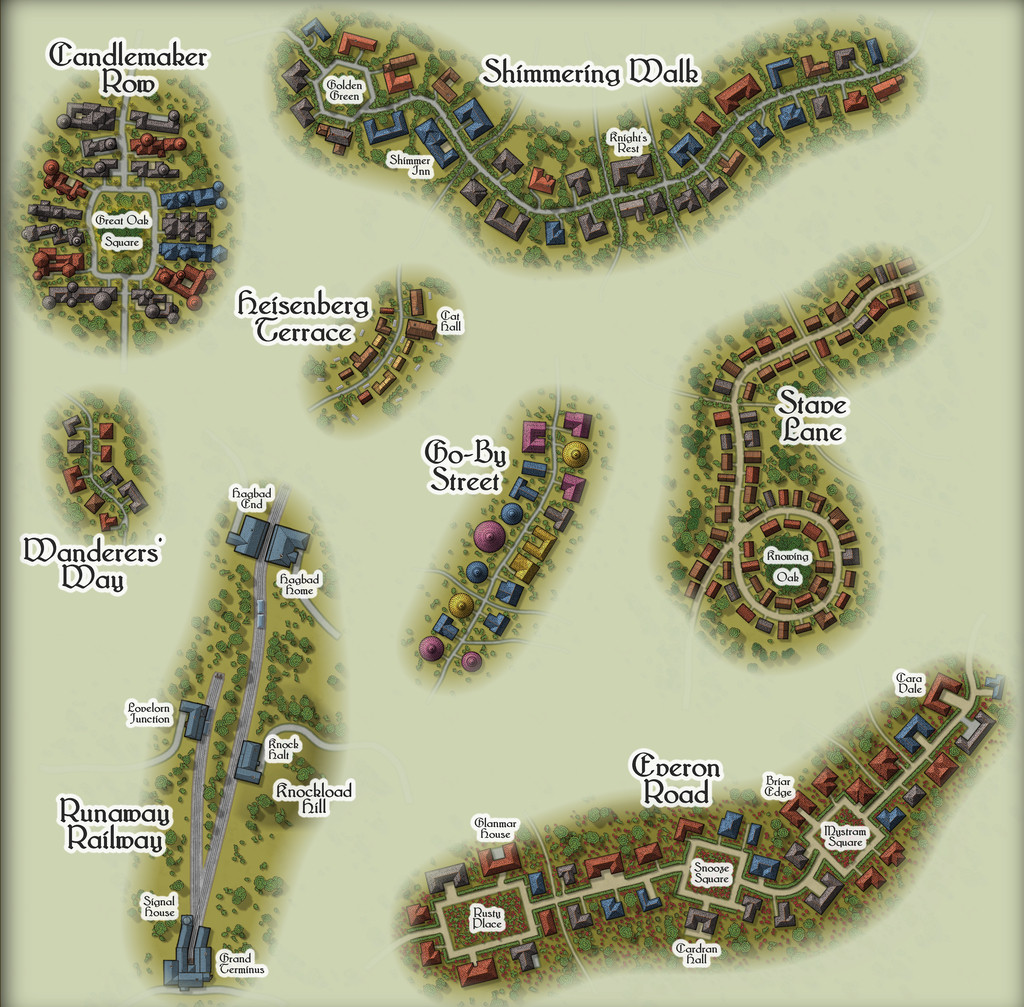
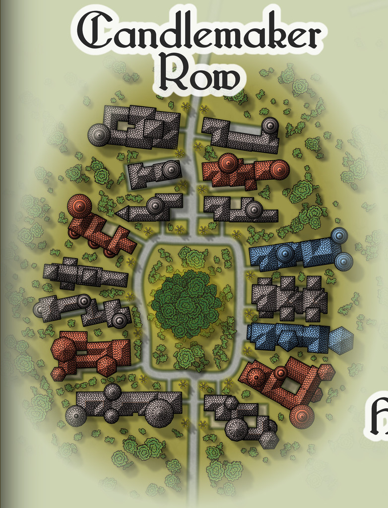
While the seven streets were constructed randomly from the simple system I'd devised and used previously, the railway needed some further adaptations, reducing the angles turns and junctions could have, and such like. In drawing the final maps, I kept the roads deliberately free from as much obstruction as possible (vegetation and the proximity of the properties along each), since the essence of Travelling Places relates to movement. In the accompanying notes, I've suggested GMs should allow speedier normal movement when using any of these routes, as long as the party sticks to the way itself. And naturally, there are oddities. Such as the large, complex building shapes along Candlemaker Row, where sadly, I fear the giant standing candelabra that light this route at night will be barely visible, and likely unidentifiable, at the Forum's resolution on the above maps. So let's try this view instead:
That weird loop in Stave Lane came from the construction process alone, which was a pleasantly amusing surprise when I plotted-out what the dice had rolled for the first time, especially as it made Stave Lane - a name yielding expectations of being straight and direct - one of the most convoluted of Embra's mapped streets!
Heisenberg Terrace, naturally, isn't always there, while the bazaar in Cat Hall is run by a humanoid feline, Shrew Dinger... Go-By Street is easily missed too, without care (aside from being a test for people's knowledge of fantasy literature; a good spot to place The Genuine Magic Shop, perhaps - despite its different author). The literary origins of Everon Road's name might be an easier test though.
As for Runaway Railway, aside from the real-world city of Edinburgh (very loosely the inspiration for some of Embra's place-names, as well as its actual name) being a major railway centre in Scotland, it also has the surviving remnants of a far earlier horse-drawn passenger rail-line, the "Innocent Railway", so I felt I had to include a railway of some sort in Embra. It's obviously short and simple, though as with everything else in Embra, its size can be as deceptive as GMs require. Rather than get bogged-down in detailing the line's operation, I chose to have the rolling stock run by the magical forces of electrickery (see Wyvern Citadel on this, if necessary). Conveniently, the featured text - and remember, these things were chosen randomly! - involved lightning flashes, which made that decision very easy.

