


Wyvern
Wyvern
About
- Username
- Wyvern
- Joined
- Visits
- 3,237
- Last Active
- Roles
- Member
- Points
- 5,515
- Rank
- Cartographer
- Badges
- 24
Latest Images


-
Community Atlas: Kara's Vale, Ethra, Doriant
Back to topic!
Windy Tower: Sited near the east bank of Summer River in the Kara's Vale map's northwest, northeast of the line of Quarry Cliffs, and surrounded by jungle, is this fabulously ancient Tower, said to be a Wonder of the Ancient World. Notable for its unusual red stone.
Which is a slight paraphrase of the Kara's Vale map notes about it. I'm not sure quite why, but my thoughts for how this might be mapped drifted away to a 50-year-old fantasy skirmish wargame from 1976 called "Citadel: A Quest Within A Wizard's Tower" published by Fantasy Games Unlimited. This used basic thin-card-printed maps (brown ink on pale yellow card) drawn to 25 mm scale (the general height of cast-metal, normal-human-sized wargame miniatures back then), with square, thin card markers for the creatures defending the tower, the treasures and traps inside, and the connections between the different tower levels. Hero miniatures had to be provided by the players, and their relative strengths also decided that way, which made for quite a bit of work in advance, before being able to play the game originally. There were six card maps, printed on both sides, giving a dozen different floorplan layouts, only six of which were used per game, and the blank reverse counter sides created a fog-of-war situation, meaning the heroes had to check every counter to navigate their way between the tower's levels, find the treasure, and battle the monsters, without knowing what each counter might be in advance. As a game, it was OK, though often quite lengthy to play, and the card markers made it very easy to accidentally knock things out of position, albeit these were common elements in other games of the period. It also didn't look great, so we sometimes substituted monster miniatures for the card markers, only to then forget what strength each monster was meant to have... Joys of youth, eh?!
Feeling this to be a suitably Ancient Wonder of the World, I thought it would be interesting to adapt it for the Windy Tower maps. The floorplans meant the layouts for each level were available straight away, although those were amended in places to add doors (the original game had none) and a few extra walls. The connections between levels were originally portals in essence, because any on a given level might go to, or from, or both to and from, any other level in the tower, a concept retained here too, along with the two main treasure options, an amulet and a talisman, and the use of three types of defending creatures. In the original game these were "humans", "near-humans" and "non-humans" of varying numerical strengths. That, and the general "ancient" concept, drew me to warriors and mythological creatures from ancient Mesopotamia on Earth, because artworks from the 3rd to 2nd millennia BCE and later there show a similar range of beings - humans, demi-humans and non-human creatures. We know very little about any of these, even archaeologically for the human warriors, so there'd be options for some suitable expansion and interpolation of fantasy elements here.
Having got this far, with a list of possible options for all three defending creature types, some semi-random rolls helped decide what was where (limited so as not to have too many creatures or portals on any given level), after a further decision had been made to use all twelve tower floorplans, so Windy Tower would have twelve levels. Naturally, not all the creature options were chosen in the final version, but those that were are all provided with notes in the Atlas version (and here too for clarity), with statistics for the Shadowdark RPG, to help provide some pointers to their strengths, powers and abilities.
And so to the map. As each level in the Tower is an identically-sized square in area, there was the possibility of setting up twelve separate Atlas maps, using a simple copy & paste option between each map to draw their outlines and other basic features. However, that seemed a bit "ordinary", and as part of the point of this project has been to try new (for me) things from time to time, I decided instead to draw the Tower in a single map, with the contents for each level on its own Layer, and then to set-up hyperlinks for the portals on each level that would then allow one click on said portal to show each Tower level as it was encountered, using the FCW version of the map. After first checking with Remy Monsen to ensure A) that this wouldn't cause problems with the normal Atlas navigation processes, and B) that I had the correct macro commands to actually do this!
Following which, the mapping could begin. As the connections between levels were randomly set, including the surface entry point, the first level encountered when approaching from outside is Level Five:
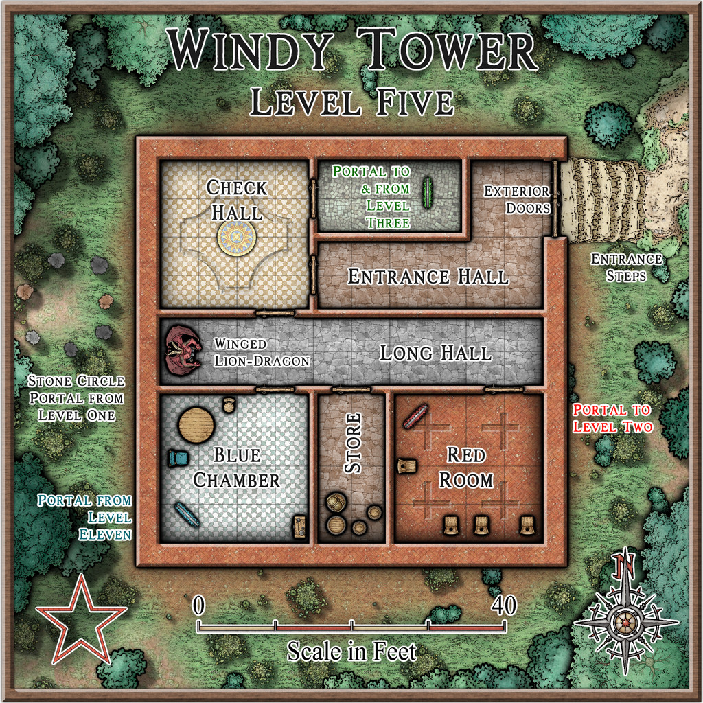
While the original floorplans were fairly basic, they did commonly show variations between the flooring in separate areas, so something of that concept was adopted here too, with effects and furnishings to liven things up further.
One significant problem was finding suitable markers for the different defending creatures per level. I'd already decided that these would appear as statues until activated by intruders in their part of their own level, so their starting locations needed to be identified. However, the range of top-down statues and creatures in the Mike Schley style - even with all the monthly symbol options - is extremely limited, especially as some of the statues have large bases as well. Adding the original DD3 creature options only helps marginally, again thanks to a limited range of options, most of which don't include varicolor that will allow creatures to appear as statues instead. So the creature options used here were purely a compromise, using varicolor shading at times to separate the different kinds, and occasionally adjusting the sizing as well for the larger non-humans.
From Level Five, we have portal options to go to Levels 2 or 3, but rather than following such convoluted paths in showing the rest of the maps, the remainder will be presented simply in numerical sequence.
That though will have to wait for another time - like the notes on what a "Winged Lion-Dragon" might actually look like!


-
Galery of NPC
I think most, if not all, the character items are indeed from Character Artist, RS - I recognise many of them, certainly!
-
Community Atlas: Kara's Vale, Ethra, Doriant
Returning to Doriant for my next Atlas maps, this time I was heading for somewhere on Ethra, the huge island in the great, almost-landlocked, southwestern sea there:
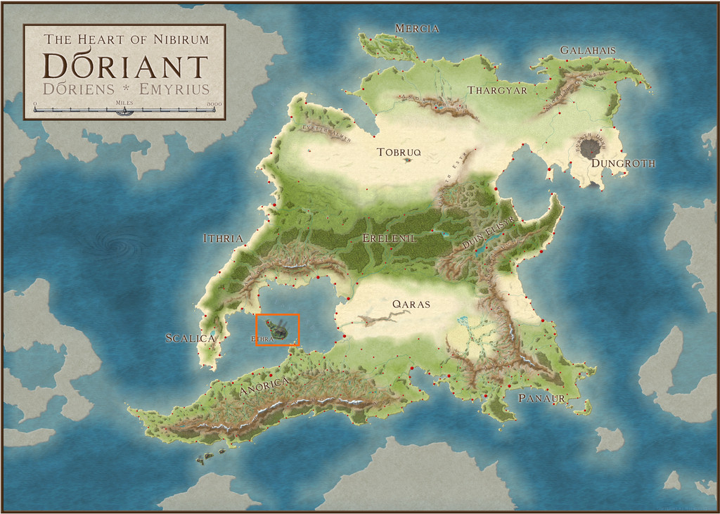
Examining the notes for Ethra indicated the island was split into a series of provinces, although much of those descriptions centred only on the major settlements, so it seemed there'd be plenty of options to slide-in a small dungeon map somewhere unobtrusively, even when surrounded by one of the typical 20-mile-square area maps I've favoured for much of this project. The Inkwell dice-map dungeon layout had already sparked vague thoughts of something alchemical, so a quiet spot might be useful, and while there are plenty of such potential places in the vast, volcanic barrens on Ethra, my eye kept being drawn to a small, labelled area, Kara's Vale;
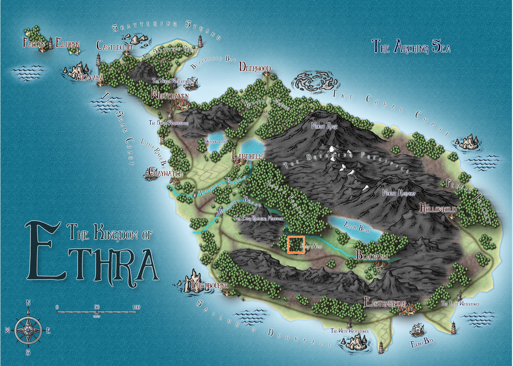
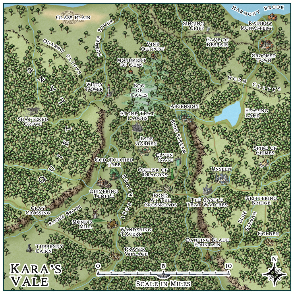
The way this area was mapped intrigued, as the Vale's woodland looked to be sunken compared with the woods to either side, yet had no major river shown flowing through it. With the volcanic nature of the whole island, this made me think of a small rift valley, so that's what it became:
In an effort to persist with using linked mapping styles for this area, I decided on the Mike Schley styles (SS4 for the dungeon and the surface entrance site), something I've not really used much for overland mapping before. While the original Ethra maps showed deciduous and conifer woodland symbols, because the site is in the tropics, around 23°S latitude, here I went with "jungle" style trees instead. As I wanted to suggest higher plateaus to either side of the Vale, there was a bit of a battle to show the north-facing cliffs, as such options aren't available in this style, so I had to use the normal cliffs, and then hide everything except the upper parts with a suitable land-textured mat, something adding a second, lower, cliffline in the northeastern corner, greatly complicated! However, the jungle helps hide most things, one way or another...
The general map design was set by how the shadowed valley and unshadowed woods were shown on the Ethra map, and where the major river, just on the northern edge here, lay, while the specific features were all placed randomly, using my usual grid and dice method, with a one-mile grid spacing. What those places were was determined using or interpreting cards from various prompt decks produced by The Story Engine, a little like last time's for the Selenos maps in Artemisia, except this time also drawing from their "Deck of Worlds" as well as the "Loremaster's Deck" main sets, plus the "Worlds of Myth & Magic", "Loremastery" and "World & Lore Bridge" expansion sets. That's where pretty well all the on-map names came from too.
Map notes expanding on some of the place-names, again largely based on what the cards came up with, will be in the final Atlas version of the map, and also much as last time, the cards inspired thoughts and details beyond what I'd expected, which of course is their whole point. As for where the dungeon layout might be placed, there wasn't a shortage of possibilities. Ultimately, Windy Tower, northwest of the map's centre, won out, as we'll see next time.


 and 1 other.
 -
Flooring Maps
Glad you got that sorted. Those are nice-looking floorplans!
Ellipses are fairly straightforward in CC3+. Just right-click on the Circle drawing tool icon - |CC2CIRP| - to call up the options list, and there's an Ellipse tool right there.
Spirals are a lot trickier though. Remy Monsen wrote a blog post about creating a macro to draw a spiral here, and although writing macros like this is pretty advanced stuff compared to simply drawing things and placing symbols using the program, they will let you automate much more sophisticated tasks with elegance. That blog post is the third in a short series of three on using macros, and you may find it useful to read through all of them (there are links at the end of that "spiral" post) if you're unfamiliar with how they're written before embarking on spiral design tests. And as usual, if you get stuck, just ask again here!

-
Wyvern's Wood - A Handdrawn Fantasy Map
Seeing the maps appearing on the Forum using this new style already, it's perhaps unsurprising I've felt the need to join in, as much as anything because the main sample map that comes with the Handdrawn Fantasy Annual style included The Wyvern's Wood!
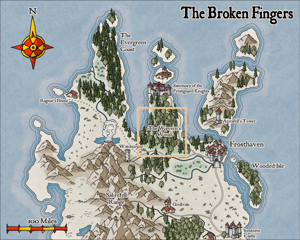
In a break with my usual mapping too, this one isn't intended for the Community Atlas (although it's possible it may eventually feature there, probably in a variant form). That orange outlining square shows the region I picked to illustrate from the sample map.
Having had a long fascination with woodlands for fantasy mapping and scenario designing, I was somewhat spoilt for choice as to which of my previous RPG-related settings to draw upon in creating this map. What I went with was a selection of items from a storyline drafted in 1993. I'd intended it originally as a one-off scenario, run using the Call of Cthulhu rules, for a twice-yearly gaming convention I attended for much of the 1990s. The design though grew into something that needed a longer timescale as a short campaign instead, and ultimately, it was never run at all.
That scenario was a modern-day one, set initially on Bodmin Moor in Cornwall, England, and which included various loosely Arthurian and mythological items, then increasingly introducing horror and surreal elements, rising to a chaotic finale. What I've extracted from it here are specific significant locations, adding them to the new map in no strong order, since the originals were designed to be encountered in only a rough order anyway - and in some cases repeatedly. Most of that detail and pathway structure has naturally been omitted here.
So this is what I came up with:
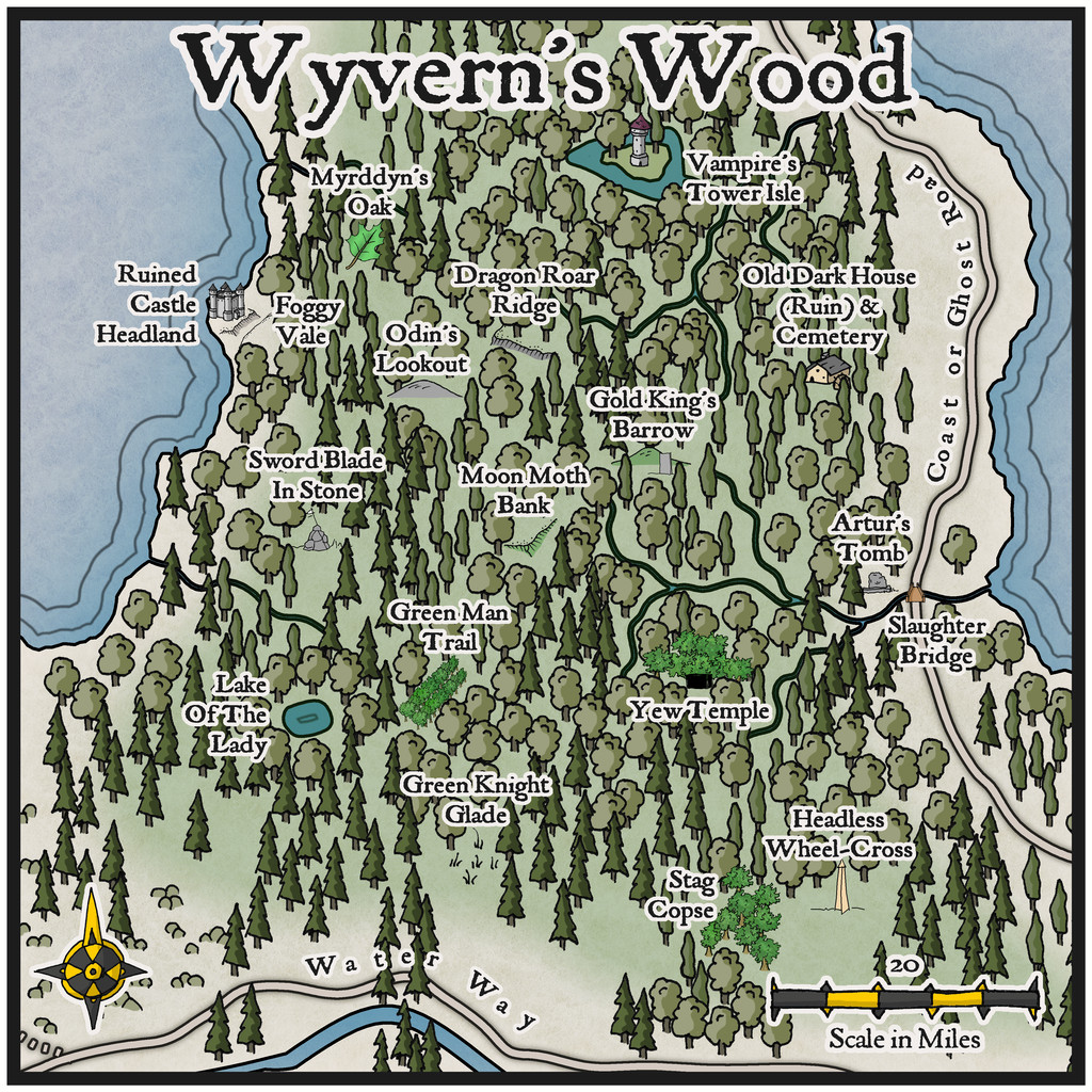
As is obvious though, I had to draw on other handdrawn styles from SS1 in identifying the various features, to highlight them sufficiently, and their sizing is of course hopelessly out of scale, as so often happens with this kind of pictorial map. Maybe though some of these added symbols might give some ideas for future expansions of the new style!


 and 1 other.

