Wyvern
Wyvern
About
- Username
- Wyvern
- Joined
- Visits
- 3,238
- Last Active
- Roles
- Member
- Points
- 5,515
- Rank
- Cartographer
- Badges
- 24
Latest Images


-
Community Atlas: Errynor - The Isle of Zariq
As promised when I posted about The Cliff map, this is the first of the additional maps to accompany it, covering the Isle of Zariq, the surfaced tip of the huge seamount of the same name in the Frigid or Equine Ocean, some 750 km (470 miles) off the NW Alarius coast of Errynor.

I realise this may come as a shock, compared with many of my previous Atlas contributions, but there's just one version of this island's map!
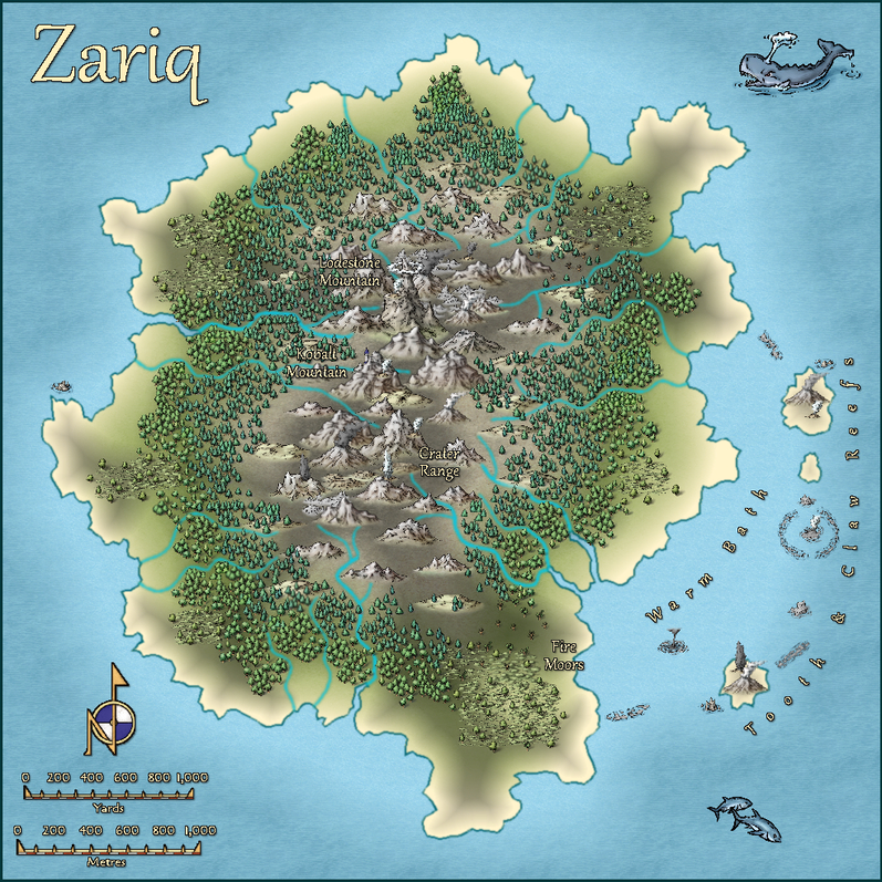
In-keeping with the element of chance employed to a greater or lesser extent in all my previous Atlas items however, the original base map was generated randomly, using the island generator on the Red Blob Games website. The final map has been reworked to some extent to better fit with what was intended here, though not by much.
The terrain symbols and some names are a little misleading (deliberately), as a quick check of the scales will show the entire island is only circa 4½ km (2¾ miles) in its largest dimension. The terrain is craggy and volcanic, as the surface sits on the main seamount's vent (it extends to the eastern offshore Tooth & Claw Reefs, so is partly underwater). The highest peak however, Lodestone Mountain, rises only 100 m (330 ft) above sea level. Smokes, mists and minor eruptions, including of geysers, are common features. The vegetation cover is generally stunted and windblown. Most of it produces plentiful seeds or berry-like fruits, as it was chiefly brought here by seabirds.
Indeed, seabirds are the main obvious living creatures for newcomers to the place, and those mainly during their spring-summer breeding seasons. There are also many kinds of small insects, arachnids and other invertebrates. There are additional creatures less commonly seen here, as outlined in the map's accompanying PDF and text files, of which perhaps the more intriguing is a tribe of small, blue-scaled, reptilian humanoids, the Kobalts (= D&D's Kobolds), who live in a warren of tunnels beneath Kobalt Mountain. For once, and despite the classic RPG random dungeon design joke from the early days of D&D, that "I just rolled for 40 Kobolds in this broom closet", this was in fact a long-standing decision, not a randomly generated one ?


![[Deleted User]](https://secure.gravatar.com/avatar/c75d9a245b74d9c59be0999ea81ca541/?default=https%3A%2F%2Fvanillicon.com%2F92add7f8c954488718110edc4896ad39_200.png&rating=g&size=200)
-
A couple maps
I think the hex-size and location-scaling issues stand out so much for me because my experiences with hex maps began with the SPI board wargames, where hex-placement of symbols and units was absolutely key, and that translated into the earliest RPG hex maps I worked with, those by Judges Guilds, where again the settlements were scaled into the hexes, with things like isolated strongholds and towers reduced to very simple, tiny, open squares and circles, so small it was often hard to find them quickly, which is perhaps pushing too far towards the other extreme!
For the village places that need to be in better communication, it would be possible to have them stay where they are, but introduce much more direct routes between them. This might mean redesigning other parts of the village to fit - reasonable, because the village would have grown up around such existing routes. If the houses had been there first, the important places would have been sited differently, to allow those more direct routes to be possible from the outset.
There's a fair chance the marketplace would have ended up more central too, as in reality, such things often started out on the Village Green, an open area in the middle of the village to allow community events originally. It could be moved to somewhere more peripheral if it needed additional space the Green area couldn't provide. The Inn would likely end up by the Green too, again as a handy near-central location. If the market moved, the Inn might have its effective facing altered, or simply expand (if space allowed) to provide patron access from all the suitable directions.

-
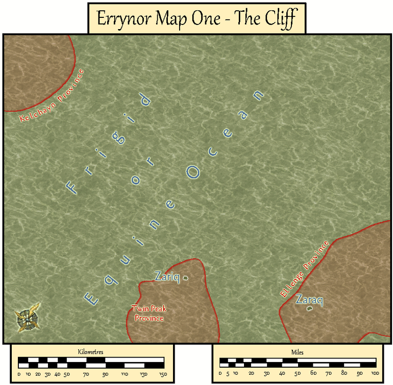
Community Atlas: Errynor Map 01 - The Cliff
With the new undersea symbols ready, finally I could begin constructing the first map. Logically, this was to be my original Map 1, at the top left corner of the Errynor map:
Clearly, the seabed was going to be the primary aspect here, with just two tiny islands above sea level, so that's where I began:
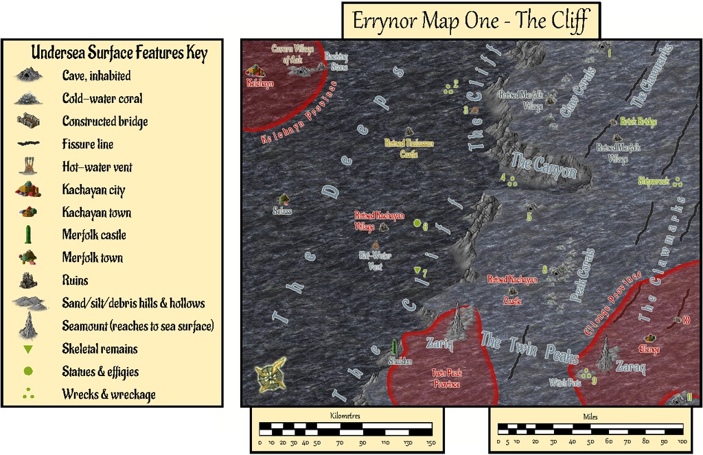
The tremendous cliff at the continental shelf edge is so dominant here, that had to become the map's name, while the relative sparsity of other undersea surface features had been a deliberate choice from the initial planning of the main Errynor map. What items are shown, are thus those more easily found by new travellers to the area, or those whose presence is more influential for whatever reason. This also reflects the apparent nature, as far as can be established, of Earth's own ocean floors. The shallowest seabed mapped here, towards the lower right corner, lies below some 300 m (nearly 1,000 ft) of seawater, for instance. It further fits with the idea of the relative smallness of the undersea intelligent populations in the region, compared with the vastness of Nibirum's oceans, as I'd envisaged them. There is the further advantage that plenty of space is available for GMs to add extra points of interest, should they wish.
The red-limned regions are Kachaya/Sea Devil provinces, incidentally.
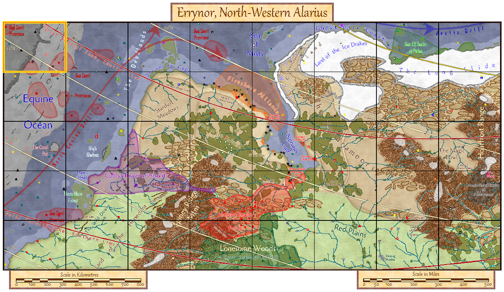
I added a SOLAR/GEOMAGNETICS Layer overlay to show lines of latitude for each 1°, and the midline for Nibirum's polar auroral zone. This option should be available by a toggle for the Atlas version.
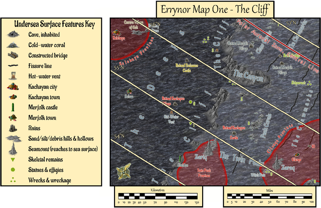
These 250 x 200 mile maps are small enough for the north direction to be fairly consistent across most of the area covered, so I'd been able to add a compass rose as well, which hadn't been possible for the main Errynor map.
When designing the hand-drawn paper maps at the start of this project, a selection of larger/more interesting/more dangerous creatures (and things, for the solid surface) that could be encountered had been randomly included. Many of the undersea types were free-swimming. For RPG use, it's naturally important to know where these are not merely for the sea and undersea land surfaces, but in the water column between too. Hence another map toggle, activating the UNDERSEA WATER COLUMN Layer, is intended to shift the view to that water column (it's best to turn off the TEXT, SURFACE UNDERSEA Sheet for clarity first):
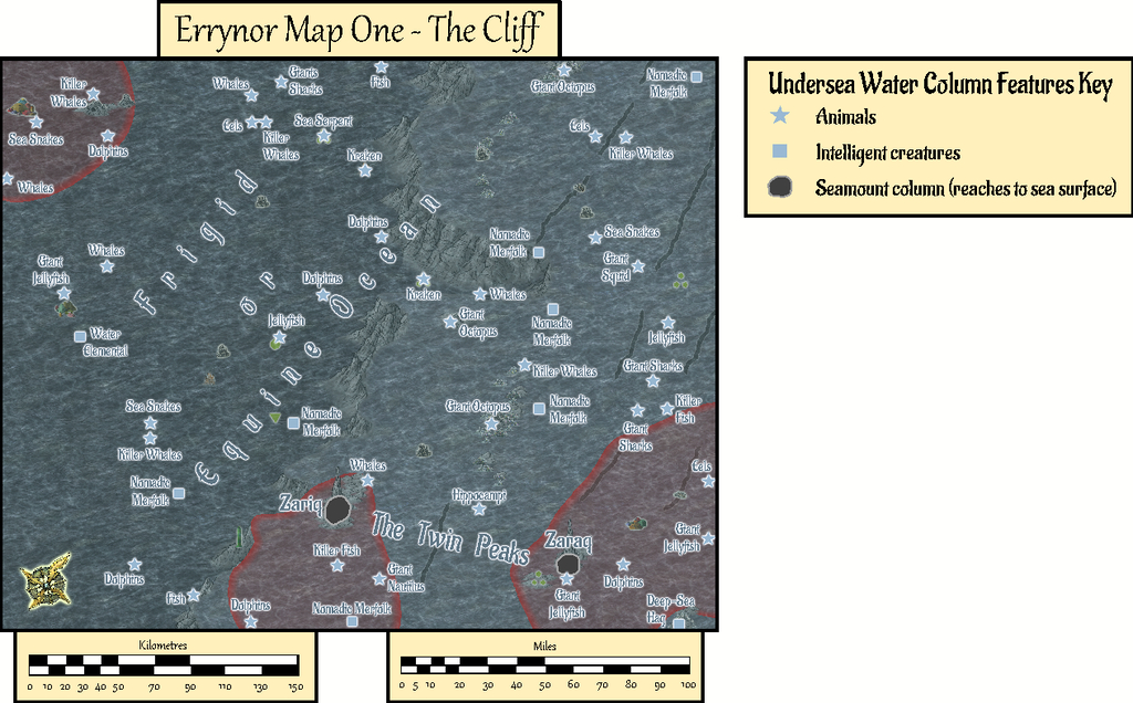
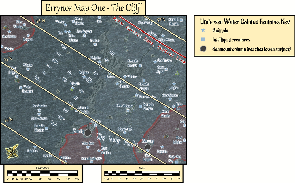
This view isn't at a fixed depth below the sea surface, simply to illustrate in general what can be found somewhere in the water column. Thus although the great seamount rock columns of Zariq and Zaraq have been given physical dimensions here, those are representative only. An 11-page PDF of the map's accompanying text-file notes explains this, together with detailing various of the other more noteworthy features shown.
A third toggled view, turning on the COAST/SEA Layer, shifts us to the sea's surface, where the seamounts have become small islands, and the midwater denizens have been joined by several ghost ships and an area where floating wreckage collects from time to time:

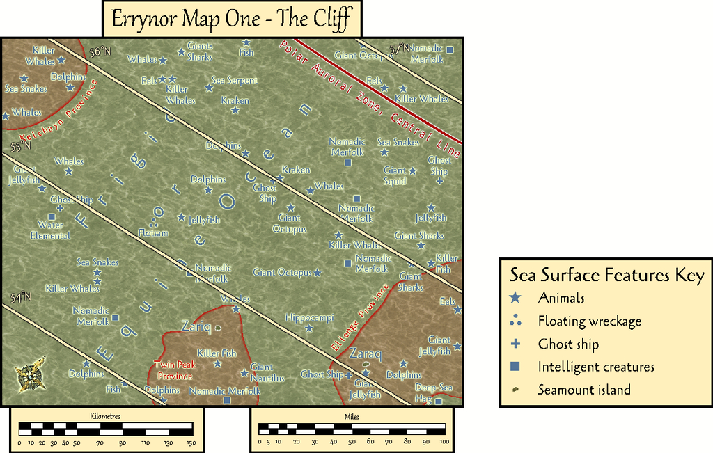
By turning off the SYMBOLS, SEA SURFACE Sheet, the paucity of sea surface features is very clearly seen!
GMs here may be unsurprised to learn I became distracted by some of possibilities of this map while drawing it into CC3+, as I've hinted in some of my more recent Forum posts here. Consequently, instead of progressing immediately to the next Errynor sub-map, I embarked on a group of feature maps from this one first. Plus, it also seemed unhelpful to not provide some guidance regarding the nature of the undersea features, especially the sea-bed settlements, for future mapping, as this is something scarcely touched-upon by published RPG settings and adventures. Thus this one map has become merely the first in a package of around twenty from this one area, which explains much of the delay in getting them ready for the Atlas, given I felt the whole group needed to be finished before any were submitted, in case changes were needed to those prepared earlier in the sequence - and that has happened along the way.
In fact the maps were prepared relatively quickly in each instance with CC3+. The most time-consuming aspect has been preparing and checking the detailed write-ups for them, as these are what has particularly allowed me to explore and expand upon ideas regarding fantasy undersea environments that I've been mulling over in part for decades.
Rather than drop the entire set on Monsen at once, my intention is for a gradual "release programme" with a new map or map-group only every few weeks. Maybe this will give me time too to complete more of the "Errynor 40" maps along the way, hopefully not taking quite so long each...


-
A couple maps
The area map looks pleasing in overall style, though I'd suggest a different scaling. Some of the symbols are far too huge to tell where they're meant to be, given the hexes are a mile across each. It might be worth considering shifting to the classic "Old School" style hex maps, with a single terrain feature or item per hex of whatever size, perhaps, if you want to retain the hexed look. If retaining this current hex-size and then re-scaling though, most settlements will end up looking like dots. And should "The Lost Caves" even be shown on the map? They are "Lost", after all. ?
The village map doesn't appear to have any hexes (the scale comment). The Inn seems oddly peripheral to the entire settlement, and a very long and extremely circuitous way from the Brewery. Similar problem with the Blacksmith and the Stables; they needn't be neighbours, but likely a bit closer than this. The Blacksmith also needs a reliable, easily-accessible water-source (well, say, or a spring). Assuming the Mill is a water mill, it would benefit from having its own small, controllable water channel off the main river (= a leat). Lot of oddly large "Warehouses" well away from anywhere whatever's stored there might be used/needed, unless they're not so innocent as the name might suggest...
-
A small SS4 map
Well if we're talking gazebos - and this famous one particularly - you might care to take a look at this Pay What You Want paper mini on Drive Thru RPG: