


Wyvern
Wyvern
About
- Username
- Wyvern
- Joined
- Visits
- 3,238
- Last Active
- Roles
- Member
- Points
- 5,517
- Rank
- Cartographer
- Badges
- 24
Latest Images


-
[WIP] Community Atlas August Mapping Contest: Cloven House
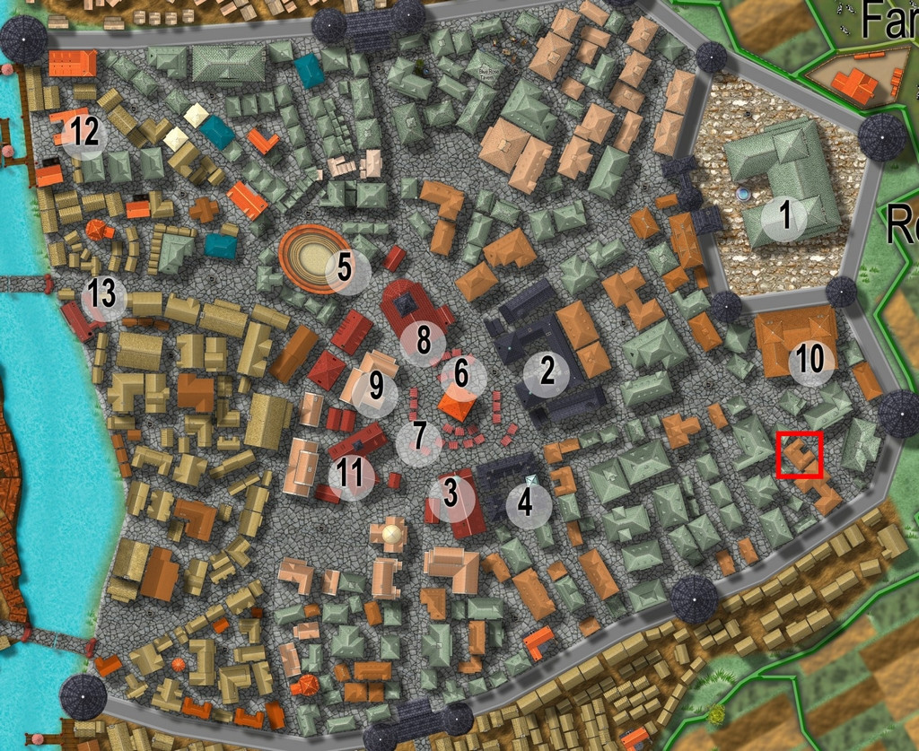
By the time I'd chosen a property to map the floorplans for from Vertshusen for this contest, I already had some ideas as to what it was going to be, and what mapping style I'd be going with. The chosen property is that marked by the red square in the SE corner of the walled area:
My initial thoughts had revolved around a haunted house theme, and because I've already done quite a bit of mapping for the Community Atlas using some of the more realistic floorplan styles, quickly decided I wanted to do something different. For me, part of the point in participating in the Atlas is to experiment with new ideas and different mapping styles.
Three possible styles were uppermost in mind, all very similar tech-drawing styles, the 1930s Travel Guide Floorplans from the April 2011 Cartographer's Annual, the 1800s Floorplans from April 2016, and the one I finally selected, the Dracula Dossier style from September 2015. Haunted house, after all!
However, I also took a look through the PDF of "Hobbs' Architecture", which was a recommended freely-available download from the Internet Archive site, mentioned in the mapping guide and webpage for the 1800s Floorplan style, to get a feel for what house layouts should look like and contain in this general type of map appearance.
The working title for the map was "The House That Wasn't There", as I had vague early ideas of creating a building that wasn't always there. Indeed, one initial concept had been to pick a completely empty space in the city, and map the house into that, only I couldn't find a space large enough!
Which building was chosen was partly down to something that looked interesting, that was also a little out of the way, and the final choice was swayed after I was drawn to one of the smaller buildings in "Hobbs'":
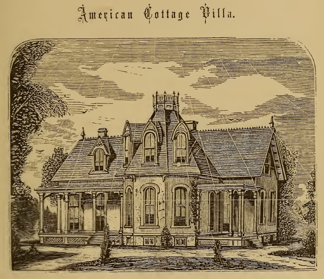
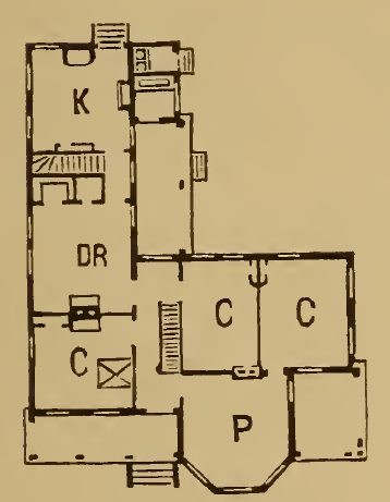
which just looked interesting, and had some features not dissimilar to the building in Vertshusen. The size and scaling weren't the same of course, as the Vertshusen buildings are uniformly tiny by contrast to the structures in "Hobbs'". It was a starting point though.
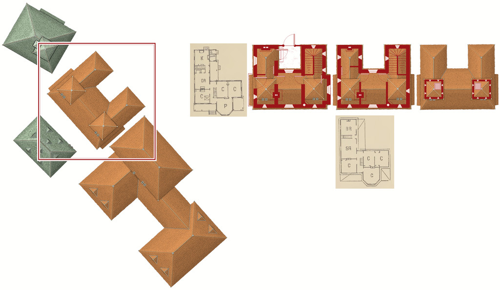
Having measured the house size on the Vertshusen FCW, I set up a suitable template in the Dracula Dossier style, and then directly imported (copy & pasted) the "Wasn't" House and its neighbouring properties, setting "my" house down in the centre of the map border area.
Of course, it's angled as originally drawn, and as others have commented in topics for this mapping contest already, that's not the friendliest layout for drawing rectilinear structures. So I copied the house again, and rotated it to better suit, and then copied that twice more (as my initial idea was for a ground floor plan, an upper floor plan, and a further plan for the two taller roof towers. I also imported copied scans from the Hobbs' book as reminders for the overall look of the plans, setting them up on their own Sheet with a Transparency Effect, so I could position them over the CD3 house roof and get a better idea of what might go where. And then started drawing. This illustrates where I'd got to with the drawings when I ran out of time yesterday:


-
Community Atlas: Queen Mica's Scintillant Palace
Which brings us round to the final South Wing, presented as just a single Level. More or less, anyway, as there are a couple of places where the tunnels pass over and under one another, which again helps give a slightly variant appearance to this map. This time, the base layout came from the DF video that actually launched the very first Burrows pieces, as part of their "Dungeons of Doom" KickStarter campaign in June 2017, "Encounter 14: Khri Colony". The Khri are DF's giant insectoid monsters that make such burrows, incidentally. The final amended layout is thus:
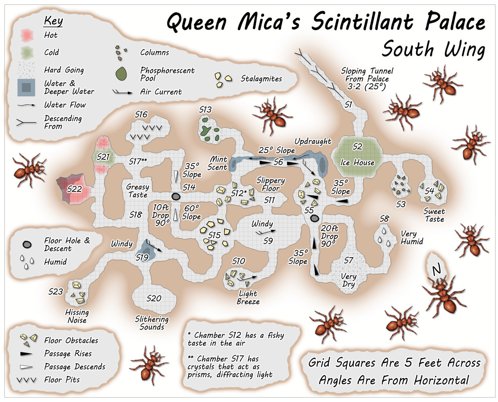
A lower height range seemed suitable for the southern side of the Palace complex, given how the surface view sketch was drawn.
So that concludes the extra maps to go with Errynor Map 40, and by the time you read this, I expect I'll be off mapping some far-flung corner of the region or other. Or is it ALL just an illusion...
![[Deleted User]](https://secure.gravatar.com/avatar/c75d9a245b74d9c59be0999ea81ca541/?default=https%3A%2F%2Fvanillicon.com%2F92add7f8c954488718110edc4896ad39_200.png&rating=g&size=200)


-
Community Atlas: Queen Mica's Scintillant Palace
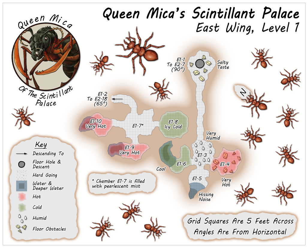
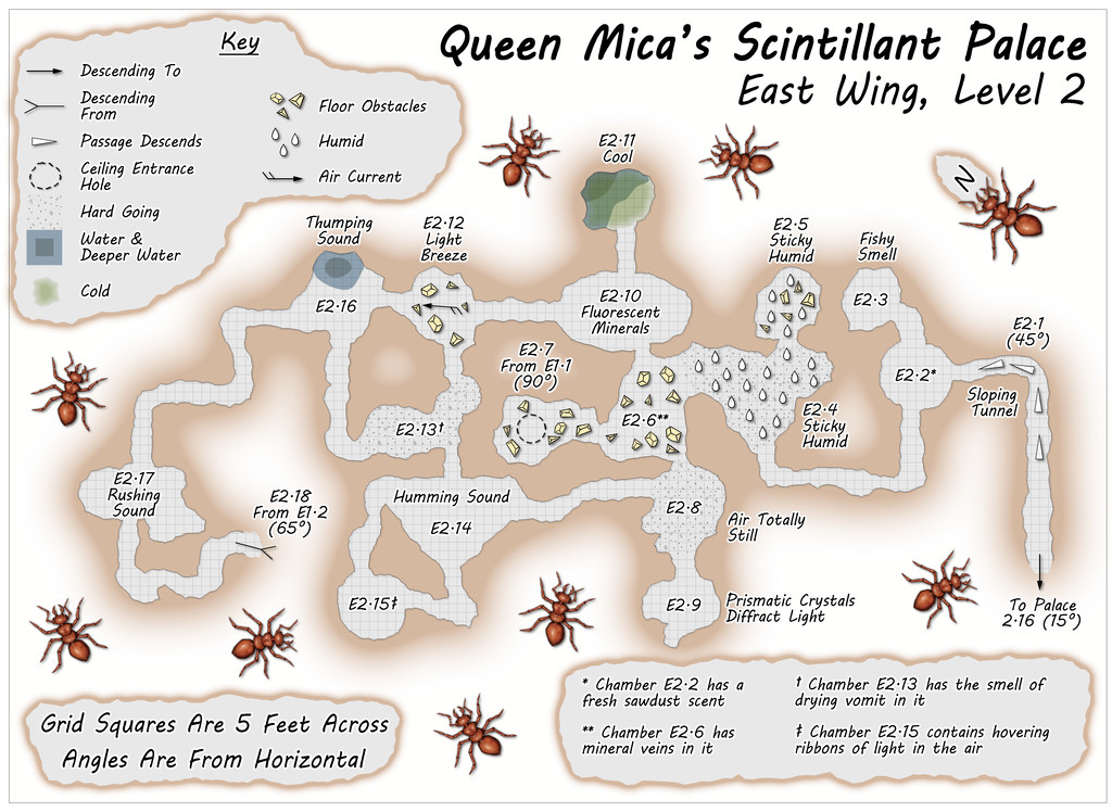
The East Wing runs to a mere two vertical Levels by contrast, based on images of a couple of layouts on the DF Discord, combined here with the usual additions and amendments, for all the final plans are much simpler than for either of the preceding pair of Wings, and clearly show their rectilinear original forms rather more. This was though quite deliberate, as part of the concept of the various Wings was to show differences between them, suggesting they could likely be put to different uses, and that this area was probably still largely under construction. Plus it wasn't only the layouts that had been getting figuratively tied in knots with some of the other maps!
Simplicity only counts for so much though, so the entryway from the Palace this time isn't on Level 1, but on the lower Level 2 (which is also a somewhat larger map than the others):
-
Community Atlas: Queen Mica's Scintillant Palace
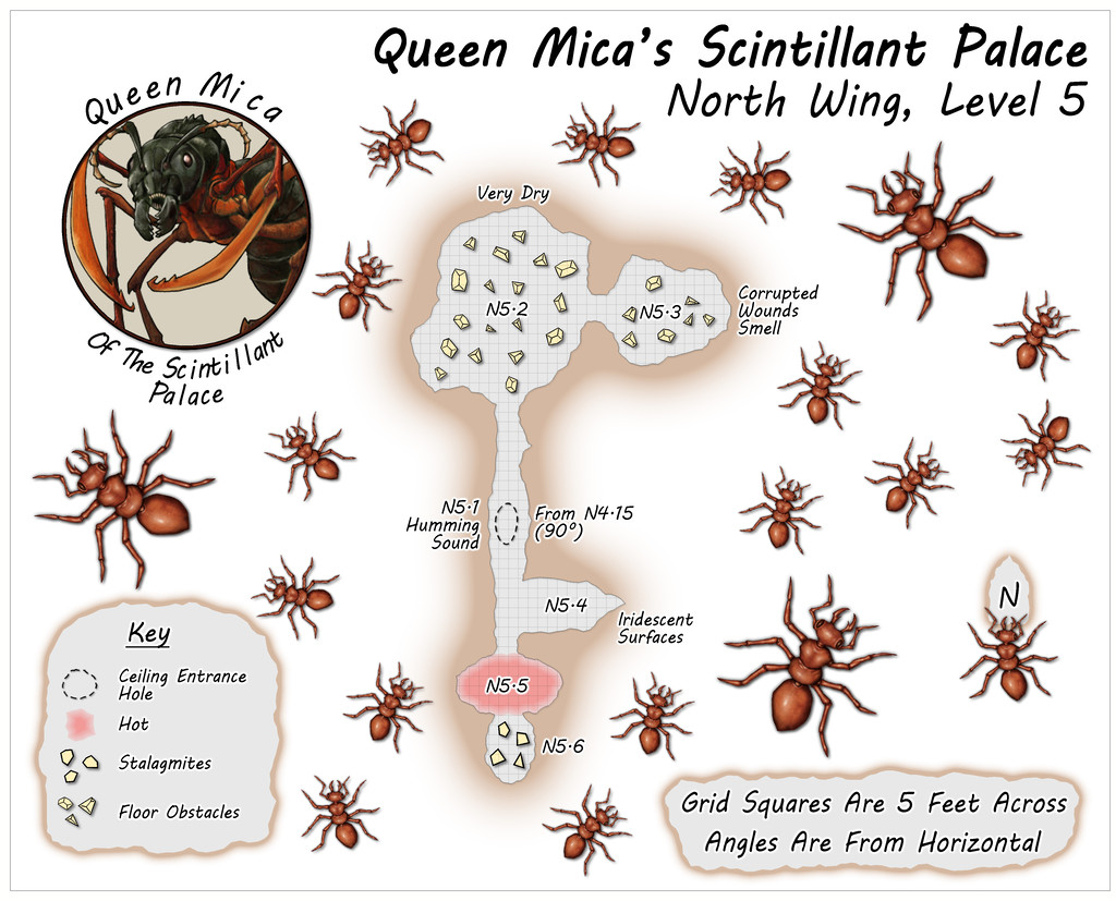
Circling clockwise from the West Wing, the North Wing is the most vertically-extensive of all the Wings, with five separate Levels, just like the central main Palace structure. The layouts here derived from a mixture of images on the Dwarven Forge Discord, and one of the official weekly "On The Anvil" livestreams on Twitch from January 2021 that featured another extensive Burrows build (go to 2h15m or so to see the final design). This combination led to an interestingly complex grouping of tunnels and chambers that, because of the way maps can be linked in the Community Atlas, meant both the small first two Levels were placed on the same map, as Level 1 here connects with both Levels 2 and 3, while Level 2 links back to 1 and on to 3 as well. This also resulted in a means of linking into Level 1 from the Palace by a tunnel that passes above the ceiling of two chambers on that Level, before dropping vertically into one of them. Thus, the North Wing:
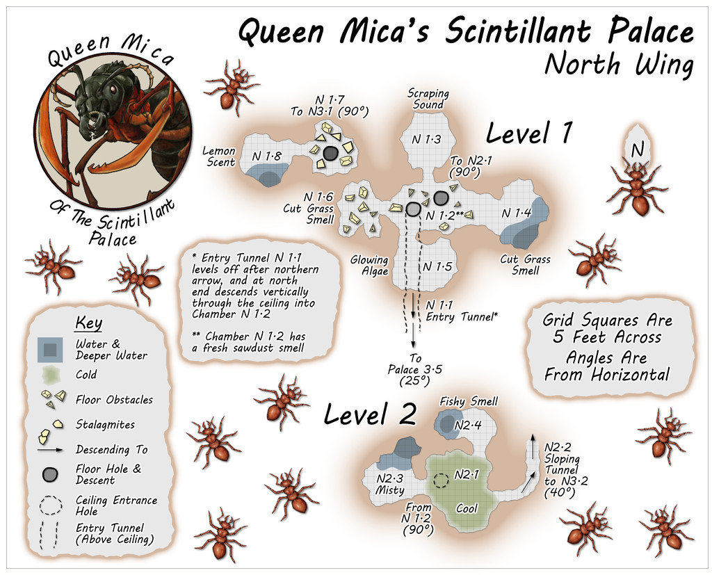
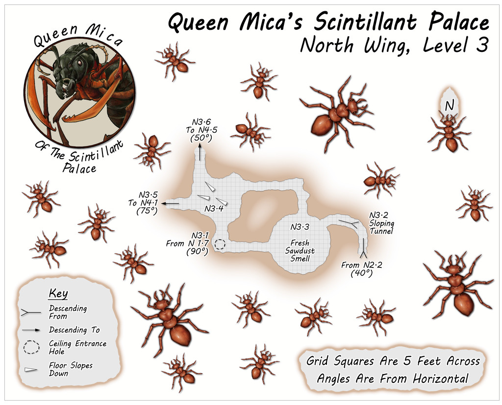
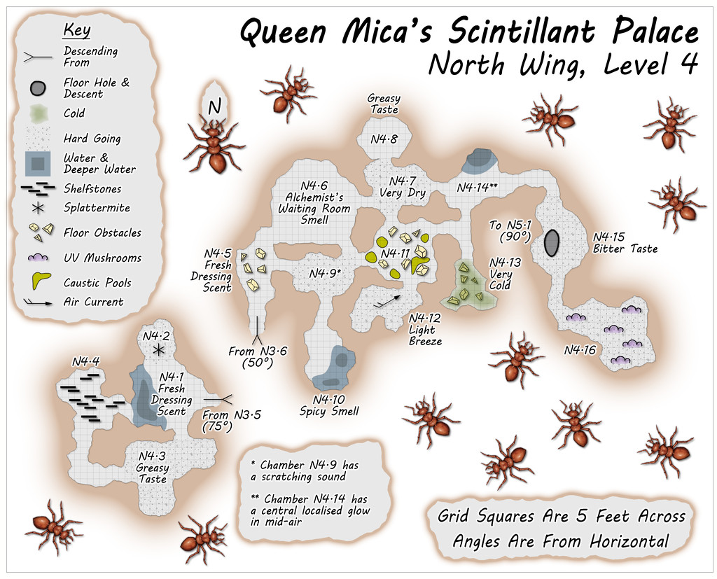
Some particularly unusual random items were rolled-up for Level 4, adding extra interest to this part of the colony beyond its verticality.
-
Community Atlas: Queen Mica's Scintillant Palace
As mentioned, the four Palace Wings were based on a different option than the "Carapace" booklet's system, hence none of these maps have schematic drawings beside them. Each was instead based on images posted by various people on the Dwarven Forge Discord, and from layouts shown in several official company videos available on the Dwarven Forge YouTube and Twitch channels. All used items from the cast modular terrain "Burrows" pieces made by the same company.
The nature of such modular terrain items does make for more rectilinear layout patterns than those generated by "Carapace", although this would make it possible to set-up layouts on the tabletop, for those owning such Burrows pieces, that are similar to what appears in the Palace Wing layouts overall. However, alterations were made to the sizes, shapes and orientations of the tunnels and chambers at times as shown in the final maps here and in the following posts, so exact matches would not be possible.
Despite this change, the nature of each chamber in the Wings was again randomly decided using the Appendix 2 tables in "Carapace", with occasional amendments, since these offer the potential for a number of interesting variations and features.
The selected layouts were combined and chosen to loosely match the look of the outlying parts of the Palace on the Illusory Level 1 map, meaning the layouts delving deeper were placed in the western and northern Wings, representing the parts of the surface sketch where the taller buildings and towers were.
First then, the West Wing, comprising three main vertical levels:
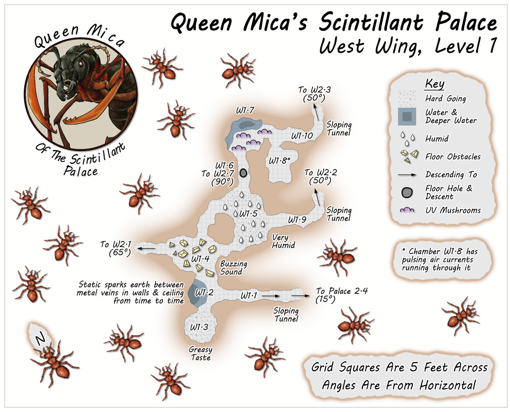
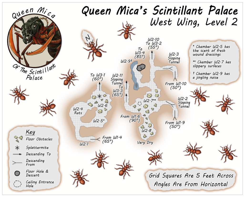
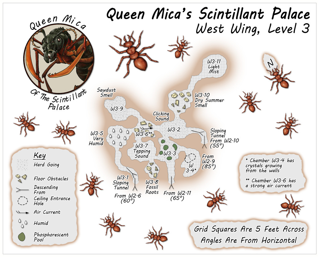
All the Wings have just a single connection to the outside, in each case by a link back to either Level 2 or 3 of the main Palace. In this Wing, that's on Level 1 of this trio, where Tunnel W1.1 leads back down to Chamber 2.4 on the Palace's second Level. This layout was based on the extensive, multi-level "Demonic Depths" Build of the Month video from May 2020 by Dwarven Forge.
The idea is that the Wings are generally less-used than the main Palace, so few of the areas in them have suggested-use labels on the maps (albeit some additional comments are provided in the accompanying separate notes files).

