


Wyvern
Wyvern
About
- Username
- Wyvern
- Joined
- Visits
- 3,238
- Last Active
- Roles
- Member
- Points
- 5,517
- Rank
- Cartographer
- Badges
- 24
Latest Images


-
Live Mapping: New City Style (Part 1)
I actually rather liked the look of the original map; there's a clarity to it that sometimes gets lost with the fancier non-vector styles. I may have made similar comments before though 😉😁!


-
Live Mapping: New Isometric Cities
Thinking about the late-stream discussion regarding using the "normal" Mike Schley city symbols to create a top-down map, and then the isometric ones to show a pictorial impression of the place on the same map, with Ralf's comment about using vignettes to highlight important individual places within the settlement similarly, brought to mind the Middle Earth poster map prepared by Pauline Baynes (Tolkien's only approved artist during his lifetime). Digging around online, I've come up with this reasonably high-res version of the original on the Museoteca website, which shows why it came to mind. I used to have a copy of the poster, sadly lost somewhere along the decades since, though it remains strong in my memory!


-
Community Atlas: Dendorlig Hall - A Sort-Of D23 Dungeon for Nibirum
Day 200 of 2023 seemed an apt moment for a fresh update on this project, so here we are, whole map first:
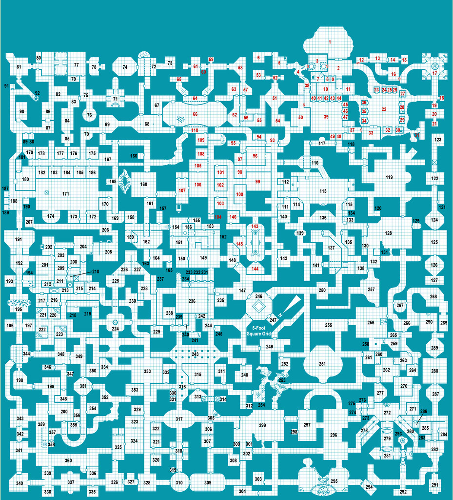
Further tweaking of labels and minor map features has proceeded apace since my late June update, and the type-up of my notes is in the early part of the University, area 259, currently, while the hand-scrawled preparatory notes are nearing the end of the Manufacturing District, area 293. Still a way from the area 360 end, but well up on the area 200 the day per area idea might have indicated otherwise 😁. (And yes, I STILL haven't got round to adding a symbol key or map title...)
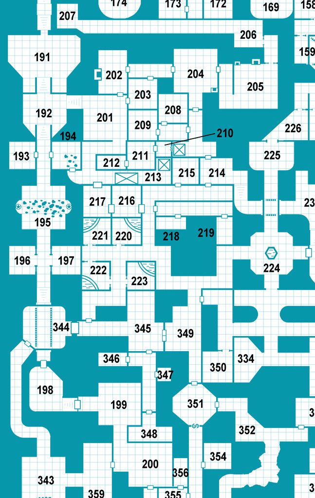
For today's closer look, following last month's minor temptational mention, we have the extracted PDF notes for the less-well-off living areas of the Hall in The Dell, areas 191-224:
All being well, still more to follow!
Meanwhile elsewhere, most folks I'm aware of who were trying the D23 project seem to have been struggling to continue it of late. Some recent discussions on one of my more active Discords, where D23 was A Thing earlier, have indicated no one there's still persisting unfortunately, although a couple of folks on a separate Discord server were still posting occasional updates into early July at least. Certainly, having the base map and ideas for every area randomly generated in advance, as I did, seems to have helped keep my attention focused at least, so that might be a way to go for anyone contemplating something similar later this year or next, or on a smaller scale, for instance.


-
Live Mapping: Hilltop Fort 1
Must admit, I was getting slight déjà vu feelings watching Ralf's livestream yesterday, as parts of it reminded me of my Wyvern Citadel maps for the Community Atlas. Very different scale of course, but there are inevitable similarities for drawing anything set on a craggy hilltop in this kind of more realistic style.
I made much more use of symbols however, rather than drawn polygons, for the cliffsides, though I did experiment that way originally (see this post in my Forum notes on the Citadel map, while still in progress). Just couldn't get the bevelled polygons to look right though, so switched to a technique developed for battlemat cliffs by another of our resident mapping experts, Shessar, as described via the Forum post here. As ever with CC3 mapping, there are always different methods to try!
Looking forward to Part 2 of this video, to see how it all develops. Anyone would think Ralf was running a game set in Middle Earth...😉
-
Community Atlas: Dendorlig Hall - A Sort-Of D23 Dungeon for Nibirum
Well, this comes after a rather longer gap than I'd expected! However, progress has been continuing with this map throughout, if at a slower and much more intermittent pace than previously. Unsurprisingly, six months after the start, quite a number of folks who embarked on the D23 concept in January are either also finding problems and delays, or have abandoned the project entirely, so some ongoing progress is a positive note at least.
My scrawled notes have now got up to area 271, although getting them typed-up has slipped back further, as I'm currently only up to starting area 211 with those. It is, of course, always much easier to add a few jottings to a piece of paper in a few spare minutes than to have to set up the wpc on the computer, type, check and correct stuff that can be deciphered from said handwritten notes, often written many weeks earlier!
The map continues to receive small changes, and at some point I really must remember to add a key and a title to it... However, in honour of this Solstice update, let's start with an overview of the current state of the entire map:
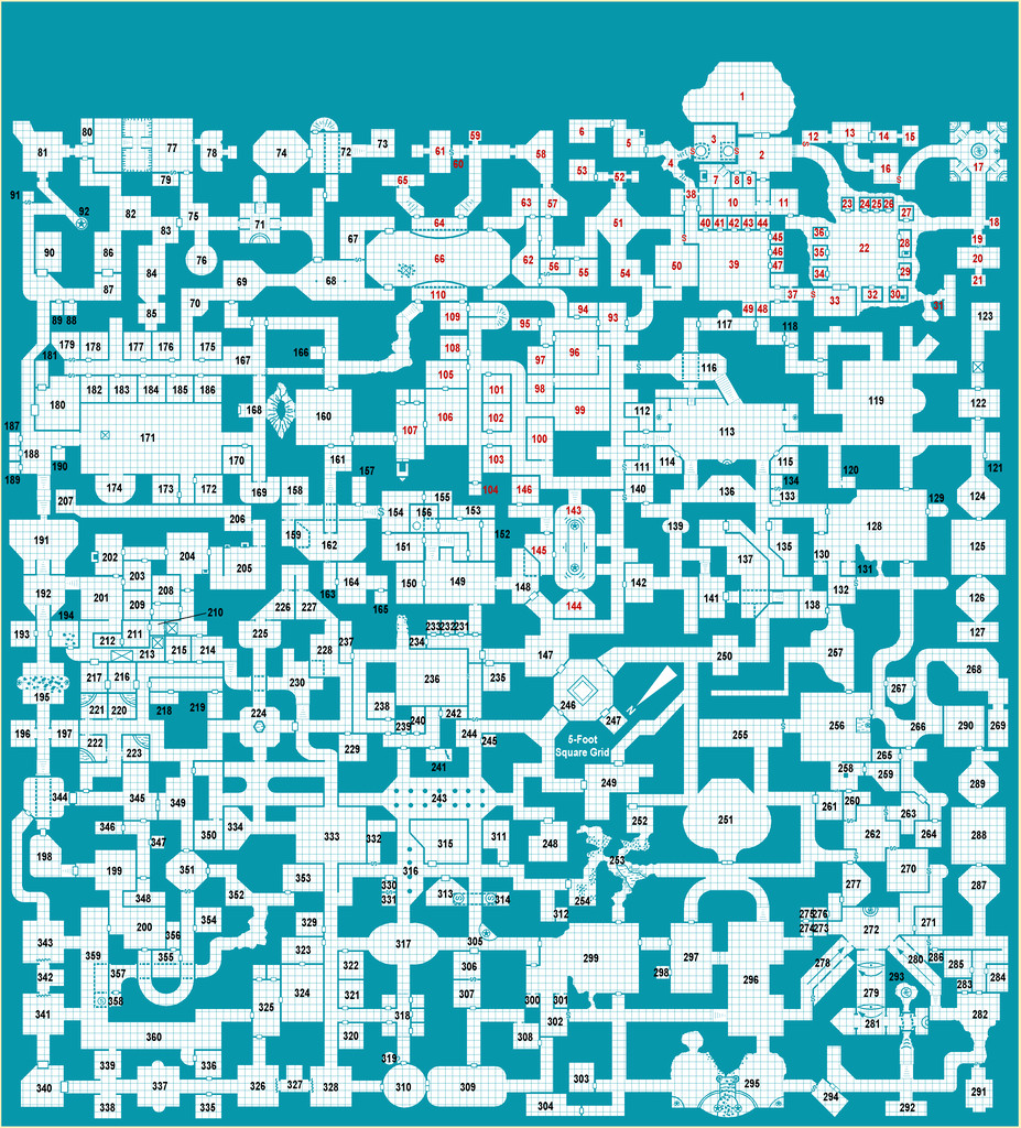
From which it's clear that tweaking of label placement continues, along with amendments to the appearance of the map, albeit for the labelling, only in areas for which the type-up has been completed still. The enlarged numerals, while now easier to read overall (at a higher-res than is suitable for the Forum, at least), have needed moving off their rooms entirely at times for clarity of map details. Area 210 has even had to have an indicator line added, so things still look OK on that bit of the map. That's the hidden entrance room to the old Thieves' Guild, also known as Toad Hall, incidentally. You'll have to wait to find out why though, as for today's closer examination, I thought we'd head into the more upmarket part of the Hall (or what was, when it was still occupied, at least), Khy Row (167-190):
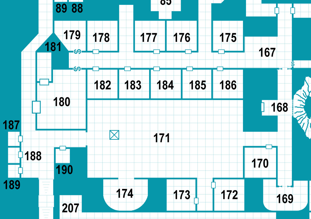
Why Khy Row? Well... When I was looking over the randomly-appointed features for the various rooms here, I thought one should be a bazaar. So it became the Old Bazaar (170); and for those who may not know, or recall, there was an old British Music Hall style song, "In the Old Bazaar in Cairo" 😁.
For those undeterred by such awfulness, 😉, these are the PDF notes extracted from the full document just for this part of the Hall:
Hopefully not quite so long a delay for the next update, though after what's happened lately, I make no promises!
