


Wyvern
Wyvern
About
- Username
- Wyvern
- Joined
- Visits
- 3,238
- Last Active
- Roles
- Member
- Points
- 5,517
- Rank
- Cartographer
- Badges
- 24
Latest Images


-
Community Atlas: Monseignor District in Kentoria
As I noted after completing my Dendorlig Hall project last October, I'd hoped to have returned to my Alarius mapping by now. Other matters intervened however, and are liable to persist through at least the first quarter of this year too, so I thought it worth trying some smaller mapping projects for a while instead. Partly, this came about following discussions with a few folks on a Discord regarding what to do about possibly continuing with the Dungeon23 concept this year, given almost no one had persisted all year with that, and few had accomplished anything like what they'd hoped for it.
The concept I have for myself currently is to try to map a small dungeon or area each week or so, which, although probably impractical in the long-term, does provide a focus of sorts. Those I complete will all go into the Community Atlas, and following my normal preference for some element of randomness about such Atlas creations, I decided to use the Inkwell Ideas dice sets to generate the base maps in all cases.
For those unfamiliar, the Inkwell dice sets are packs of themed, over-sized, six-sided dice (D6s), where each face has on it a different geomorphic dungeon or cavern drawing. The packs contain either five, six or eight such D6s, and there are currently 12 packs available, three of which are overground settings, nominally "Villages", "Cities" and "Ruins", although the "Ruins" dice are duplicates of the "Cities" ones, where parts of the design have been wholly or partly destroyed. Twelve packs, you say 😁? As in months in a year...
By using random numbers, and selections, of dice from each set, I've generated 52 individual hand-drawn maps based on what the dice provided, which designs were then randomly allocated to places on Nibirum for which regional maps existed in the version of the Atlas I'd most recently downloaded, albeit from earlier last year. The ultimate placements for almost none have been finalised yet, as I'm opting to identify specific locations for them only as I'm progressing. So far, things may turn out to be more complex than I'd hoped, as it may be additional smaller area maps will be needed for many of these along the way too, to define more exactly where they are.
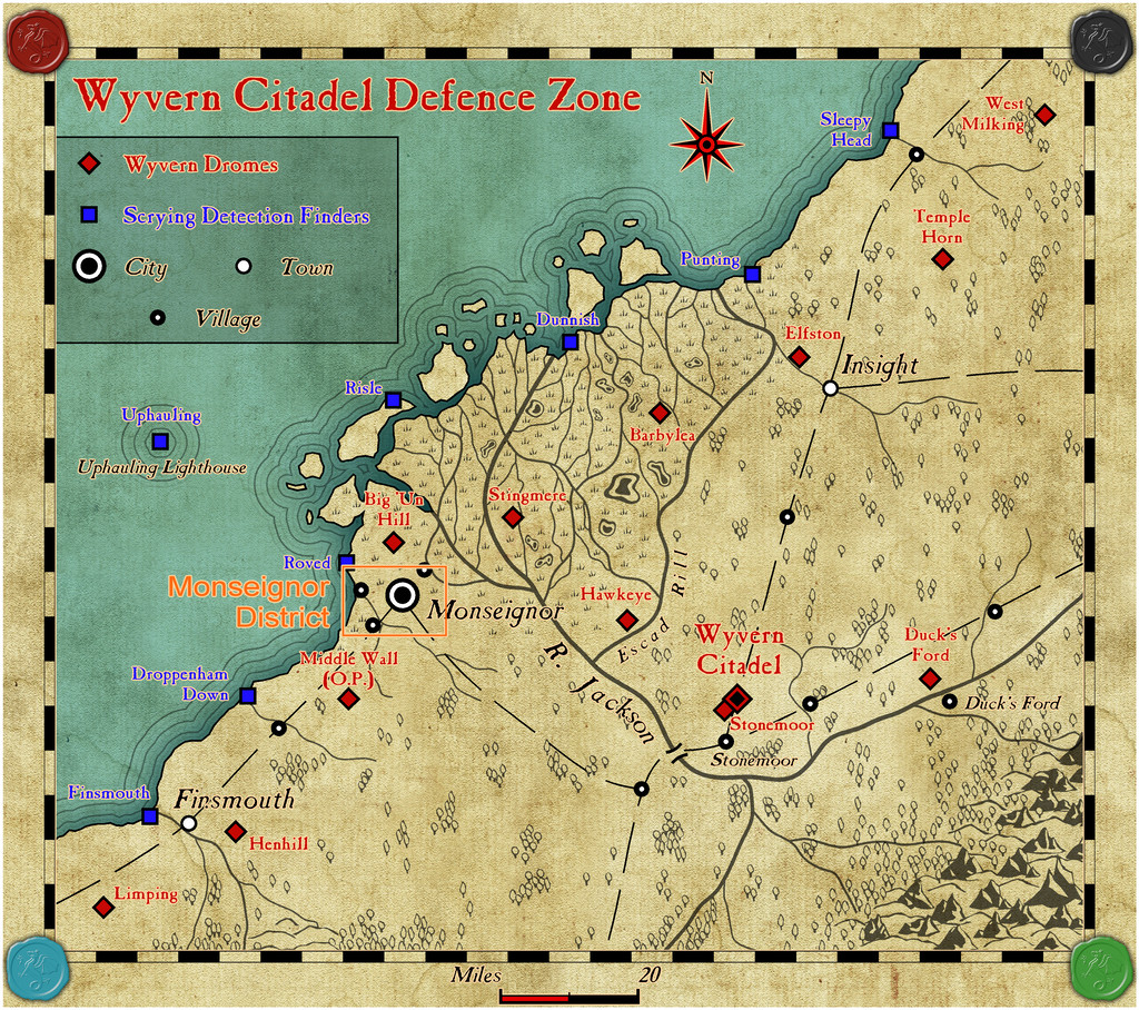
However, the first small map and its new area map are complete, and have been submitted for the Atlas, having oddly enough landed by-chance right into one of my own area maps, the Wyvern Citadel Defence Zone on Kentoria!
Although actually prepared in order of dungeon first, then overground, when going into the Atlas, this situation of course is reversed, so the general area the dungeon was to end up in has first to be identified, what became the Monseignor District map, whose placement was to be here:
That area now looks like this, in more detail:
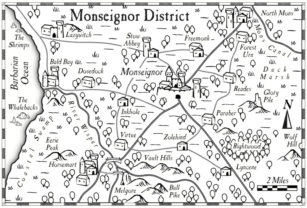
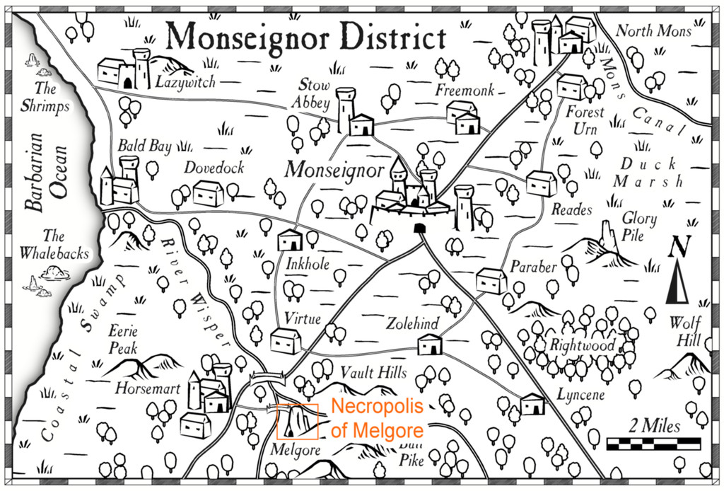
Or at least it does using the Overland Black & White style from Annual 20. Most features had already appeared in the earlier larger area map, or its description, although now some semi-random names and features could be added to those previously unnamed and not shown. Plus of course, the location of the dungeon map had to be provided as well, at Melgore:


-
Sinister Sewers - Style Development Thread (CA207)
@thehawk makes a good point about ancient sewer systems. I think the earliest definite sewer pipes date to around 4000 BCE in what's now southern Iraq, at the ancient cities of Eshnunna and Uruk, although more sophisticated sewer systems survive archaeologically from the Indus Valley civilization around a millennium later (c. 2300-1800 BCE). Most were of brick or clay construction in various forms.

-
Community Atlas: Dendorlig Hall - A Sort-Of D23 Dungeon for Nibirum
So, as promised, the final submission version of the map is now completed, as of Day 280 of 2023 (i.e. yesterday!). And here it is:
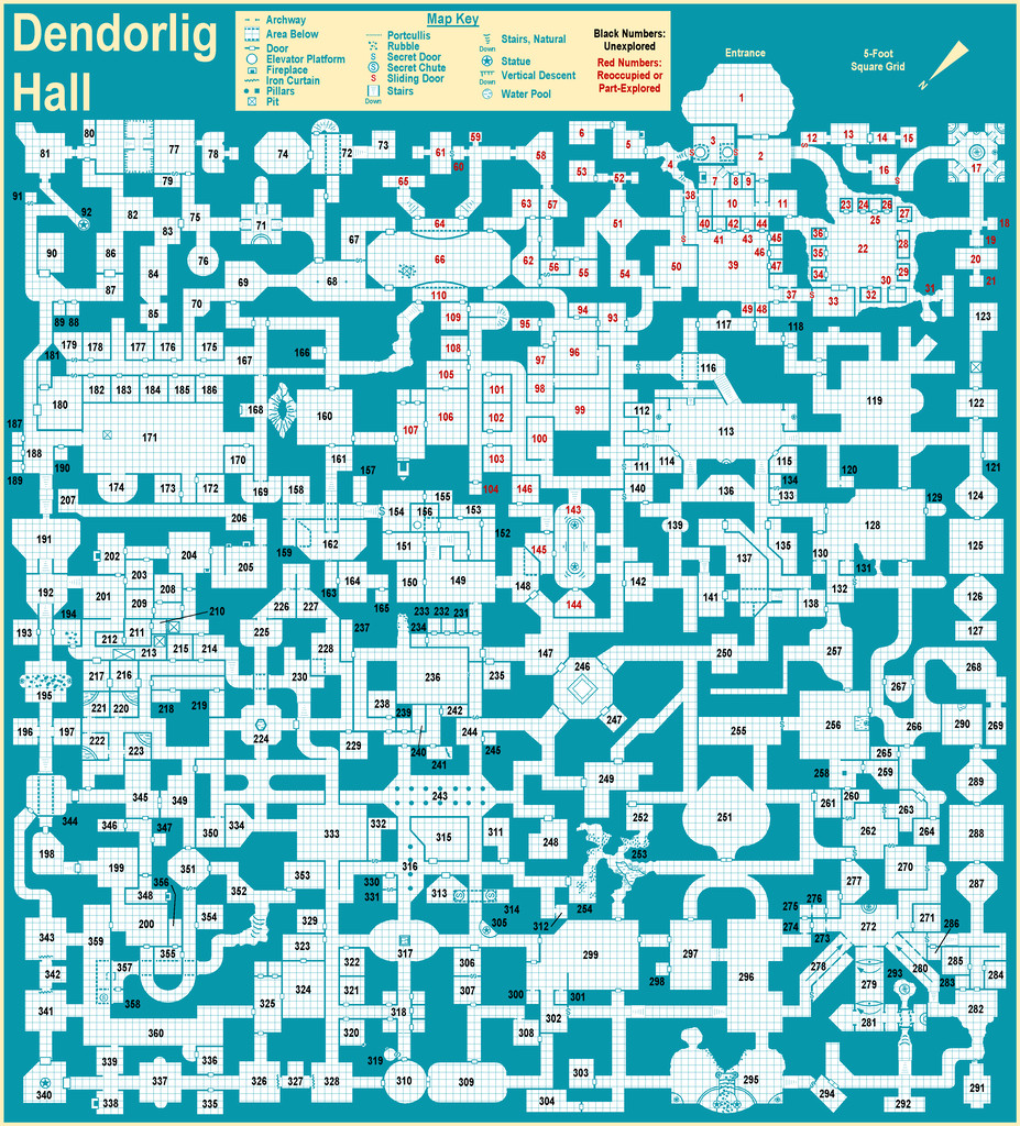
You may not notice any difference from the Day 250 version posted last time, and I'm not sure there actually is one, at least not that would be obvious at this resolution. However, behind the scenes there have been substantial changes, as following discussions with Remy ahead of submitting the map for the Atlas, I've added descriptions as CC3+ map notes for each individual area, as hotspots tied to each number on the map, and which will thus be available in the FCW version of the Atlas map. The complete set of texts for all these, and the general map notes, will also be provided as a single PDF file, as normal.
This particular mapping style is very straightforward to use, and as noted earlier, is also a very forgiving one, which uses no sheet effects. Thus it wasn't a strong challenge to map with, for all that was an interesting experience in itself. However, adding the map notes and hotspots to the map was something I've never tried before, and that proved a useful exercise in expanding my CC3+ experience. It was a great deal more straightforward, and quicker to complete, than I'd anticipated too, which was a pleasant surprise. [This is the point where Remy admonishes me for getting some key part of the exercise wrong, of course...]
I'd never really considered adding notes to my maps electronically, since I normally only use printout versions of them, and while that's unlikely to change, this would be something I'd consider for the Atlas in future now, where the map's suitable for such, having tried it out. Which of course was part of the point in my taking part in mapping for the Atlas, to let me explore elements of the program new to me!
Time to return to my Alarius mapping now though. Although it's possible there might be a further distraction before then...


-
Does CC3+ support webm and webp file types?
Reawakening this topic as over the weekend I discovered a recent change to the basic Windows image viewer software, "Photos", means it will now convert webp images to other forms of image, including various bitmaps, such as jpg. You simply use the "Edit" facility and save it how you require from there. There've been a number of other changes to Photos in recent months, but this one is actually useful 😉!
-
Community Atlas: Dendorlig Hall - A Sort-Of D23 Dungeon for Nibirum
Slightly later than I'd hoped for the eighth main update on this map, although Day 250 of 2023 seems an apt moment to present it at least, particularly as just this morning, I completed the draft notes for area 360, the final one in this mapping project! Getting those notes typed-up still lags some way behind (at area 310), so the map and notes won't be going into the Atlas right away. The end is in sight, however!
While there may be (hopefully only minor) changes needed to the map after this, during checking of the text, or as other things occur, this is likely to be close to the final version now:
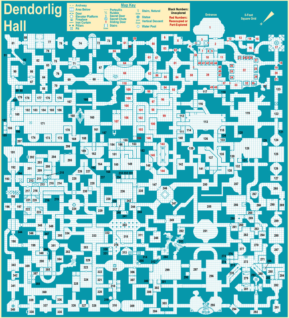
From this, it's clear I finally got round to adding the title and a key for the more recurrent mapped elements, and also moved the North pointer and scaling note off the map entirely. I decided too to make the colouring of the title and header labels a pale cream, the same pale cream this style uses for its drawing window background, and which, in preparing the map for the Forum, I've also used as a thin "map border" of sorts. This header-colouring usage helps draw my eye (at least) into the map, making clear which items are peripheral to the map itself.
I've not prepared any additional close-up map or PDF notes to add here today, since the final version will be ready relatively soon anyway, although I have updated my Gallery image for this map now, to a higher res version of this near-final one.
All being well, the next update should be the Atlas submission one!


