Monsen
Monsen
About
- Username
- Monsen
- Joined
- Visits
- 660
- Last Active
- Roles
- Administrator
- Points
- 8,858
- Birthday
- May 14, 1976
- Location
- Bergen, Norway
- Website
- https://atlas.monsen.cc
- Real Name
- Remy Monsen
- Rank
- Cartographer
- Badges
- 27
Latest Images


-
Viewer link broken
The viewer was discontinued a while back. Because most maps in modern CC3+ are based on raster artwork requiring external art files, the viewer wasn't able to display those maps without also having the same artwork available, so it no longer had the utility it used to have.
If you wish to let non-CC3+ users see your maps, I recommend just exporting them to an image or printing them to a pdf file, this is the best ways for people to see them without having to own all the artwork used.


-
Crash when trying to add grid on Annual Retro Starship (Metric) map
Looks like there is a corruption with one of the grids.
Try this:
- Save the map
- Delete all the grids one by one (You won't be able to delete the standard XXX ones)
- Close the dialog
- Save the map
- Now try adding the grids you need one by one. I recommend saving the map after each.

-
CC3+ and CPUs
For CC3+, there will not be much of a difference between those two. A lot of operations in CC3+ are single threaded, in which those two score pretty much the same (but about 50% better than your old one).
Some processes, like some effects do take advantage of multiple cores, but it is unlikely to fully saturate your CPU, so even if the 7700 is better, I doubt you would observe much difference between them. But the 7700 do have two extra cores that can work on other things the same time as CC3+ works though, which can be an advantage.

-
Struggling to select an area to work on.....
There is a blog article here:
Since you mention the hex grid, while it certainly is possible to transfer suing the same process, I recommend just dropping it and creating a new one. You'll normally want smaller hexes anyway for your detailed area map.
Here's also a video with Ralf explaining the process.
vthumb(EXQYu2ayFTc|Live Mapping: Regional Zoom)
-
Please help with hex map scales...
Also, how do I know how big the hex is? Do I measure edge to edge? Top to bottom?
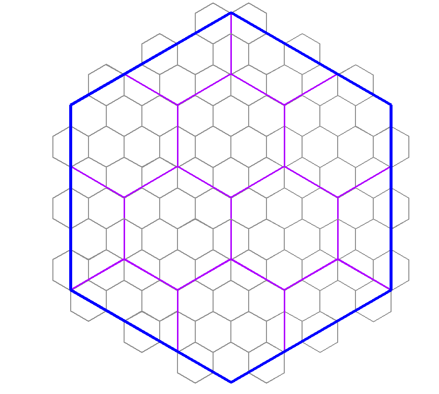
In CC3+, the size of the hex is measured edge to edge. (For a horizontal hex grid, that would be the same as top to bottom, since edges are at the top and bottom). [This means that the corner to corner size will be 1,15 times larger than the specified hex size]
The scale really depends on how detailed you want your world. Hex mapping, by it's nature, do make the detail level a bit simpler for a map. Hexes are also a bit problematic when you want different sizes, because you can't easily line up hexes inside a hex like you can with squares. But the best number is if you use a difference in scale that is a multiple of 3. (As such, your example of using 6 miles, then 24 miles doesn't work too well, because 24 is 4 times 6, and 4 is not a multiple of 3). As long as you use a multiple of 3, you should be able to have a tiling that only includes full and half hexes, as per my diagram below, and corners will line up with each other. (so 6 and 36 would be appropriate values for the two scales in your example)
As for the whole world scale, just continue multiplying by numbers that are a multiple of 3 and establish a size that feels comfortable for you. Generally, I would be very of any size that leaves more than a 100 hexes in any direction, but if you use 36 for regional areas, you could consider 216 for continents and 648 for world size. Those sizes would line up nicely with each other.
But, then there is the big question, do you even need them to line up properly like this? If you map each map individually, then you might not ever have the larger hexes of the regional map be a factor at all when making local maps. Sometimes, the value of having hexes of nice round sizes can be much more beneficial for the current map. Hexes for the main map could be 250 or 500 miles, continents could be 100 miles, regional ares 25 miles, etc. Unless the maps are going to be directly overlaid each other, you probably aren't actually going to need hexes that lines up with bigger scale maps. But of course, this is up to your own needs and desires.