Royal Scribe
Royal Scribe
About
- Username
- Royal Scribe
- Joined
- Visits
- 9,539
- Last Active
- Roles
- Member
- Points
- 3,353
- Birthday
- February 5, 1968
- Location
- San Francisco, California
- Website
- https://legacy.drivethrurpg.com/browse/pub/31814/Royal-Scribe-Imaginarium
- Real Name
- Kevin
- Rank
- Mapmaker
- Badges
- 16
Latest Images


Reactions
-
Sticky Note Dungeon
Tremendous work -- and C.C.'s second annual this year!

-
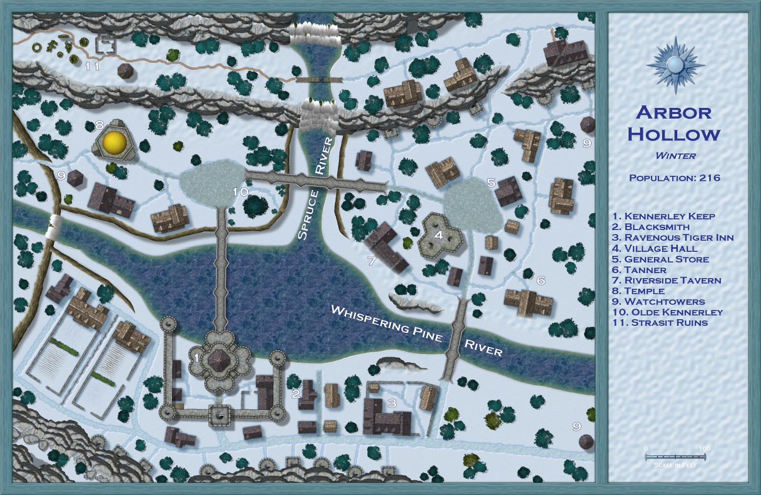
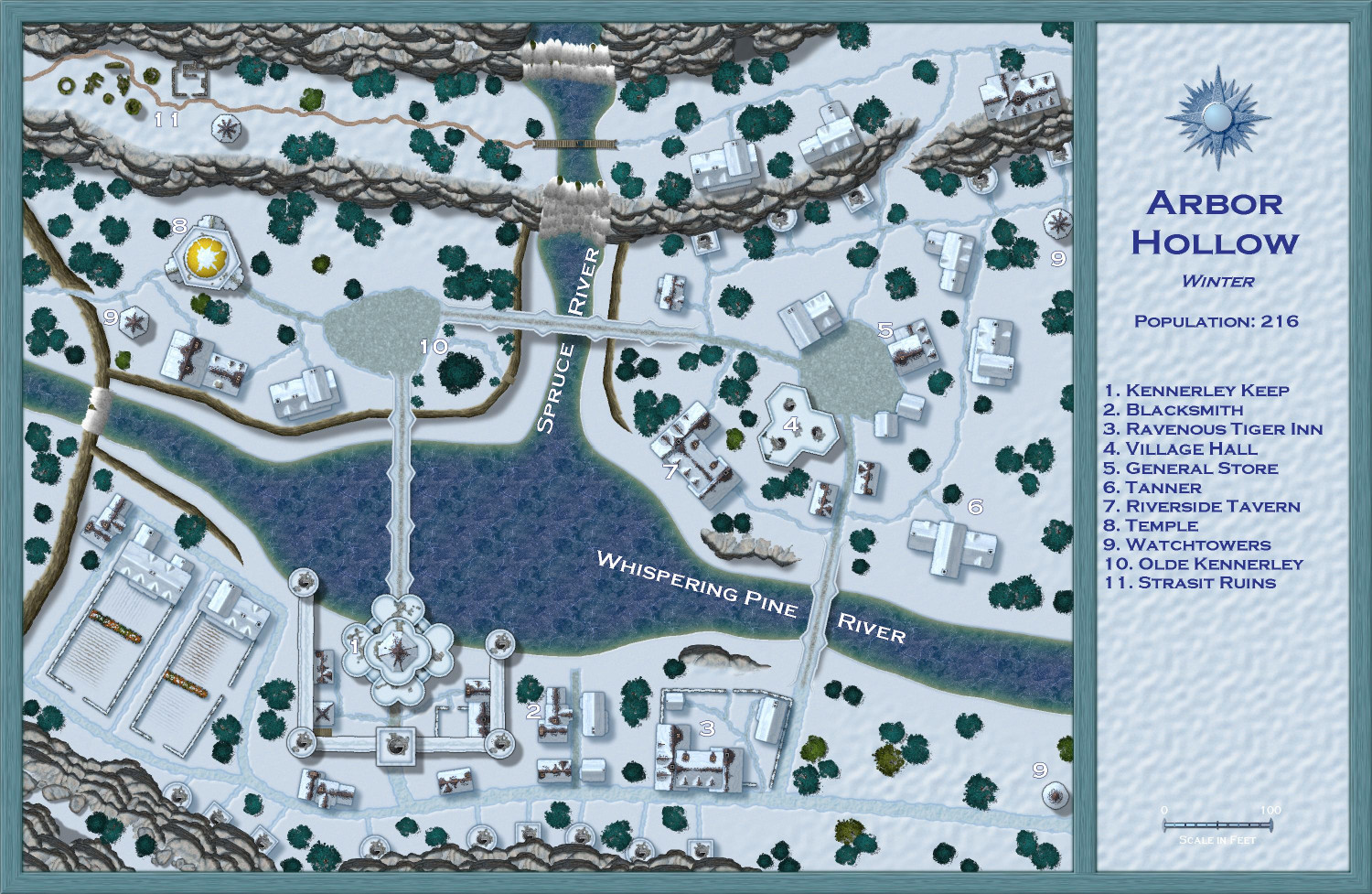
[WIP] Atlas Contest (potentially) - Arbor Hollow (summer, autumn, winter, spring)
Okay, trees converted. This was trickier than expected because these ones tended to be a little jumpy wumpy when I replaced them.
Currently debating what to do:
- I could go through and move the trees that did something weird, like jumped onto a road or building, and move them, knowing that their final placement won't be exactly the same as the summer map it's derived from. or
- Roll back to a backup FCW (fortunately, I've been making backups before every significant change in case something went wrong), and then replace each tree individually.
I'm leaning towards #2. It might be weird cycling through each of the seasonal maps with the trees in an identical spot for three of them and then suddenly jumping around for the fourth. And while it may seem tedious to go through that process, tree by tree, I'm actually finding it kind of peaceful.
But either way, it won't be finished tonight. Fortunately, this winter map was never intended for the competition and I've already gotten my contest maps submitted.
-
[WIP] Atlas Contest (potentially) - Arbor Hollow (summer, autumn, winter, spring)
Making progress on the symbols from Forest Trail. Cliff and river bank symbols have been swapped out for their snowy counterparts. Same with the ruins symbols, and the wooden bridge. Changed the trail on the western side of the wooden bridge to use the Forest Trail effects. Added breaks in the ice for the Spruce River, and as it continues down the Whispering Pines River.
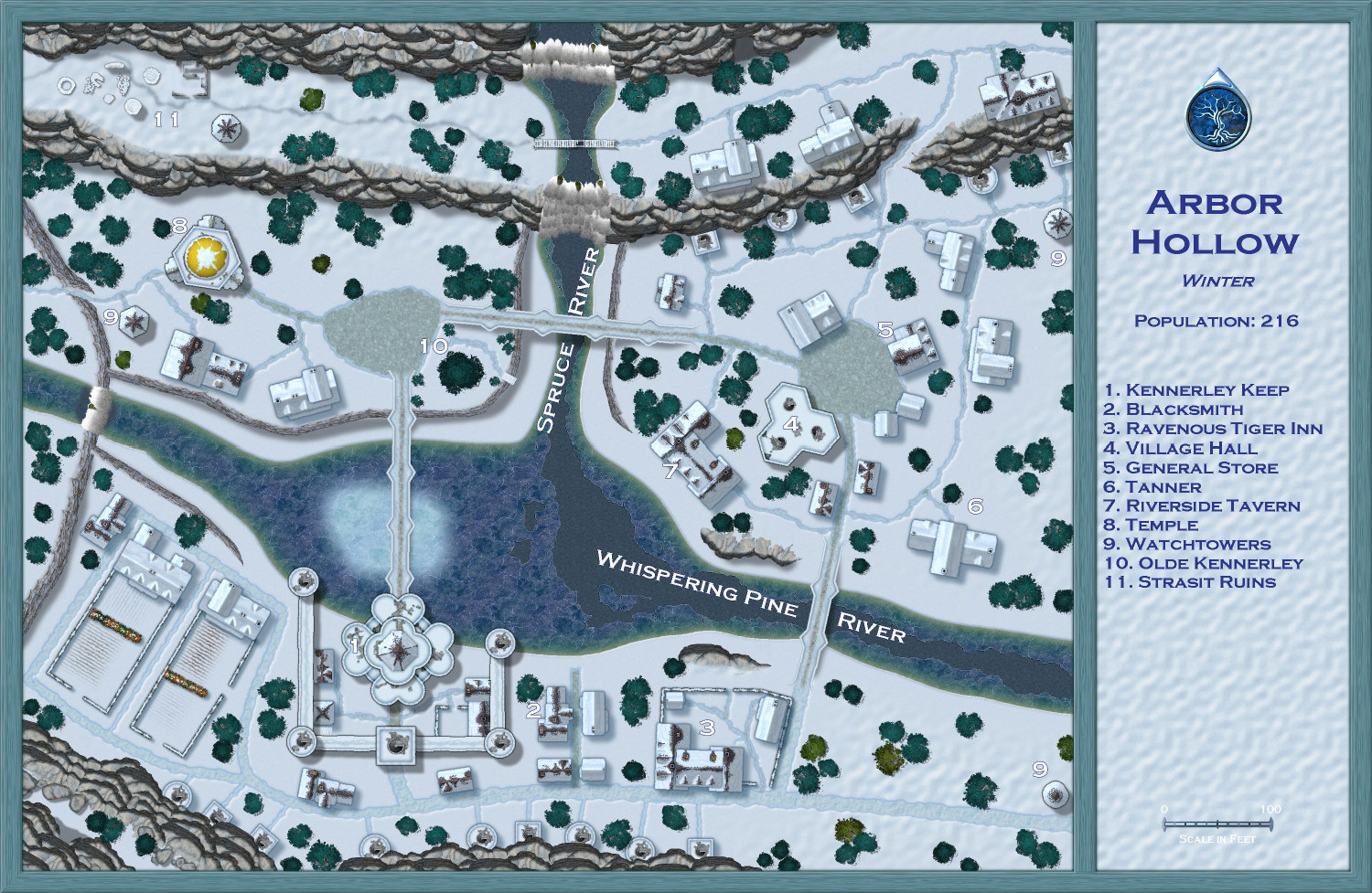
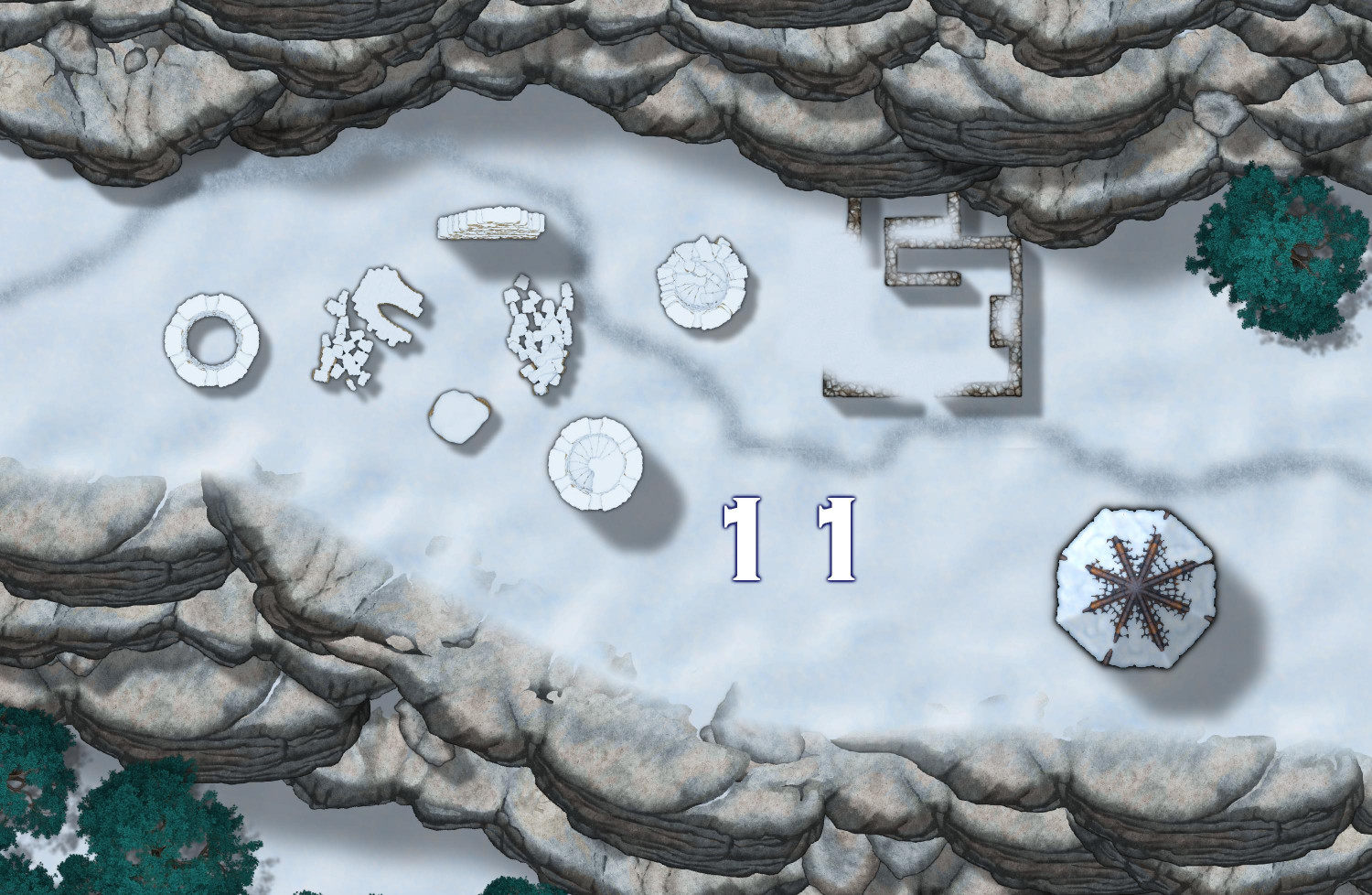
For the ruins, there wasn't a snow-covered version that I saw. I thought about covering it entirely with a hill of snow, but discovered that I could make frosty patches using the "Terrain Default Cliffs Drifts" drawing tool, which I will also use (on separate sheets) to add a little snow to the rocky outcrops. This is how it looks on the ruins close-up:
Not sure I like the frost on the upper part of Whispering Pines River. Not sure if I should expand it, so it covers more of the iced-over part, or reduce/eliminate it.
Still need to swap out the trees and add snow to the outcrops.

-
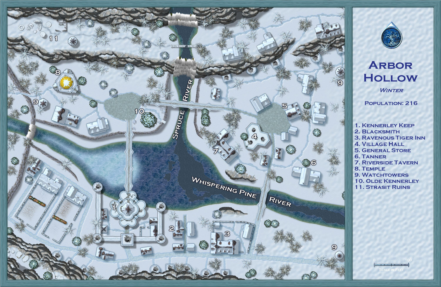
[WIP] Atlas Contest (potentially) - Arbor Hollow (summer, autumn, winter, spring)
Making progress!
I think all of the Darkland City symbols (tile and thatch buildings, walls, towers, stone bridges, hedges) have been replaced with their snow-covered Winter Village equivalents. The one thing that I don't think Winter Village has are the stone outcrops (Sue, please point me in the right direction if I've missed them), but that's okay: I have ideas for how to add little patches of snow to the outcrops. I also don't think there's a snow-covered equivalent for the derelict versions of the Darkland City buildings, so the one derelict tower I used (over in the ruins at #11) was replaced with a regular snow-covered tower.
One thing I noticed: when I used the Symbol Manager to swap out symbols, sometimes the replaced symbol was slightly off. In two instances, buildings were replaced with a 90 degree rotation from what I had, and in a number of instances, the buildings had been moved either on top of or too far off from the roads. I found it easiest to make one replacement and then check the map to move the placements if necessary before moving onto the next replacement. Slow and steady! Still better to do it this way than to manually delete and replace each individual symbol. Please let me know if you see anything that looks like it needs to be adjusted.
Still to come: replacing Forest Trail symbols (earth cliffs, deciduous and coniferous trees, ruins, rocks) with their Winter Trail snow-covered equivalents. And then adding breaks and cracks to parts of the rivers, and frost to the others. I had an idea for making ice skating tracks over the frost-covered parts of the frozen river. We'll see if I can pull that off.


-
[WIP] Atlas Contest (potentially) - Arbor Hollow (summer, autumn, winter, spring)
Here is Winter so far. Still tons to do, but I've managed to get everything on their correct sheets, I think, and the imported sheets in the correct order. Converted the rivers to the iced-over versions. I will add breaks and cracks from Winter Trails later to the Spruce River and the lower part of Whispering Pines River, and then frost to the upper part of Whispering Pines River. Converted the paved roads to the default winter roads, and the dirt ones to the winter muddy roads. (You'll notice that one path at the ruins in #11 hasn't been converted yet. When I start to bring in style features from Winter Trails, I will make that into a path or maybe footsteps. Converted the crops to snow-covered counterparts. But the biggest changes are yet to come: swapping out the building, tree, and other symbols for their winter counterparts. I will have to look at the sample maps with the annual to get ideas for how to better display the label numbers.