


Royal Scribe
Royal Scribe
About
- Username
- Royal Scribe
- Joined
- Visits
- 9,538
- Last Active
- Roles
- Member
- Points
- 3,353
- Birthday
- February 5, 1968
- Location
- San Francisco, California
- Website
- https://legacy.drivethrurpg.com/browse/pub/31814/Royal-Scribe-Imaginarium
- Real Name
- Kevin
- Rank
- Mapmaker
- Badges
- 16
Latest Images


Reactions
-
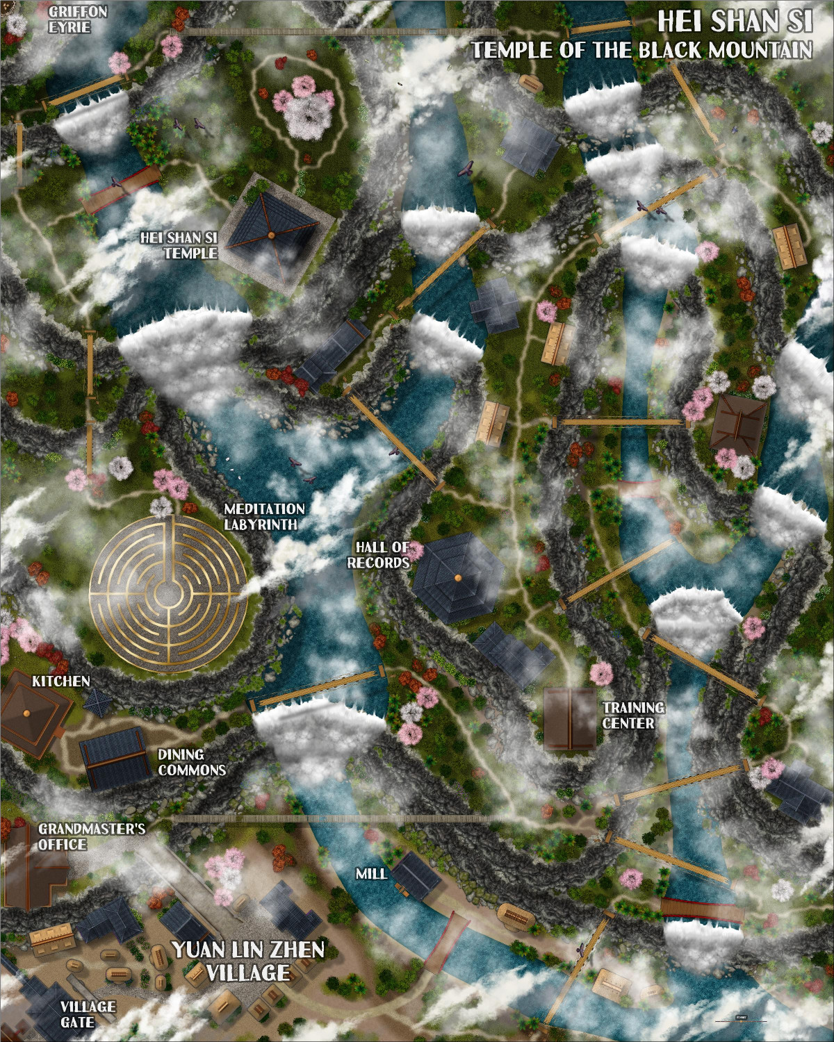
[WIP] Community Atlas: Kumarikandam - SE Tiantang Region
Oh, apologies! Can you use this FCW instead? There's one more toggle:
TOGGLE: "SHADOWS" layer to reveal/hide cliff shadows.


-
[WIP] Community Atlas: Kumarikandam - SE Tiantang Region
Here is the second of three monasteries I am mapping with Ricko. The description, written by Ricko, follows below.
The Sacred Path of Hei Shan Si
Toggle: CLOUDS layer to reveal/hide clouds
Toggle: VEGETATION - TREE CANOPY layer to reveal/hide the treetops
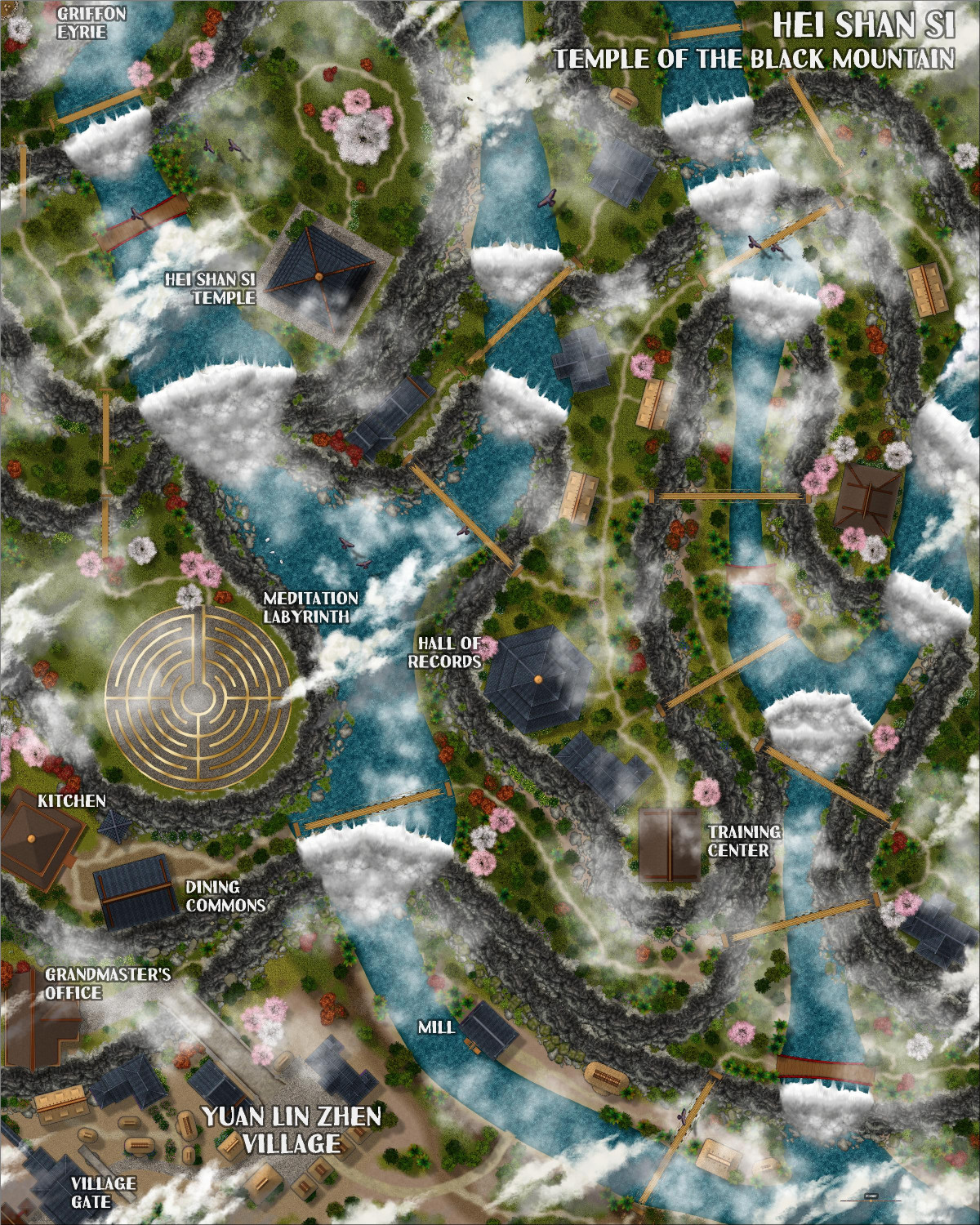
The Sacred Path of Hei Shan Si
In the heart of the Black Mountains and surrounded by the Ancient Forest, amidst peaks that touch the sky, stands the Hei Shan Si Monastery (Temple of the Black Mountain), a sanctuary of spiritual peace in contrast to the chaos of the surrounding region. Founded by an anonymous sage, the temple is said to have been built with the help of divine forces, its black walls harmonizing with the eternal shadows of the mountains.
The Challenging Path
The road to Hei Shan Si is a test in itself. It begins in the fertile valleys, and ends at the final stop in the village of Yuan Lin Zhen, passing through the living heart of the forest, steep cliffs and narrow trails that wind dangerously through the mountains. Incessant rain, dense fog and biting winds are constant companions of travelers. Worn rope bridges span unfathomable chasms, and legends tell of guardian spirits who punish those who disrespect them.
Beauty in the Wild
The temple sits on a plateau surrounded by stunning, untamed nature. Crystal-clear waterfalls feed rivers below, and flower gardens spring up naturally among the rocks. Rare birds soar overhead, their bright colors contrasting with the granite gray of the mountains. At dawn, the monastery seems to float amidst golden clouds, a sight that inspires reverence and humility.
Life at the Monastery
The monks and nuns who inhabit Hei Shan Si are few but dedicated. They live austere lives, cultivating the land and eating simple meals. They spend their days studying ancient spiritual texts, meditating on the edge of cliffs, and practicing rituals that are believed to purify the spirit and bring them closer to enlightenment.
Spiritual Ascension
Hei Shan Si is known for its unique teachings that combine philosophy, meditation, and the pursuit of balance with nature. The monks believe that the body and mind must be challenged in order to achieve enlightenment. In addition to their spiritual practices, they undertake rigorous physical exercises, such as climbing cliffs or meditating beneath icy waterfalls.
This place is not only a spiritual refuge, but a symbol of resilience and harmony in a land of turmoil. For the few who can overcome the hardships of the path and the shadows of their own hearts, the temple offers the promise of unparalleled peace and a glimpse of what it means to truly transcend the material world.

-
Live Mapping: Mike Schley Regional 2
Another great session -- thank you, Ralf. Always learn something new.
I know that Mike Schley is working on dungeon symbols at the moment (which I am thrilled about). I had two thoughts about new overland symbols in the future. One would be to expand on the cliff symbols to have more forward facing ones that don't curve at the ends so much, and maybe "back sides" of cliffs. The other would be transparent hills that take on the color/texture of the terrain they're on top of.
Thank you again!
-
WIP: Bleakmoor Harrow - Continent of Estonisch
It really is beautiful, and I think you've done a masterful job of combining symbols from different styles in ways that compliment each other rather than clashing.
-
[WIP] Wizard's Tower - Interior
No apologies necessary! I would be honored, and I would love to hear how it goes. I plan to find a home in the Atlas eventually, but I will post the FCWs here in the meantime with my blessing to use. Here are the FCWs for the outside, and for the third floor. I will post the other floors when they're ready.


